Method and system for collecting spatial data

A technology of spatial data and collection methods, which is applied in the directions of measuring instruments, instruments, surveying and mapping, and navigation, etc., and can solve problems such as inability to collect spatial geographic information data, lack of building facade data information, and spatial data limitations.

Active Publication Date: 2020-02-07
GUANGZHOU YIDONG NETWORK TECH
View PDF3 Cites 0 Cited by
  • Summary
  • Abstract
  • Description
  • Claims
  • Application Information

AI Technical Summary

Problems solved by technology

[0004] However, due to the limitations of hardware and external conditions, in the process of collecting spatial geographic information data by the vehicle-mounted mobile measurement system, it is easy to be blocked by trees, vehicles, pedestrians and other ground objects on the street, so that the blocked space cannot be collected. Geographical information data, resulting in the lack of data information on the building facades on both sides, making the collected spatial data limited

Method used


Image

  • Method and system for collecting spatial data
  • Method and system for collecting spatial data
  • Method and system for collecting spatial data

Examples


Embodiment Construction

[0054] Exemplary embodiments of the present disclosure will be described in more detail below with reference to the accompanying drawings. Although exemplary embodiments of the present disclosure are shown in the drawings, it should be understood that the present disclosure may be embodied in various forms and should not be limited by the embodiments set forth herein. Rather, these embodiments are provided for more thorough understanding of the present disclosure and to fully convey the scope of the present disclosure to those skilled in the art.

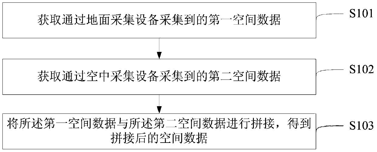
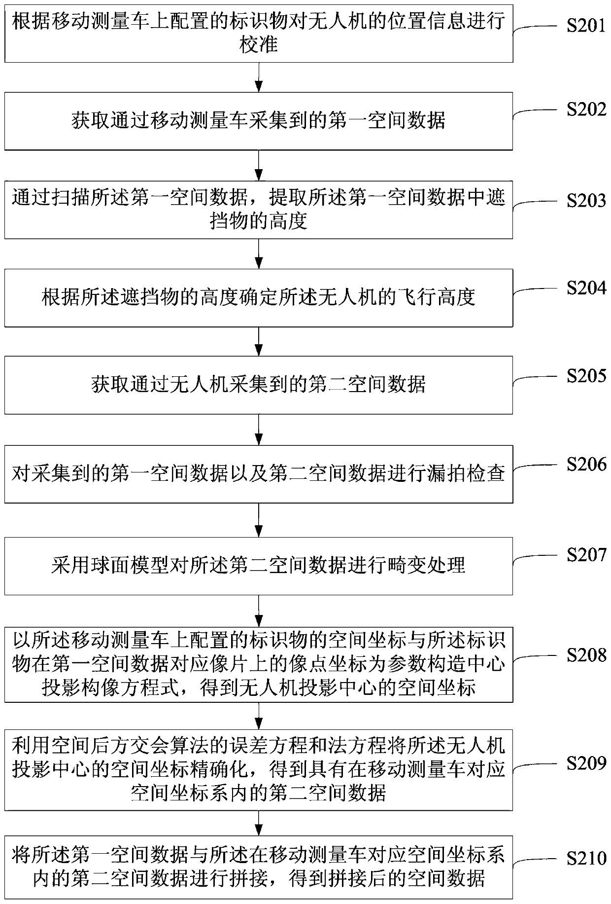
[0055] An embodiment of the present invention provides a method for collecting spatial data, such as figure 1 As shown, the method includes:

[0056] 101. Acquire first spatial data collected by ground collection equipment.

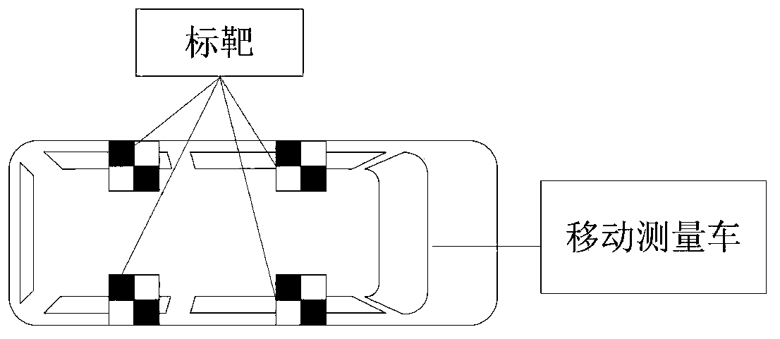
[0057] Wherein, the ground acquisition equipment can be a vehicle-mounted mobile measurement system, or other mobile acquisition equipment capable of collecting ground data, which is not limited in the embodi...


PUM


Abstract

The invention discloses a spatial data acquisition method and a spatial data acquisition system, and relates to the technical field of data acquisition. Sheltered spatio-temporal data of a missing part of a vehicle-mounted moving system can be acquired. The method comprises the following steps: acquiring first spatial data acquired through ground acquisition equipment; acquiring second spatial data acquired through air acquisition equipment; splicing the first spatial data and the second spatial data to obtain spliced spatial data. The spatial data acquisition method and the spatial data acquisition system are mainly used for acquisition of the spatial data.

Description

technical field [0001] The invention relates to the technical field of data collection, in particular to a spatial data collection method and system. Background technique [0002] In recent years, with the rapid development of the geographic information industry, roads and other infrastructures are changing with each passing day, and people's demand for spatial data is also increasing. In order to ensure that traffic management measures on the road are legal and effective, it is necessary to collect spatio-temporal data on both sides of the road or street , to grasp the urban traffic status by analyzing spatio-temporal data. [0003] The vehicle-mounted mobile measurement system is a multiple fusion system that integrates global satellite positioning module, inertial navigation module, 3D laser scanning module, panoramic image acquisition module and distance measurement module. The system can realize rapid and comprehensive spatial geographic information data acquisition. T...

Claims


Application Information

Patent Timeline
Patent Type & Authority Patents(China)
IPC IPC(8): G01C15/00
CPCG01C15/00
Inventor 黄鹤李若鹏衣鹏军罗德安邱冬炜仇凯悦潘兴楠白少博
Owner GUANGZHOU YIDONG NETWORK TECH
Why Eureka
Try Eureka