Remote sensing model method for regional vegetation transpiration and soil evaporation inversion based on thermal infrared remote sensing

A technology of thermal infrared remote sensing and vegetation transpiration, which is applied in the field of remote sensing models of regional vegetation transpiration and soil evaporation based on thermal infrared remote sensing. sexual effect

Inactive Publication Date: 2020-11-27
CHINA INST OF WATER RESOURCES & HYDROPOWER RES
View PDF10 Cites 16 Cited by
  • Summary
  • Abstract
  • Description
  • Claims
  • Application Information

AI Technical Summary

Problems solved by technology

[0005] Aiming at the difficulties and uncertainties existing in the inversion of regional vegetation transpiration and soil evaporation based on surface temperature, the

Method used


Image

  • Remote sensing model method for regional vegetation transpiration and soil evaporation inversion based on thermal infrared remote sensing
  • Remote sensing model method for regional vegetation transpiration and soil evaporation inversion based on thermal infrared remote sensing
  • Remote sensing model method for regional vegetation transpiration and soil evaporation inversion based on thermal infrared remote sensing

Examples


Embodiment 1

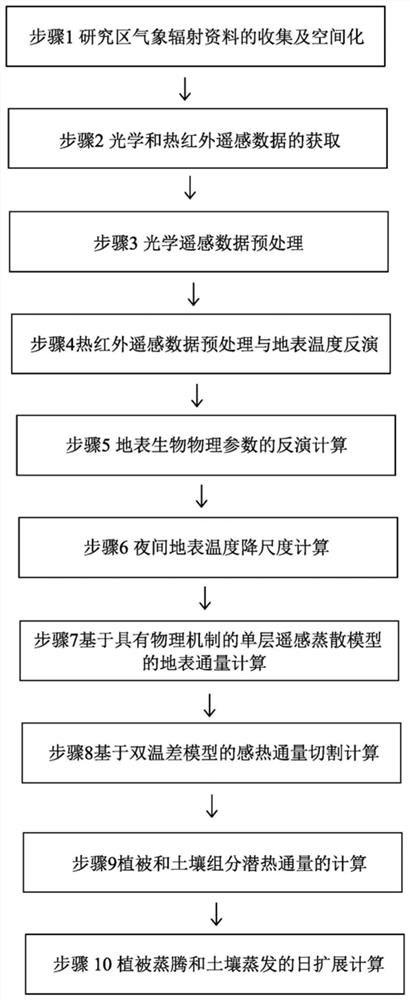
[0045] (1) Collection and spatialization of meteorological radiation data in the study area

[0046] According to research needs, collect and organize hourly and daily scale meteorological and radiation observation data in the study area. According to the needs of the research, download and obtain the digital elevation model data of the research area. The download website of the global digital elevation model data is: https: / / gdex.cr.usgs.gov / gdex / . Combining meteorological station locations and digital elevation model data enables spatial interpolation of meteorological and radiometric data.

[0047] (2) Acquisition of optical and thermal infrared remote sensing data

[0048] Collect medium-resolution satellite remote sensing data and low-resolution satellite remote-sensing data; the medium-resolution satellite remote-sensing data includes any one of Landsat 8 and ASTER satellite remote-sensing data; the low-resolution satellite remote-sensing data includes Terra / Aqua MODIS ...


PUM


Abstract

The invention discloses a remote sensing model method for regional vegetation transpiration and soil evaporation inversion based on thermal infrared remote sensing. The remote sensing model method comprises the steps of 1, collecting and spatializing meteorological radiation data of a research area; 2, acquiring optical and thermal infrared remote sensing data; 3, preprocessing the optical remotesensing data; 4, conducting thermal infrared remote sensing data preprocessing and surface temperature inversion; 5, carrying out inversion calculation of surface biophysical parameters; 6, performingnight surface temperature downscaling calculation; 7, calculating the surface flux based on a single-layer remote sensing evapotranspiration model with a physical mechanism; 8, carrying out sensitiveheat flux cutting calculation based on a double-temperature-difference model; 9, calculating latent heat flux of vegetation and soil components; and 10, performing daily expansion calculation of vegetation transpiration and soil evaporation. According to the method, the problems of high difficulty and uncertainty of regional vegetation transpiration and soil evaporation inversion based on the surface temperature at present are solved.

Description

technical field [0001] The invention belongs to the fields of water conservancy engineering, agricultural technology and ecological environment, and specifically relates to a remote sensing model method based on thermal infrared remote sensing for regional vegetation transpiration and soil evaporation inversion, and in particular proposes an evapotranspiration combining a single-layer model and a double-temperature difference model The cutting method can serve the application fields of crop water consumption estimation in agricultural irrigation areas, planning and management of regional water resources, evaluation of crop water use efficiency, and regional drought monitoring. Background technique [0002] Evapotranspiration, including soil evaporation and vegetation transpiration, is an important process of water and energy exchange in the atmosphere, hydrosphere and biosphere, and is closely related to the cycle of water, energy and carbon on the earth. As a key component ...

Claims


Application Information

Patent Timeline
IPC IPC(8): G01N21/17G01J5/00G06F30/20
CPCG01J5/007G01N21/171G01N2021/1793G06F30/20G06F2119/08G06F2119/14
Inventor 杨永民龙爱华杨昆黄诗峰李蓉朱鹤辛景峰马建威孙亚勇曲伟
Owner CHINA INST OF WATER RESOURCES & HYDROPOWER RES
Why Eureka
Try Eureka