Tourism geography data acquisition and management system

A geographic data and management system technology, applied in the field of geographic data collection, can solve problems such as low fidelity, interruption of data transmission, and high maintenance costs, and achieve the effects of ensuring real-time transmission, reducing workload, and facilitating query

Inactive Publication Date: 2017-10-10
PINGDINGSHAN UNIVERSITY
View PDF3 Cites 10 Cited by
  • Summary
  • Abstract
  • Description
  • Claims
  • Application Information

AI Technical Summary

Problems solved by technology

[0002] Most of the existing geographic data information collection systems use cameras and geographic information collection devices to collect geographic data, and then perform manual fusion processing in the later stage, which requires a lot of manpower, and data processing errors may occur in manual sorting. At the same time, the following defects generally exist:
[0003] (1) Before collecting geographic information, it is necessary to lay communication lines to meet the real-time transmission of the collected data. Once the signal is not good, it is easy to cause data transmission interruption, which is very inconvenient to use, and the maintenance cost is also high;
[0004] (2) The data collected by the camera is the data of a single surface, so that the obtained video data cannot be used for panoramic display of the geographical environment;
[0005] (3) The display of the collected data is mostly displayed in a flat three-dimensional module, with low fidelity;

Method used


Image

  • Tourism geography data acquisition and management system

Examples


Embodiment Construction

[0028] In order to make the objects and advantages of the present invention clearer, the present invention will be further described in detail below in conjunction with the examples. It should be understood that the specific embodiments described here are only used to explain the present invention, not to limit the present invention.

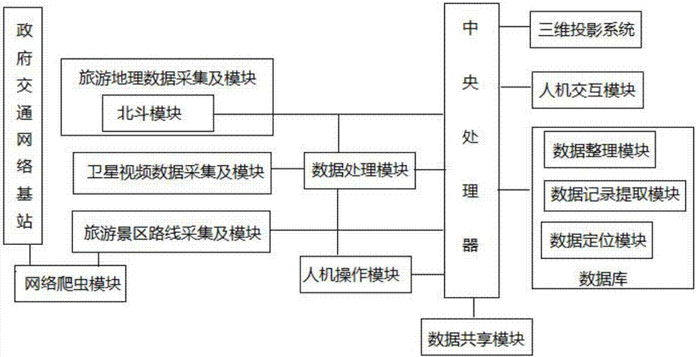
[0029] Such as figure 1 As shown, the embodiment of the present invention provides a tourism geographical data collection and management system, including

[0030] Tourism geographic information acquisition module, built-in Beidou module, used to obtain geographic space information data and weather parameter data in real time, and send the collected data to the data processing module through the Beidou module; the tourism geographic information acquisition module includes a total station , level gauge, GPS data acquisition vehicle and sensor acquisition module. The sensor acquisition module includes a displacement sensor, a slope sensor, a rai...


PUM


Abstract

The invention discloses a tourism geography data acquisition and management system which comprises a tourism geography information acquisition module, a satellite video acquisition module, a tourism region route acquisition module, a data processing module, a central processing unit, a three-dimensional projection system, a database and a man-machine interaction module. Data transmission can be realized by adopting a short message communication manner through a Beidou module, so that the cost is greatly lowered, and the real-time transmission of data can also be guaranteed; through the self data integration function, the workload of workers can be greatly lightened, and through applying the holographic projection technology, the three-dimensional display of geography information can be realized, so that the workers can observe and feel the geographic situations of tourism regions personally on the scene; and the database has data cleansing and positioning functions, so that the automatic classification and storage of data can be realized, and the workload of the workers can be lightened.

Description

technical field [0001] The invention relates to the field of geographic data collection, in particular to a tourism geographic data collection and management system. Background technique [0002] Most of the existing geographic data information collection systems use cameras and geographic information collection devices to collect geographic data, and then perform manual fusion processing in the later stage, which requires a lot of manpower, and data processing errors may occur in manual sorting. At the same time, the following defects generally exist: [0003] (1) Before collecting geographic information, it is necessary to lay communication lines to meet the real-time transmission of the collected data. Once the signal is not good, it is easy to cause data transmission interruption, which is very inconvenient to use, and the maintenance cost is also high; [0004] (2) The data collected by the camera is the data of a single surface, so that the obtained video data cannot ...

Claims


Application Information

Patent Timeline
Patent Type & Authority Applications(China)
IPC IPC(8): G06Q50/14G06F17/30H04W4/02G01S19/03G01D21/02
CPCG06Q50/14G01D21/02G01S19/03G06F16/29G06F16/951H04W4/02
Inventor 蔡文芳
Owner PINGDINGSHAN UNIVERSITY
Why Eureka
Try Eureka