The Changjiang River drainage basin information extracting and spatial coding method

A water body information and technology of the Yangtze River Basin, applied in the direction of instruments, analysis materials, computer components, etc., can solve problems such as inability to accurately reflect the overall environmental conditions of water bodies, to ensure scientificity and practicability, and realize real-time monitoring and data management Effect

Active Publication Date: 2017-12-19
NANJING FORESTRY UNIV +1
View PDF4 Cites 12 Cited by
  • Summary
  • Abstract
  • Description
  • Claims
  • Application Information

AI Technical Summary

Problems solved by technology

In the process of extracting water body information, due to the influence of factors such as complex surface environment, meteorological environment, geographical environment, water body itself and water quality problems caused by human activities, the accuracy of w

Method used


Image

  • The Changjiang River drainage basin information extracting and spatial coding method
  • The Changjiang River drainage basin information extracting and spatial coding method
  • The Changjiang River drainage basin information extracting and spatial coding method

Examples


Embodiment Construction

[0018] Below in conjunction with accompanying drawing and specific embodiment, further illustrate the present invention, should be understood that these embodiments are only for illustrating the present invention and are not intended to limit the scope of the present invention, after having read the present invention, those skilled in the art will understand various aspects of the present invention Modifications in equivalent forms all fall within the scope defined by the appended claims of this application.

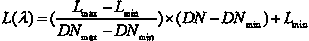
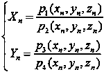
[0019] Such as figure 1 As shown, a method for water body information extraction and spatial encoding of the Yangtze River Basin includes the following steps:

[0020] (1) Atmospheric correction of high-resolution remote sensing images based on the atmospheric radiative transfer model 101;

[0021] (2) Geometric correction of high-resolution remote sensing images based on rational function models 102;

[0022] (3) High-resolution remote sensing image data mosaic proces...


PUM


Abstract

The invention provides the Changjiang River drainage basin information extracting and spatial coding method which comprises the following steps of (1), performing high resolution remote sensing image atmosphere correction based on an atmosphere radiation transmission model; (2), performing high resolution remote sensing image geographical correction based on a rational function model; (3), performing high resolution remote sensing image data embedding processing based on a Snake model; (4), performing high resolution remote sensing image data fusion processing based on wavelet transformation; (5), performing extraction based on object-oriented water body time-space information; and (6), performing water body information spatial coding based on a hierarchical classification method. The Changjiang River drainage basin information extracting and spatial coding method has advantages of 1), effectively realizing real-time monitoring and management for water environment and resource of the Changjiang River drainage basin; 2), supplying a scientific basis for the Changjiang River economic band development strategy, area ecology environment protection and planning; and 3), realizing suitability for spatial extraction and management of water body information in other drainage basins.

Description

technical field [0001] The invention relates to a method for extracting water body information in the Yangtze River Basin and its spatial encoding method, and belongs to the technical field of environmental monitoring and protection. Background technique [0002] As the longest river in China, the longest river in Asia and the third longest river in the world, the Yangtze River runs through nine provinces (Qinghai, Tibet, Sichuan, Yunnan, Hubei, Hunan, Jiangxi, Anhui and Jiangsu) and two cities from west to east. Chongqing and Shanghai) and the three major economic plates, connecting the three major urban agglomerations of the Yangtze River Delta urban agglomeration, the middle reaches of the Yangtze River urban agglomeration and the Chengdu-Chongqing urban agglomeration, are of great significance to the spatial and temporal layout of China's social and economic development and ecological environment construction. Under the influence of global climate change and human activi...

Claims


Application Information

Patent Timeline
IPC IPC(8): G06K9/00G06K9/62G01N21/17
CPCG01N21/17G01N2021/1793G06V20/13G06F18/251
Inventor 杨强何立恒周权平张洁郑加柱陈红华陈动蔡逸涛刘林何龙江
Owner NANJING FORESTRY UNIV
Why Eureka
Try Eureka