Orchard operation robot unmanned driving method based on point cloud map

An operating robot and unmanned driving technology, applied in the field of navigation, can solve the problems of difficulty in obtaining accurate inter-line positioning and navigation effects, satellite signal occlusion, and high cost, so as to improve the success rate of U-turns, improve navigation efficiency, and control costs Effect

Pending Publication Date: 2021-06-15
CHENGDU UNIV OF INFORMATION TECH
View PDF3 Cites 7 Cited by
  • Summary
  • Abstract
  • Description
  • Claims
  • Application Information

AI Technical Summary

Problems solved by technology

During the working process, the robot will generally be located below the canopy. If GPS is used for positioning alone, there will be problems such as satellite signals being blocked by the canopy, multi-path effects, and radio frequency interference, which will eventually lead to large position errors of the robot, or even failure to locate.
The distance between orchard rows is mostly only about 3m, and it is difficult to obtain accurate inter-row positioning and navigation effects by using GPS; electromagnetic navigation positioning can have better positioning and navigation effects, but the cost is relatively high

Method used


Image

  • Orchard operation robot unmanned driving method based on point cloud map
  • Orchard operation robot unmanned driving method based on point cloud map
  • Orchard operation robot unmanned driving method based on point cloud map

Examples


Embodiment Construction

[0034] The present invention will be further described in detail below in conjunction with the accompanying drawings, so that those skilled in the art can implement it with reference to the description.

[0035] It should be understood that terms such as "having", "comprising" and "including" as used herein do not entail the presence or addition of one or more other elements or combinations thereof.

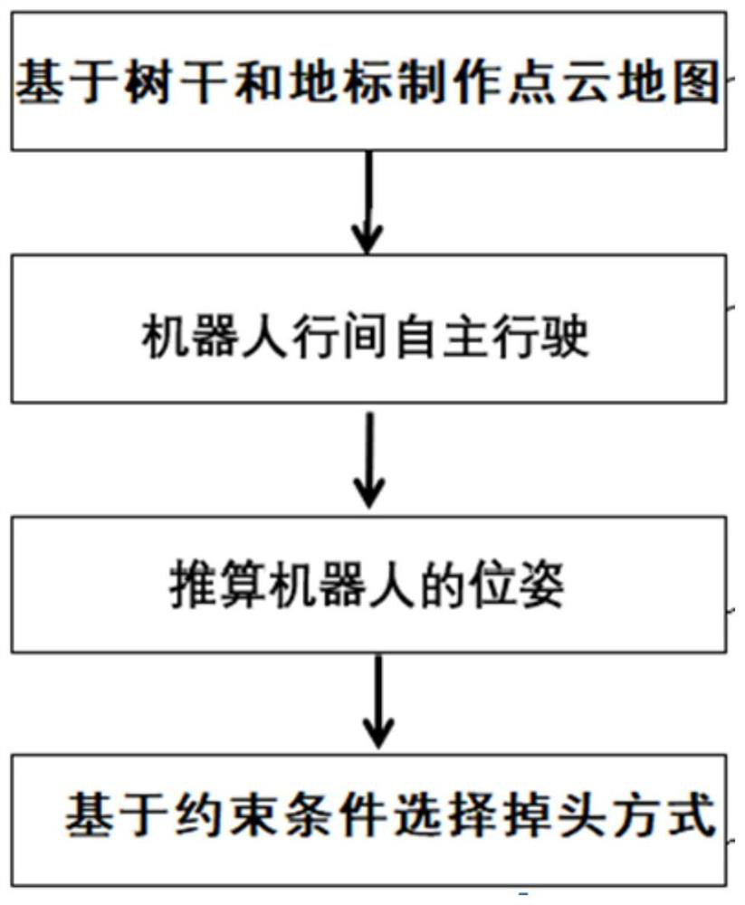
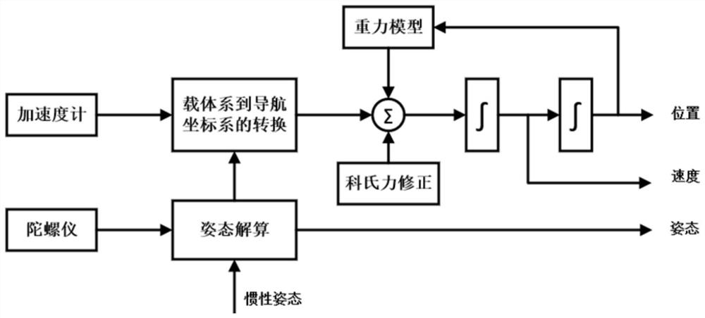
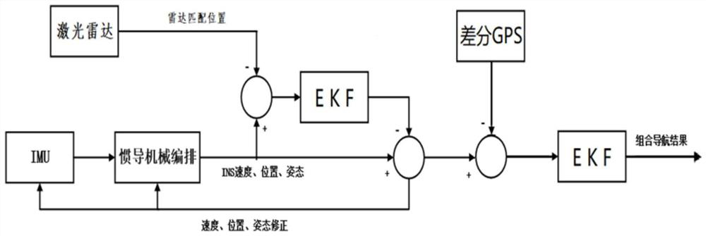
[0036] The invention provides a method based on point cloud maps and inertial navigation assistance for the problem that the robot cannot accurately locate GPS and turn around accurately when the robot is driving in a densely planted orchard. This invention guarantees that the robot can complete the work autonomously in the semi-structured environment of the orchard (with clear distribution of rows and columns of fruit trees). Specifically, the orchard unmanned driving method based on the point cloud map of the present invention is as follows:

[0037] Step 1: Make a point cloud...


PUM


Abstract

The invention discloses an orchard operation robot unmanned driving method based on a point cloud map. The method comprises the steps of: 1, positioning tree crowns and road signs at the periphery of an orchard region through a differential GPS, and marking the absolute positions of trees and the road signs; 2, scanning and recording key feature trunks by using a laser radar and recording corresponding feature signals to obtain a corresponding point cloud map; 3, making the operation robot mark a real-time position on the point cloud map; and 4, continuously scanning tree trunk information through the laser radar to correspond to GPS signal points on the point cloud map so as to calculate the advancing pose of the robot and correct the advancing direction of the robot. With the orchard operation robot unmanned driving method based on the point cloud map provided by the invention adopted, the robot can achieve precise travel, turning and searching for the next row under the assistance of the point cloud map with position labels added in an orchard and inertial navigation under the condition that a GPS does not exist between rows, and the requirements of the robot for continuous work in the orchard can be met.

Description

technical field [0001] The invention relates to the technical field of navigation. More specifically, the present invention relates to an unmanned driving method for an orchard operating robot based on a point cloud map. Background technique [0002] Multifunctional agricultural robots are widely used, making agricultural robots more and more replace manual work in the vast fields. The tasks of orchard production in agriculture are various and require a lot of manpower and material resources. At the same time, inaccurate orchard management methods will generate a lot of ineffective inputs and ecological pollution, which will increase fruit prices. In response to these situations, it is imperative to develop intelligent and precise robots suitable for orchard operations. Robots should replace human labor and work autonomously in orchards. The construction of environmental maps is the primary task for robots to complete positioning and autonomous navigation. Using the constr...

Claims


Application Information

Patent Timeline
Patent Type & Authority Applications(China)
IPC IPC(8): G05D1/02
CPCG05D1/0257G05D2201/0217
Inventor 付克昌蔡明希蒋涛胡泽邹艳玲张林帅王月红罗辉胥祥崔亚男段翠萍
Owner CHENGDU UNIV OF INFORMATION TECH
Why Eureka
Try Eureka