Three-dimensional field staff positioning navigation system

A technology of three-dimensional positioning and navigation system, which is applied in directions such as navigation through speed/acceleration measurement, and can solve problems such as increased inertial navigation positioning error, sensitivity to light and light paths, and ineffective algorithms, and achieves the effect of convenient integration and small size

Inactive Publication Date: 2014-03-05
JINLING INST OF TECH
View PDF0 Cites 15 Cited by
  • Summary
  • Abstract
  • Description
  • Claims
  • Application Information

AI Technical Summary

Problems solved by technology

The disadvantages of this method are: slow speed, small positioning range, sensitivity to light and light path, image processing algorithm is not very effective, etc.
However, the positioning error of inertial navigation will gradually increase with time, and error correction must be carried out continuously to ensure the required accuracy

Method used


Image

  • Three-dimensional field staff positioning navigation system

Examples


Embodiment 1

[0018] A three-dimensional positioning and navigation system for on-site personnel, including the following parts: personnel location identification tags are used to identify firefighters to locate their positions and send relevant information to the server, the location data transmission module is used to send and receive the above information, and the personnel positioning three-dimensional display The platform is used to display the location and walking track of people based on the received information. The personnel location identification tag includes an inertial navigation module and a wireless data transmission module. The inertial navigation module is used for real-time monitoring of the movement distance of the current identification tag, the height of the direction angle, and various attitude parameters of the inclination angle. The position-related parameters are passed through wireless data transmission. The transmission module is sent to the server. The location d...

Embodiment 2

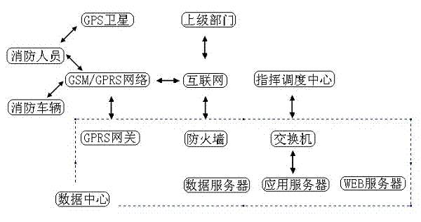
[0020] like figure 1 As shown, the firefighters locate the location information through GPS satellites and connect to the GPRS gateway of the data center through the GSM / GPRS network. The fire trucks also connect to the GPRS gateway of the data center through the GPRS network. It is connected with the superior fire department through a firewall and the Internet, and the switch is connected with the computer of the command and dispatch center, and the switch includes a data server, an application server and a WEB server.

[0021] Operation process:

[0022] 1. Geo-referenced 3D models can be quickly formed through Google Earth, CAD (Computer Aided Design), or other digital drawing software programs;

[0023] 2. After finding the place where the accident happened through Google Earth, you can quickly form a visual three-dimensional wireframe by clicking the mouse;

[0024] 3. The formation of 3D wireframe buildings is very simple using Google Earth, all that is required is for...


PUM


Abstract

The invention relates to a three-dimensional field staff positioning navigation system which is a fire-alarm field fireman positioning system. The three-dimensional field staff positioning navigation system comprises the following parts: a staff positioning identification tag, a position data transmission module and a staff positioning three-dimensional display platform, wherein the staff positioning identification tag is used for identifying the fireman identity to position the fireman and transmitting related information to a server; the position data transmission module is used for transmitting and receiving the information; the staff positioning three-dimensional display platform is used for displaying the staff position and walking track according to the received information. The three-dimensional field staff positioning navigation system is a low-cost high-performance small blind area estimated navigation device provided for the walking staff based on an inertial technology. The walking distance and direction information of the staff are output in real time in a wireless mode, the staff position can be continuously determined under the condition that a global position system (GPS) is absent, the position error is irrelevant to time, and the system mainly depends on the passed distance. The equipment is small in size and can be conveniently integrated into conventional product equipment in a wireless data transmission mode.

Description

technical field [0001] The invention relates to a three-dimensional positioning and navigation system for on-site personnel, which is a fire-fighting on-site positioning system for firefighters. Background technique [0002] There are many ways to realize three-dimensional positioning. The first common method is based on optics, that is, to obtain three-dimensional positioning information through dual or single cameras. The disadvantages of this method are: slow speed, small positioning range, sensitivity to light and light path, and ineffective image processing algorithm. The second method is based on magnetism, that is, the measured object emits a magnetic field, and a magnetic sensor can determine the position of the measured object according to the strength of the magnetic field and the declination angle of the magnetic field. The advantage of this square string is not that it depends on the observation of a straight line (that is, there is no object blocking between th...

Claims


Application Information

Patent Timeline
Patent Type & Authority Applications(China)
IPC IPC(8): G01C21/16
CPCG01C21/16
Inventor 张波
Owner JINLING INST OF TECH
Why Eureka
Try Eureka