Automatic Generation Method of 3D Virtual City

A three-dimensional virtual and automatic generation technology, applied in the field of virtual cities, can solve the problem that the land use model cannot fully and accurately reflect the distribution of roads and buildings in the city

Inactive Publication Date: 2017-08-25
INST OF REMOTE SENSING & DIGITAL EARTH CHINESE ACADEMY OF SCI
View PDF3 Cites 0 Cited by
  • Summary
  • Abstract
  • Description
  • Claims
  • Application Information

AI Technical Summary

Problems solved by technology

[0005] The invention provides a method for automatically generating a three-dimensional virtual city, which is used to solve the technical problem that the land use model in the prior art cannot fully and accurately reflect the distribution of roads and buildings in the city

Method used


Image

  • Automatic Generation Method of 3D Virtual City
  • Automatic Generation Method of 3D Virtual City
  • Automatic Generation Method of 3D Virtual City

Examples


Embodiment 1

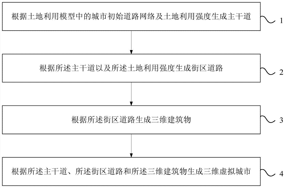
[0018] figure 1 It is a flow chart of the method for automatically generating a 3D virtual city provided by Embodiment 1 of the present invention. Such as figure 1 As shown, the automatic generation method of the three-dimensional virtual city in this embodiment may include:

[0019] Step 1. Generate arterial roads according to the initial urban road network and land use intensity in the land use model.

[0020] Specifically, when the planner needs to simulate a brand new city, the initial urban road network can be empty, that is, multiple main roads are generated directly according to the land use intensity; when the planner needs to simulate urban expansion on the basis of the existing urban area , the initial road network of the city can include the main roads of the existing urban areas, and on the basis of the initial road network formed by the main roads of the existing urban areas, new main roads are generated according to the intensity of land use.

[0021] Urban ro...

Embodiment 2

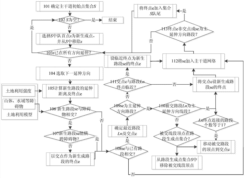
[0032] figure 2 It is a flow chart of generating arterial roads in the method for automatically generating a 3D virtual city provided in Embodiment 2 of the present invention. This embodiment is based on the method for automatically generating a three-dimensional virtual city provided in the first embodiment, and provides a specific implementation of step 1. In this embodiment, main roads are generated according to the initial urban road network and land use intensity in the land use model, which may specifically include:

[0033] Determine the initial point of the main road for extending the main road according to the initial road network of the city, form a set of initial points of the main road, determine the extension direction for each initial point of the main road, and the extension direction includes a main extension direction and at least one secondary The direction of extension, and perform the following steps in turn for each initial point of the main road in the ...

Embodiment 3

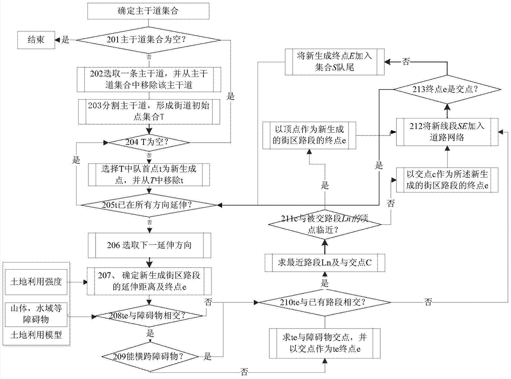
[0082] image 3 It is a flow chart of generating block roads in the method for automatically generating a 3D virtual city provided by Embodiment 3 of the present invention. This embodiment is based on the method for automatically generating a three-dimensional virtual city provided in the first embodiment, and provides a specific implementation of step 2. In this embodiment, generating block roads according to the main road and the land use intensity may specifically include:

[0083] Determine the initial street point for extending the block road according to the main road, form a street initial point set, determine the extension direction for each street initial point, and execute the following steps in sequence for each street initial point in the street initial point set The above steps:

[0084] A new block section is generated in each extension direction of the initial point of the street, and the land use intensity covered by the newly generated block section satisfie...


PUM


Abstract

The present invention provides a method for automatically generating a three-dimensional virtual city, including: generating main roads according to the initial urban road network and land use intensity in the land use model; generating block roads according to the main roads and the land use intensity; generating three-dimensional buildings based on the block roads; generating a three-dimensional virtual city according to the main roads, the block roads and the three-dimensional buildings. In the method for automatically generating a three-dimensional virtual city provided by the present invention, on the basis of the initial urban road network provided by the land use model, main roads are generated according to land use intensity, and further generated by using the main roads and the land use intensity Block roads and three-dimensional buildings, and then generate a three-dimensional virtual city corresponding to the land use model, which can comprehensively, accurately and intuitively reflect the distribution of roads and buildings in the city.

Description

technical field [0001] The invention relates to the technical field of virtual cities, in particular to an automatic generation method of a three-dimensional virtual city. Background technique [0002] A city is a complex system composed of many types of objects. Urban form can be manifested as different land use patterns and is the result of the interaction between human and natural systems in the city. Urban planners and policymakers hope to shape the desired urban form through the plans and policies they formulate. [0003] In the prior art, city planners can design different urban land use models according to the specific conditions of the city. The urban land use model can include the land types of each area in the city, such as industrial land, commercial land, and civil land, etc., and can also include the land use intensity and volume ratio of each area in the city. [0004] However, the existing land use models are usually based on two-dimensional maps, and can o...

Claims


Application Information

Patent Timeline
Patent Type & Authority Patents(China)
IPC IPC(8): G06T19/00
Inventor 宇林军刘亚岚彭玲池天河
Owner INST OF REMOTE SENSING & DIGITAL EARTH CHINESE ACADEMY OF SCI
Why Eureka
Try Eureka