TRMM (Tropical Rainfall Measuring Mission) satellite rainfall data downscaling method based on M5-Local

A rainfall data and downscaling technology, which is applied in the direction of electrical digital data processing, special data processing applications, measuring devices, etc., can solve problems such as inability to improve accuracy, and achieve the effect of improving spatial resolution

Active Publication Date: 2015-12-16
ZHEJIANG UNIV
View PDF4 Cites 33 Cited by
  • Summary
  • Abstract
  • Description
  • Claims
  • Application Information

AI Technical Summary

Problems solved by technology

However, current researchers believe that the use of multi-factor downscaling algorithms cannot i

Method used


Image

  • TRMM (Tropical Rainfall Measuring Mission) satellite rainfall data downscaling method based on M5-Local
  • TRMM (Tropical Rainfall Measuring Mission) satellite rainfall data downscaling method based on M5-Local
  • TRMM (Tropical Rainfall Measuring Mission) satellite rainfall data downscaling method based on M5-Local

Examples


Embodiment 1

[0025] In this embodiment, geographically weighted regression is used for downscaling prediction, and the specific steps are as follows:

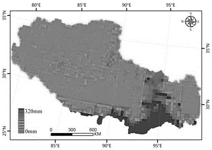
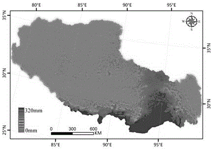
[0026] The Tibet region was selected as the research area, and the monthly rainfall in the wet season (May-October) of 2003-2009 was predicted and studied, and finally the monthly rainfall distribution map with a spatial resolution of 1km was obtained.

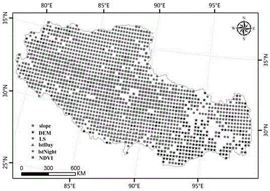
[0027] Step 1) Data acquisition: Obtain TRMM meteorological satellite remote sensing image data, MODIS satellite remote sensing image data and ASTERGDEM satellite remote sensing image data in the Tibet region, and collect daily rainfall observations at ground observation stations in the Tibet region; the MODIS satellite remote sensing image data Including MOD11A2 data product and MOD13A2 data product. Wherein: the spatial resolution of the TRMM meteorological satellite remote sensing image data is 0.25°×0.25°, and the time resolution is 3 hours; the spatial resolution of the ASTERGDEM satel...

Embodiment 2

[0038] In this embodiment, the M5-LocalR method is used for regression modeling, and the specific steps are as follows: In this embodiment, geographic weighted regression is used for downscaling prediction, and the specific steps are as follows:

[0039] The Tibet region was selected as the research area, and the monthly rainfall in the wet season (May-October) of 2003-2009 was predicted and studied, and finally the monthly rainfall distribution map with a spatial resolution of 1km was obtained.

[0040] Step 1) Data acquisition: Obtain TRMM meteorological satellite remote sensing image data, MODIS satellite remote sensing image data, and ASTERGDEM satellite remote sensing image data in the Tibet region, and collect daily rainfall observations at ground observation stations in the Tibet region; the MODIS satellite remote sensing image data The data includes MOD11A2 data product and MOD13A2 data product. Wherein: the spatial resolution of the TRMM meteorological satellite remot...


PUM


Abstract

The invention discloses a TRMM (Tropical Rainfall Measuring Mission) satellite rainfall product downscaling method based on M5-Local and a multi-environmental factor variable. An M5-Local regression thought is adopted, and a plurality of environment stress factors with high spatial resolutions are fully utilized to improve the spatial resolution of the product. Firstly, 1km environmental variable factors, such as eight pieces of data including a vegetation index, a digital elevation model, a daytime surface temperature, a night surface temperature, a terrain moisture index, a gradient, a slope aspect and a slope length gradient, are subjected to aggregate calculating to obtain 25km which serves as an independent variable, corresponding 25km-resolution TRMM data is used as a dependent variable, an M5-Local method is adopted for modeling, the intercept of a regression modeling equation of 1km spatial resolution and a slope parameter corresponding to each environment factor variable are predicted, and a 1kmTRMM rainfall value is calculated. A downscaling result based on an M5-Local model is obviously superior to a downscaling result of a conventional regression model.

Description

technical field [0001] The invention relates to a method for downscaling TRMM rainfall data, in particular to a method for downscaling TRMM satellite rainfall data based on M5-Local. technical background [0002] Rainfall plays an important role in the fields of hydrology, meteorology, ecology, and agricultural research, especially an important part of the conservation of matter-energy exchange. Surface observation station is a widely used means of rainfall measurement, and has the characteristics of high precision and mature technology. However, the rainfall monitored by surface observation stations only represents the precipitation conditions at a certain distance from the surface observation stations and surrounding areas, so it is difficult to describe the characteristics of large-scale rainfall distribution, especially in plateau areas where the network density of surface observation stations is sparse. The satellite remote sensing technology can provide rainfall data ...

Claims


Application Information

Patent Timeline
IPC IPC(8): G06F19/00G01W1/10
Inventor 史舟马自强刘用吕志强
Owner ZHEJIANG UNIV
Why Eureka
Try Eureka