Fusion method based on diversified geographic information points

A fusion method and technology of geographic information, applied in the field of geographic information processing, can solve the problems that cannot be obtained, stop words cannot be ignored, and cannot fully reflect the semantic similarity of text, so as to improve efficiency, change mechanical and low efficiency Effect

Active Publication Date: 2017-10-17
山东高速云南发展有限公司
View PDF5 Cites 10 Cited by
  • Summary
  • Abstract
  • Description
  • Claims
  • Application Information

AI Technical Summary

Problems solved by technology

But for short texts, because similar short texts do not necessarily have the same words, the flexibility of natural language allows people to express the same meaning through different wordings, so the existing similarity calculation methods are not effective. Good, e.g. poor performance in data handling of geolocation names
In addition, in the traditional text similarity calculation process, stop words are usually removed from the expression of the text, such as "的", "是", "中", etc., but in the process of processing short texts, because they contain some sentence structure information, so some stop words cannot be ignored, which makes the traditional text similarity calculation method can not get good results in the process of text similarity calculation for short text
[0005] For the calculation of text similarity, the commonly used method for calculating the similarity between texts is the cosine similarity method, which regards the text as a point in space and expresses it as a vector form, and uses the angle between the vectors to Quantitatively calculate the similarity between texts, this method does not consider the feature words with the same semantics between texts, and cannot fully reflect the semantic similarity between texts
Therefore, there are a lot of shortcomings and omissions in the existing similarity calculation methods

Method used


Image

  • Fusion method based on diversified geographic information points
  • Fusion method based on diversified geographic information points
  • Fusion method based on diversified geographic information points

Examples


Embodiment 1

[0046] Embodiment 1: a kind of fusion method based on diversified geographic information points, the specific steps are:

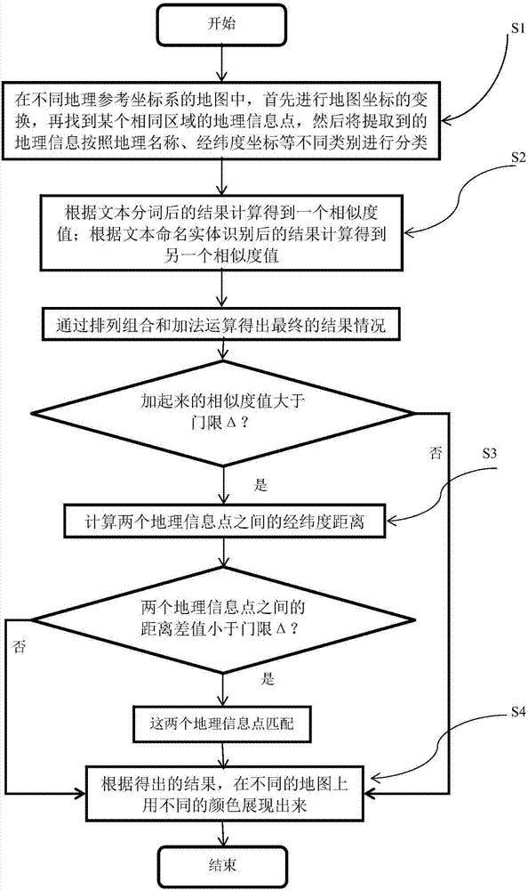
[0047] (A), information extraction and preprocessing: In maps of different geographic reference coordinate systems, firstly carry out the transformation of map coordinates, and then find a geographic information point in the same area, and then extract the geographic information according to geographic name, latitude and longitude Classify different categories such as coordinates;

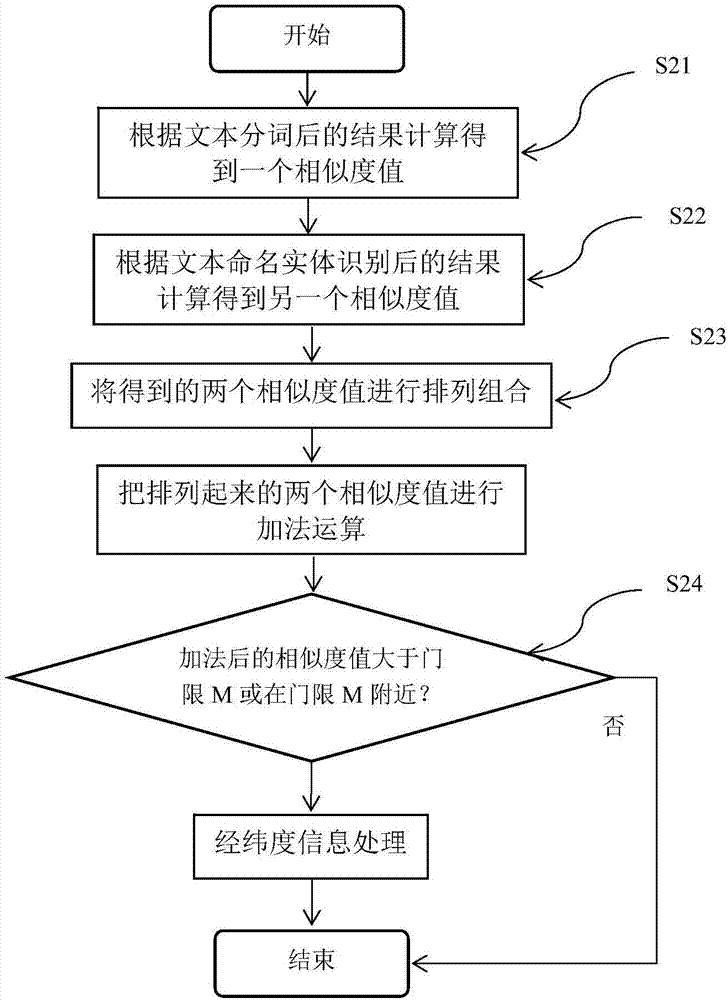
[0048](B) Geographic names in geographic information first define similarity: including four steps of similarity processing after word segmentation, similarity processing after named entity recognition, permutation and addition, based on the calculation of two similarity values Judging by the results, if they are not similar, the matching ends, and the geographical names of multiple geographic information points are not the same; if they are similar or uncertain, then match bet...

Embodiment 2

[0070] Embodiment 2: as figure 1 As shown, the fusion method based on multiple geographical information points of the present invention will be further described in detail below.

[0071] The specific steps of the fusion method based on the geographical information points of two kinds of maps are as follows:

[0072] Step S1, information extraction and preprocessing, is to first transform the map coordinates in maps of different geographic reference coordinate systems, and then find a geographic information point in the same area, and then extract the geographic information according to geographic name, latitude and longitude Classify different categories such as coordinates;

[0073] Step S2, the geographic name in the geographic information first defines the similarity, including four steps of similarity processing after word segmentation, similarity processing after named entity recognition, permutation and combination, and addition, based on the results obtained by calcul...


PUM


Abstract

The invention relates to a fusion method based on diversified geographic information points, and belongs to the technical field of geographic information processing. According to the method, the geographic information data matching is performed through finding a certain identical region in a map with different geographic reference coordinate systems; whether geographic information of different maps has the identical information points or not is found; and the method relates to the field of geography and information processing. The method comprises the following steps of defining the similarity degrees of geographic names in a plurality of geographic information points; obtaining a plurality of similarity degree values through calculation according to the result after the text segmentation and the text name entity recognition; then, whether the geographic names of a plurality of geographic information points are similar or not is judged according to the final result condition of permutation and combination and additive operation; if the geographic names are not similar, the matching is completed, and the geographic names of the plurality of geographic information points are different; and if the geographic names are similar or the condition is uncertain, the matching between latitude and longitude distances of the plurality of geographic information points is performed.

Description

technical field [0001] The invention relates to a fusion method based on multiple geographic information points, belonging to the technical field of geographic information processing. Background technique [0002] In recent years, with the large-scale development of the network, the number of various information resources has increased sharply, and the popularity of computers for various natural language processing applications such as geographical names and coordinate information. People need a fast and accurate method to calculate multiple geographic information. Information similarity between information points. In particular, the calculation of short text similarity plays a very important role, and its application can greatly improve the accuracy of identifying multiple geographic information points. In addition, the latitude and longitude information in the map is very convenient for the query of adjacent areas, and the fusion method of establishing geographic informat...

Claims


Application Information

Patent Timeline
Patent Type & Authority Applications(China)
IPC IPC(8): G06F17/30
CPCG06F16/29
Inventor 龙华吕丹杜庆治邵玉斌
Owner 山东高速云南发展有限公司
Why Eureka
Try Eureka