Ground three-dimensional laser point cloud and ground penetrating radar image fusion method

A technology of ground penetrating radar and three-dimensional laser, applied in the field of image processing, can solve the problems of uncertain fusion accuracy and lack of good data fusion implementation methods, so as to improve the accuracy, promote mutual interpretation, and overcome the defects of a single data source. Effect

Active Publication Date: 2018-01-05
HENAN INST OF ENG
View PDF5 Cites 24 Cited by
  • Summary
  • Abstract
  • Description
  • Claims
  • Application Information

AI Technical Summary

Problems solved by technology

[0005] Aiming at the technical problem that there is no better fusion method for ground laser point cloud and ground penetrating radar image data, and the fusion accuracy is uncertain, this invention proposes a method for ground three-dimensional laser point cloud and ground penetrating radar image fusion, which solves the two problems. The problem of registration

Method used


Image

  • Ground three-dimensional laser point cloud and ground penetrating radar image fusion method
  • Ground three-dimensional laser point cloud and ground penetrating radar image fusion method
  • Ground three-dimensional laser point cloud and ground penetrating radar image fusion method

Examples


Embodiment Construction

[0054] The following will clearly and completely describe the technical solutions in the embodiments of the present invention with reference to the accompanying drawings in the embodiments of the present invention. Obviously, the described embodiments are only some, not all, embodiments of the present invention. Based on the embodiments of the present invention, all other embodiments obtained by persons of ordinary skill in the art without making creative efforts belong to the protection scope of the present invention.

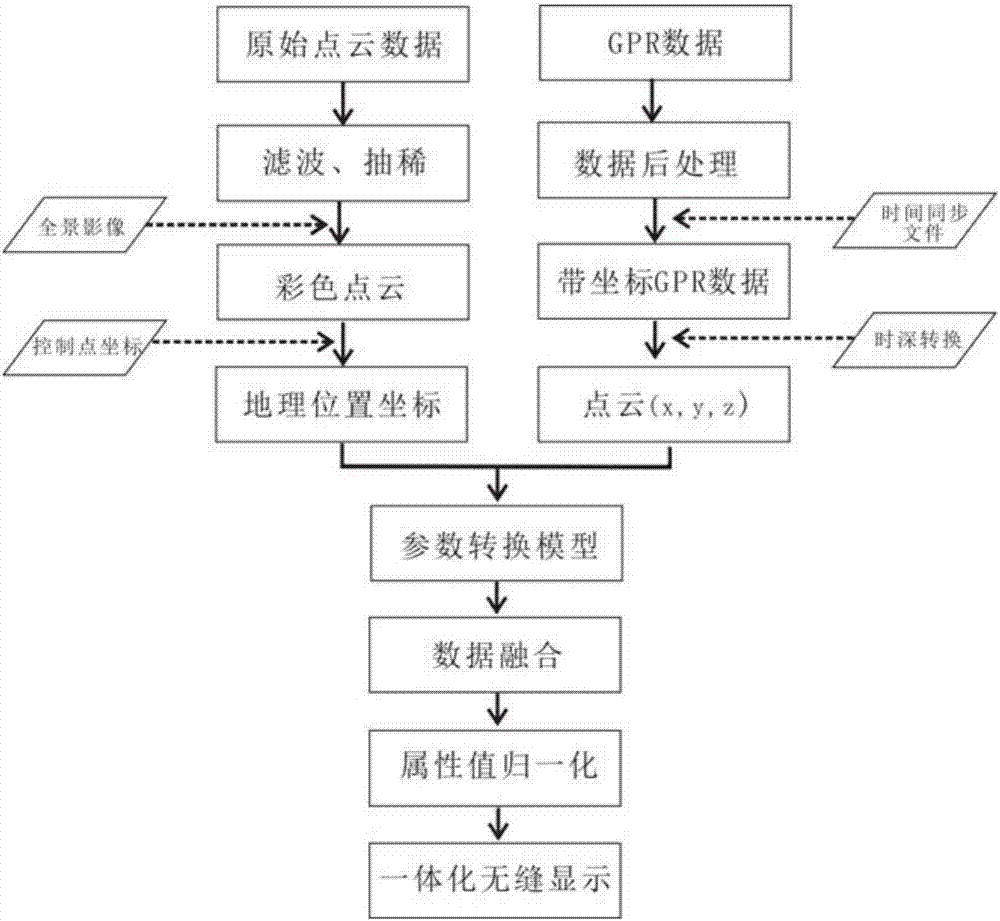
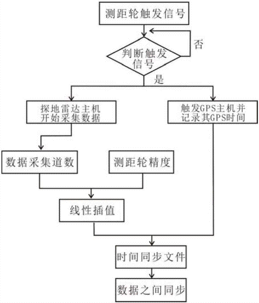
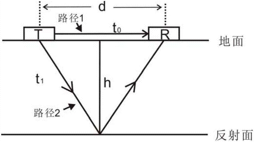
[0055] Such as figure 1 As shown, a method for fusion of ground 3D laser point cloud and ground-penetrating radar image is based on the synchronous acquisition of ground-penetrating radar and GPS data to improve the electromagnetic wave path propagation model, combined with geographic reference absolute positioning equation and coordinate conversion Unify the source heterogeneous data into the same coordinate system to realize its data fusion display. The proc...


PUM


Abstract

The invention discloses a ground three-dimensional laser point cloud and ground penetrating radar image fusion method. On the basis of ground penetrating radar image and GPS data synchronization acquisition, an improved electromagnetic wave path propagation model is used for realizing time-depth conversion of the ground penetrating radar image, with a coordinate system of the ground three-dimensional laser data as reference, a geo reference absolute positioning equation is combined to convert two-different source isomerism data to the same coordinate system, and data fusion is realized. According to data features of a ground three-dimensional laser scanner and the ground penetrating radar, a three-dimensional laser point cloud and ground penetrating radar image fusion method is provided. The experiment result and error analysis prove that the process is simple, the fusion precision is high, and the adaptability is wide. Differences between resolutions and data amounts of the two-different source isomerism data are overcome, advantages of each of the three-dimensional laser scanner and the ground penetrating radar are executed thoroughly, and effective fusion of two different typesof data is realized.

Description

technical field [0001] The invention relates to the field of image processing, in particular to a method for fusing ground three-dimensional laser point clouds and ground-penetrating radar images. Background technique [0002] As a non-destructive geophysical detection technology that uses high-frequency electromagnetic waves to determine the structure of shallow strata, ground-penetrating radar has been widely used in archaeological detection and geological engineering investigation due to its simple operation, wide detection range, deep detection depth and high resolution. , Highway disease detection, road cavity and groundwater pollution detection and many other fields, and achieved good application results. The terrestrial 3D laser scanner quickly obtains the external geometry or 3D scene of the measured object by means of non-contact measurement, and has been widely used in recent years. [0003] The ground-based 3D laser scanner can obtain the fine geometric form or 3...

Claims


Application Information

Patent Timeline
IPC IPC(8): G01V3/12G01S19/42G01S13/89G06K9/62G06T7/30
Inventor 张迪刘绍堂王果蒋瑞波肖海红
Owner HENAN INST OF ENG
Why Eureka
Try Eureka