The selection method of the fixed-wing unmanned aerial vehicle take-off and landing point selection system in mountainous areas

A fixed-wing, aircraft mountain technology, applied in the field of drone aerial survey, can solve the problems of no drone take-off and landing point selection method, increase the cost of drone aerial survey operations, and unfavorable safe landing of drones, and achieve effective safety. Take-off and landing, small error, ensure the effect of safe take-off and landing

Active Publication Date: 2019-07-30
NORTH CHINA UNIV OF WATER RESOURCES & ELECTRIC POWER
View PDF2 Cites 0 Cited by
  • Summary
  • Abstract
  • Description
  • Claims
  • Application Information

AI Technical Summary

Problems solved by technology

When performing surveying and mapping tasks, it is inevitable to encounter more complex terrain conditions, and it is impossible to find a large area of ​​open space, which is extremely unfavorable for the safe landing of drones
In the mountains, there are many cliffs and cliffs. The strong winds in the valleys also have a great impact on the safety of drones. It is extremely difficult to find an open place where drones can take off and land safely. Searching aimlessly will waste a lot of time. , increasing the operating cost of UAV aerial survey
In addition, the existing take-off and landing point selection method is only a part of the UAV aerial survey algorithm. There are still many areas that need to be improved in the selection of the take-off and landing area when the UAV takes off and lands. There is no more logical algorithm to support it. , even if a more rigorous field survey and map marking of the survey area are carried out, selection errors are prone to occur, which will cause accidents; moreover, there is no method for selecting take-off and landing points specifically for fixed-wing UAVs, which will undoubtedly cause Inaccurate aerial survey greatly increases the cost of UAV aerial survey

Method used


Image

  • The selection method of the fixed-wing unmanned aerial vehicle take-off and landing point selection system in mountainous areas
  • The selection method of the fixed-wing unmanned aerial vehicle take-off and landing point selection system in mountainous areas
  • The selection method of the fixed-wing unmanned aerial vehicle take-off and landing point selection system in mountainous areas

Examples


Embodiment 1

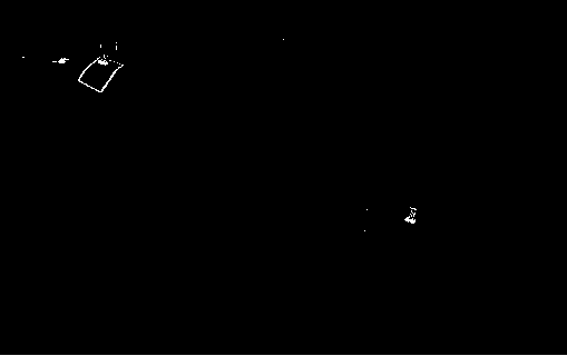
[0076] refer to image 3 , and compared with step S11 in the technical plan, for the case where the area of ​​the survey area is small and one side of the mountain is connected to the plain, and the radius of the survey area is less than the maximum range of the UAV, further explanations are as follows:

[0077] image 3 Among them, Site 1 and Site 2 are farmlands that have just been plowed, with mountains on the east and plains on the west, and the length is more than 50 meters and the width is more than 30 meters. When surveying the terrain in the eastern mountainous area, you can choose location 1 or location 2 according to the wind direction at the time of takeoff. There is an east-west path in the middle of location 1, which is not long enough for north-south take-off and landing. According to the principle that drones need to take off and land against the wind, you can choose location 1 when the wind direction is westerly when taking off. When the wind is east, due to ...

Embodiment 2

[0079] refer to Figure 4 , and compared with step S13 in the technical plan, for the situation that there is no plain around the survey area and the area is large, and the drone takes off from outside the survey area and cannot complete the aerial survey task of the entire survey area, further explanations are as follows:

[0080] Site 3 is located in a long and narrow valley. The mountains on the west side are relatively gentle and the mountains on the east side are steep. In order to ensure the safe take-off and landing of drones, the length of the landing site is required to be increased to 100 meters, and the width requirement is increased to 50 meters. The bottom of the valley is flat and there is no river. and gravel etc. The wind in the valley is often strong, and it is necessary to ensure that the wind level in the valley is below level 3 before the drone can take off and land. According to the wind direction, you can choose to take off and land in the east or west o...


PUM


Abstract

The invention belongs to the technical field of UAV (unmanned aerial vehicle) aerial survey, and relates to the fixed wing UAV taking-off and landing technology, and the system comprises a database module, and also comprises a measurement area scope determination module, a field survey module, a data processing module, and an aerial survey updating reminding module, wherein the measurement area scope determination module, the field survey module, the data processing module and the aerial survey updating reminding module are connected in sequence. The method comprises a pre-selection step, a step of determining a better taking-off and landing region, and a step of determining an optimal taking-off and landing point. The system and method are high in real-time performance and efficiency, arehigh in precision, are good in control degree, have a dedicated selection step for the fixed wing UAV, quickly achieve the highly precise selection of the taking-off and landing place in a severe andcomplex mountainous region, greatly improve the UAV aerial survey precision, guarantee the safe taking-off and landing of the UAV, greatly reduce the aerial survey cost of the UAV, and are more suitable for popularization.

Description

technical field [0001] The invention belongs to the technical field of unmanned aerial vehicle surveying, and relates to the take-off and landing technology of a fixed-wing unmanned aerial vehicle, and more specifically, relates to a selection method for a system for selecting take-off and landing points of a fixed-wing unmanned aerial vehicle in mountainous areas. Background technique [0002] As we all know, fixed-wing UAVs have a wide range of aerial surveys, high speed, and high efficiency. Harsh. Trimble UX5 UAV needs a flat land with a length of at least 50 meters and a width of 30 meters. It is best to choose a field that is open, relatively soft and free of hard objects such as stones, and try to avoid hard landing on cement roads. When performing surveying and mapping tasks, it is inevitable to encounter more complex terrain conditions, and it is impossible to find a large area of ​​open space, which is extremely unfavorable for the safe landing of drones. In moun...

Claims


Application Information

Patent Timeline
Patent Type & Authority Patents(China)
IPC IPC(8): G05D1/10G06Q10/04G06Q50/30
CPCG06Q10/04G06Q10/0631
Inventor 王博魏怀斌范天雨张颜丁振宇聂相田
Owner NORTH CHINA UNIV OF WATER RESOURCES & ELECTRIC POWER
Why Eureka
Try Eureka