Police three-dimensional GIS data intelligent application system

An application system and data acquisition system technology, which is applied in the field of police 3D GIS data intelligent application system, can solve the problems of poor positioning, low precision, low definition, etc., and achieve the effect of strong sense of precision, realistic application and high precision

Pending Publication Date: 2019-11-12
NANCHONG YUYUN INNOVATIVE TECH CO LTD
View PDF2 Cites 1 Cited by
  • Summary
  • Abstract
  • Description
  • Claims
  • Application Information

AI Technical Summary

Problems solved by technology

However, due to the insufficient positioning ability of the existing GIS in the three-dimensional space, the existing three-dimensional GIS system is actually two-dimensional or 2.5-dimensional, that is, it can only display the projected image in the vertical direction, but cannot display the heig

Method used


Image

  • Police three-dimensional GIS data intelligent application system

Examples


Embodiment Construction

[0012] The technical solutions in the embodiments of the present invention will be clearly and completely described below in conjunction with the accompanying drawings in the embodiments of the present invention. Obviously, the described embodiments are only a part of the embodiments of the present invention, rather than all the embodiments. Based on the embodiments of the present invention, all other embodiments obtained by those of ordinary skill in the art without creative work shall fall within the protection scope of the present invention.

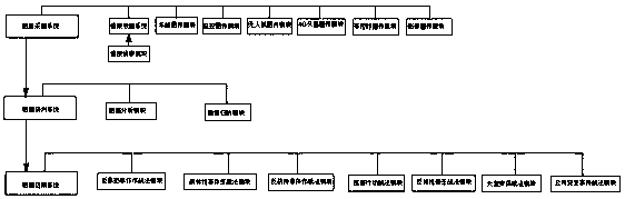
[0013] See figure 1 , An intelligent application system for police three-dimensional GIS data. The intelligent application system uses Skyline three-dimensional geographic information software to intelligently create three-dimensional interactive scenes and custom interfaces, and is interconnected with the police platform; the system is composed of a data acquisition system and data research and judgment System and data application syste...


PUM


Abstract

The invention discloses a police three-dimensional GIS data intelligent application system. The system is composed of a data acquisition system, a data research and judgment system and a data application system. According to the invention, air-ground information superposition, accurate alarm pushing, accurate force delivery and tactical application optimization can be realized, digital library building, integrated sensing and large-scale application are formed, and a new synthetic combat mode of large system integration, large data integration and large command pattern is realized. According to the invention, multi-modal video information, a tactical analysis model and three-dimensional GIS data are used as supports; the situation, the occurrence mechanism and the evolution rule of the important warning situation site can be mastered in advance; event causal relationships and corresponding disposal strategies are rapidly deduced, online study, judgment, deployment, command and supervision are rapidly completed, a new synthetic combat mode of 'front emergency disposal and background data support 'is formed, risk management and control and three-dimensional prevention are completed in advance, and the system is a new police basic support type actual combat product.

Description

Technical field [0001] The invention relates to the technical field of intelligent application of three-dimensional GIS data, in particular to an intelligent application system of three-dimensional GIS data for police. Background technique [0002] The concept of digital city refers to the establishment of a three-dimensional model of the city and assigning these three-dimensional model coordinate parameters for positioning. The proposal and promotion of the digital city concept greatly facilitates people's life and management. The geographic information system developed on the basis of the digital concept, referred to as GIS, refers to the collection, storage, management, retrieval, analysis and description of the location and distribution of spatial objects and related attribute data with the support of computer software and hardware. A computer system whose main task is to answer user questions. The GIS system can visually display geographic objects and has great application...

Claims


Application Information

Patent Timeline
IPC IPC(8): G06F16/29G06Q50/26
CPCG06F16/29G06Q50/26
Inventor 刘强易佳宁
Owner NANCHONG YUYUN INNOVATIVE TECH CO LTD
Why Eureka
Try Eureka