True three-dimensional aerial remote sensing geological interpretation method in engineering geological investigation

A technology of engineering geology and aerial remote sensing, applied in the directions of surveying, mapping and navigation, measuring devices, instruments, etc., can solve the problems of restricting the use of aerial remote sensing images, difficult to locate and find the interpretation target image, and cumbersome to translate the interpretation results. The effect of field carrying, improved convenience, and improved accuracy

Active Publication Date: 2011-09-07
CHINA RAILWAY FIRST SURVEY & DESIGN INST GRP
View PDF4 Cites 9 Cited by
  • Summary
  • Abstract
  • Description
  • Claims
  • Application Information

AI Technical Summary

Problems solved by technology

However, in terms of interpretation methods, the stereoscopic interpretation mode based on paper black and white image pairs is generally used. Most of them only perform fixed-scale stereoscopic observation and interpretation of aerial image pairs. The drawing is cumbersome and the accuracy is poor, which restricts the effective use of aerial remote sensing images to a certain extent.

Method used


Image

  • True three-dimensional aerial remote sensing geological interpretation method in engineering geological investigation
  • True three-dimensional aerial remote sensing geological interpretation method in engineering geological investigation

Examples


Embodiment Construction

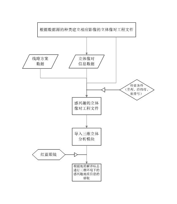
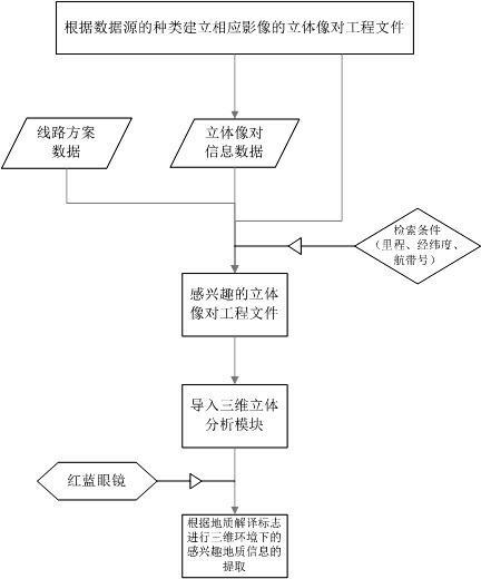
[0023] see figure 1 , the establishment of a true 3D geological interpretation environment for aerial images is carried out in accordance with the following steps:

[0024] (1) Establishment of stereoscopic image pair project files: the photo data obtains the time-space attitude at the moment of photo shooting through soft copy, establishment of camera files, image matching, and calculation of spatial coordinates, and then obtains measurement and measurement through joint measurement and mapping of on-the-spot photos. According to the coordinate information of the image control point, the corresponding stereo image pair project file is established; the aerial digital image data is calculated and established by the digital photogrammetry workstation according to the RPC parameter model of the stereo image pair provided by its sensor.

[0025] (2) Generate a stereo pair database file: extract the image pair information of the stereo pair file according to the control point files...


PUM


Abstract

The invention relates to a true three-dimensional aerial remote sensing geological interpretation method in engineering geological investigation. In interpretation measures, aerial remote sensing images are generally interpreted based on a stereoscope interpretation mode of papery black and white image pairs, in most of the interpretation measures, only stereoscopic observation interpretation in fixed scale is performed on the aerial image pairs, interpreted target image pairs are difficult to position and search, rendition of interpretation result is complex and inaccurate, and effective utilization of the aerial remote sensing images is constrained. In the method, aiming at a digital photogrammetry single stereoscopic image pair, a digital remote sensing geological true three-dimensional interpretation environment is created, so that a remote sensing geological interpretation method is improved, and accuracy of extraction of geological information is improved. With the method provided by the invention, the transformation from a two-dimensional plane to the three-dimensional environment in the geological information interpretation process is implemented; in the geological information interpretation process, a full digital interpretation environment is implemented; the three-dimensional environment is created based on a red-and-blue glasses mode, requirements on software and hardware environments are simplified, hardware devices are portable for field operation, and convenience for field work is also improved.

Description

Technical field: [0001] The invention relates to the field of engineering geological survey, in particular to a true three-dimensional aerial remote sensing geological interpretation method in engineering geological survey. Background technique: [0002] The interpretation process of engineering geological information is the process of extracting interesting information from remote sensing images according to the image interpretation signs of various geological phenomena. The interpretation methods have developed from visual qualitative interpretation, static interpretation to computer remote sensing image processing. Human-computer interactive interpretation that combines qualitative and quantitative, static and dynamic methods with geographic information systems and other means. As an important data source for engineering geological interpretation, aerial remote sensing images have attracted extensive attention from engineers and technicians due to their high resolution an...

Claims


Application Information

Patent Timeline
Patent Type & Authority Applications(China)
IPC IPC(8): G01C11/00
Inventor 任晓春孟祥连张占忠刘亚林宋明辉王海英
Owner CHINA RAILWAY FIRST SURVEY & DESIGN INST GRP
Why Eureka
Try Eureka