Inland water body optical classification method based on medium-resolution imaging spectrometer (MERIS) full-resolution image data

An image data, full-resolution technology, applied in the field of remote sensing, can solve problems such as insufficient atmospheric correction and optical classification, and achieve the effect of improving accuracy

Inactive Publication Date: 2013-03-06
SATELLITE ENVIRONMENT CENT MINIST OF ENVIRONMENTAL PROTECTION +1
View PDF5 Cites 11 Cited by
  • Summary
  • Abstract
  • Description
  • Claims
  • Application Information

AI Technical Summary

Problems solved by technology

[0005] These studies have achieved some results, but for inland highly turbid and eutrophic water bodies, insufficient consideration has been given to atmospheric correction and optical classification

Method used


Image

  • Inland water body optical classification method based on medium-resolution imaging spectrometer (MERIS) full-resolution image data
  • Inland water body optical classification method based on medium-resolution imaging spectrometer (MERIS) full-resolution image data
  • Inland water body optical classification method based on medium-resolution imaging spectrometer (MERIS) full-resolution image data

Examples


Embodiment Construction

[0047] The specific implementation manners of the present invention will be further described in detail below in conjunction with the accompanying drawings and embodiments. The following examples are used to illustrate the present invention, but are not intended to limit the scope of the present invention.

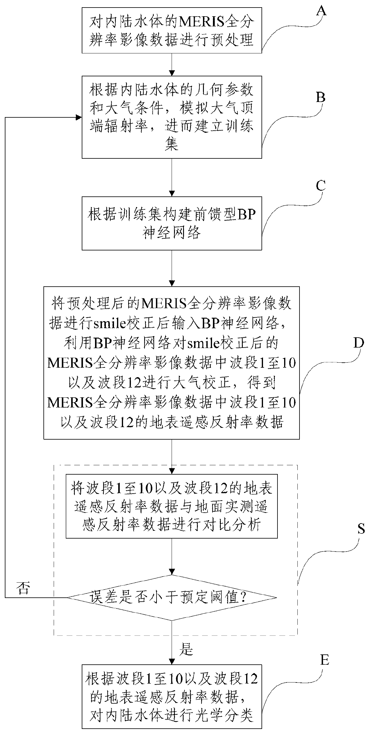
[0048] In this embodiment, taking Taihu Lake as an example of an inland water body, the process of further classifying local water bodies in Taihu Lake is described in detail. figure 1 It is a flow chart of the method for optical classification of inland water bodies based on MERIS full-resolution image data described in the embodiment of the present invention, as shown in figure 1 Said, said method comprises the steps of:

[0049] A: Preprocessing the MERIS full-resolution image data of inland water bodies.

[0050]Described step A specifically comprises the steps:

[0051] A1: Obtain MERIS full-resolution image data with the date corresponding to the field measured da...


PUM


Abstract

The invention discloses an inland water body optical classification method based on medium-resolution imaging spectrometer (MERIS) full-resolution image data and relates to the technical field of remote sensing. The method comprises the following steps of: preprocessing the MERIS full-resolution image data of an inland water body; simulating atmosphere top radiance, and establishing a training set; establishing a feed-forward BP neural network, performing atmosphere correction on the wave bands 1-10 and a wave band 12 in the MERIS full-resolution image data subjected to smile correction by utilizing the BP neural network so as to obtain earth's surface remote sensing reflectivity data of the wave bands 1-10 and the wave band 12 in the MERIS full-resolution image data; and performing optical classification on the inland water body according to the earth's surface remote sensing reflectivity data of the wave bands 1-10 and the wave band 12. According to the method, the local water body in the inland water body is classified, and a data support is provided for improving the remote sensing inversion precision and establishing a unified inversion model for a water body with the same optical characteristics.

Description

technical field [0001] The invention relates to the field of remote sensing technology, in particular to an optical classification method for inland water bodies based on full-resolution image data of MERIS (The Medium Resolution Imaging Spectrometer). Background technique [0002] Inland water bodies are key factors for maintaining ecological balance and ensuring water supply for people around water bodies. Take Taihu Lake as an example. It is the third largest freshwater lake in China. Taihu Lake plays an important role in supplying water to surrounding lakeside cities. But in recent years, the pollution of Taihu Lake has become more and more serious, and eutrophication has appeared. Serious threat to the natural ecological function of Taihu Lake. Therefore, regular monitoring of water bodies becomes inevitable. [0003] In the same water body, the remote sensing albedo will vary with the composition of the water body. For example, some areas of Taihu Lake may be mainly...

Claims


Application Information

Patent Timeline
Patent Type & Authority Applications(China)
IPC IPC(8): G06F17/50
Inventor 王桥李云梅李渊吕恒
Owner SATELLITE ENVIRONMENT CENT MINIST OF ENVIRONMENTAL PROTECTION
Why Eureka
Try Eureka