Electronic map making method based on basic geographic information data

A basic geographic information and electronic map technology, applied in the field of electronic map drawing, to achieve the effect of easy expansion and maintenance, and reduce processing workload

Inactive Publication Date: 2014-04-30
WUHAN UNIV
View PDF14 Cites 19 Cited by
  • Summary
  • Abstract
  • Description
  • Claims
  • Application Information

AI Technical Summary

Problems solved by technology

[0007] The present invention mainly solves the problems existing in the prior art, such as the human and material costs caused by the heterogeneous and heterogeneous electronic map data format and organizational form, symbols and annotation shifts in the configuration process, etc.; it provides a Electronic map mapping method based on basic geographic information data under the guidance of knowledge base and template library design

Method used


Image

  • Electronic map making method based on basic geographic information data
  • Electronic map making method based on basic geographic information data
  • Electronic map making method based on basic geographic information data

Examples


Embodiment Construction

[0035] In order to facilitate those skilled in the art to understand and implement the present invention, the present invention will be further described in detail below in conjunction with the accompanying drawings and embodiments.

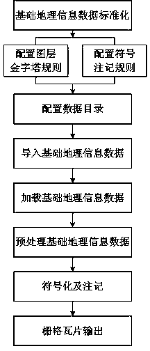
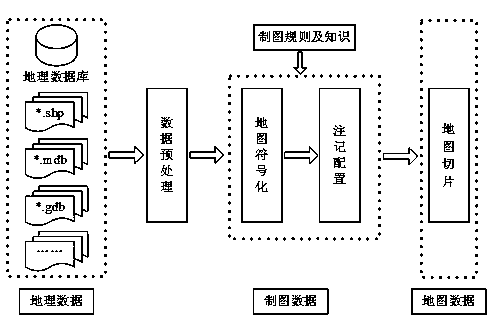
[0036] please see figure 1 , the technical scheme adopted in the present invention is: a kind of electronic map drawing method based on basic geographical information data, comprises the following steps:

[0037] Step 1: Standardize the basic geographic information data; its specific implementation includes the following sub-steps:

[0038] Step 1.1: Unify the data format of the basic geographic information data, wherein the basic geographic information data format of multiple maps of the same scale must be the same, and the basic geographic information data format between different scales can be different;

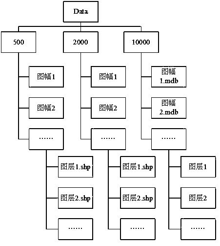
[0039] Step 1.2: Unify the layer organization level of the basic geographic information data under the same scale;

[0040] Step 1.3: Uni...


PUM


Abstract

The invention discloses an electronic map making method based on basic geographic information data. The method includes the main steps that the basic geographic information data are standardized; pyramid principles of symbols and notes are configured; a basic geographic information data category is configured; basic geographic information data are imported; symbolization and note configuration are carried out according to the pyramid principles of the symbols and notes; grid tiles of an electronic map are exported. The method is easy to carry out and high in configuration efficiency and can meet requirements for making ordinary grid-type electronic maps.

Description

technical field [0001] The invention belongs to an electronic map drawing method, and relates to a method for making an electronic map, in particular to an electronic map drawing method based on basic geographic information data. [0002] Background technique [0003] The carrier of traditional maps is mostly paper. With the development of science and technology, electronic maps have appeared. Electronic map, that is, digital map, is a map that is stored and consulted digitally using computer technology. The electronic map drawing system and method are important systems for geographic information visualization. By using computer graphics and image processing technologies, map information is presented electronically, expressed intuitively and visually, and stored as a computer-recognizable image. Data Format. Usually, the production of electronic maps requires a lot of manpower and material resources. Therefore, producers of electronic maps always hope to complete the prod...

Claims


Application Information

Patent Timeline
Patent Type & Authority Applications(China)
IPC IPC(8): G06F17/30
CPCG06F16/29
Inventor 李霖于忠海朱海红尹章才应申
Owner WUHAN UNIV
Why Eureka
Try Eureka