Geocoding method and geocoding system based on smart city

A geocoding and urban technology, applied in the direction of electrical digital data processing, special data processing applications, instruments, etc., can solve the problems of poor interactivity of map components, difficult interface design, and difficult user use, etc., to achieve friendly interface and scalability Strong, powerful effects

Active Publication Date: 2015-11-04
TAIHUA WISDOM IND GRP CO LTD
View PDF2 Cites 20 Cited by
  • Summary
  • Abstract
  • Description
  • Claims
  • Application Information

AI Technical Summary

Problems solved by technology

[0003] However, at present, the smart urban management geocoding system has a single function, poor interactiv...

Method used


Image

  • Geocoding method and geocoding system based on smart city
  • Geocoding method and geocoding system based on smart city

Examples


Embodiment Construction

[0048] The present invention will be described in detail below in conjunction with the drawings:

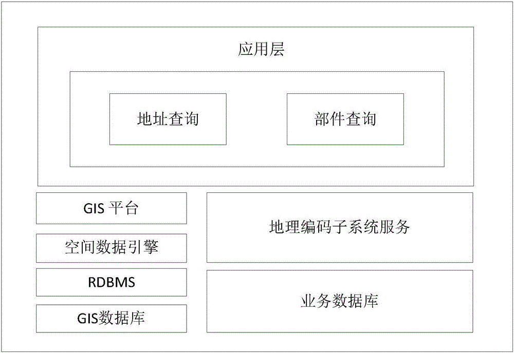
[0049] Such as figure 1 As shown, the embodiment of the composition architecture of the smart urban management geocoding system of the present invention is illustrated, which specifically includes:

[0050] The application layer includes, but not limited to, address query and component query functions; the function of address query and component query is realized by calling related services of the GIS platform and geocoding subsystem.

[0051] Geocoding subsystem services provide responsibility area information, component type information, etc.

[0052] The business database stores responsibility area information, zoning information, component type information, etc.

[0053] The Geographical Information System (GIS) platform provides a wealth of GIS functions, such as maps, locators, and software objects used in central server applications. For example, ArcGIS Server is a platform for buil...


PUM


Abstract

The invention discloses a geocoding method and a geocoding system based on smart city. The method comprises the following steps of: acquiring geographic data information, area of responsibility information, area division information and part type information, and storing the acquired information in corresponding databases; reading the area of responsibility information, the area division information and the part type information by a relational database management system and a spatial data engine, and showing the information on a GIS (Geographical Information System) platform; selecting a query part type and a query area or an address query, and calling a GIS service platform and a geocoding subsystem service to complete corresponding request results. According to the invention, the geocoding adopts a mature ArcGIS platform, which has advanced, safe and steady technology, powerful functions and high scalability.

Description

Technical field [0001] The invention relates to a digital smart city, in particular to a geocoding method and system based on a smart city. Background technique [0002] The geocoding system is one of the most important supporting systems for digital city management. Geocoding technology can assign geographic coordinates to information resources with geographic locations. Through geocoding, the city’s existing addresses can be spatialized, digitized and standardized. Establishing a corresponding relationship with the actual space location of the address, realizing the relative positioning of the address space, can make various data resources in the city reflect the space location through the address information, and improve the readability of the space information. [0003] However, at present, the smart urban management geocoding system has a single function, poor interactivity of map components, and interface design that is not easy to operate, which causes difficulties for users...

Claims


Application Information

Patent Timeline
IPC IPC(8): G06F17/30
Inventor 马述杰谭文时念武魏巍周永利洪之旭董吉臣刘海明
Owner TAIHUA WISDOM IND GRP CO LTD
Why Eureka
Try Eureka