A method of building a three-dimensional map

A technology of three-dimensional maps and two-dimensional images, which is applied in image enhancement, image analysis, 3D modeling, etc., can solve the problems of large errors and low positioning accuracy, and achieve the effects of low cost, avoiding wrong matching, and overcoming image matching confusion

Pending Publication Date: 2018-12-25
SHANTOU UNIV
View PDF3 Cites 17 Cited by
  • Summary
  • Abstract
  • Description
  • Claims
  • Application Information

AI Technical Summary

Problems solved by technology

It can solve the problems of low positioning accuracy and large error of mobile robots in the indoor navigation process

Method used


Image

  • A method of building a three-dimensional map
  • A method of building a three-dimensional map
  • A method of building a three-dimensional map

Examples


Embodiment Construction

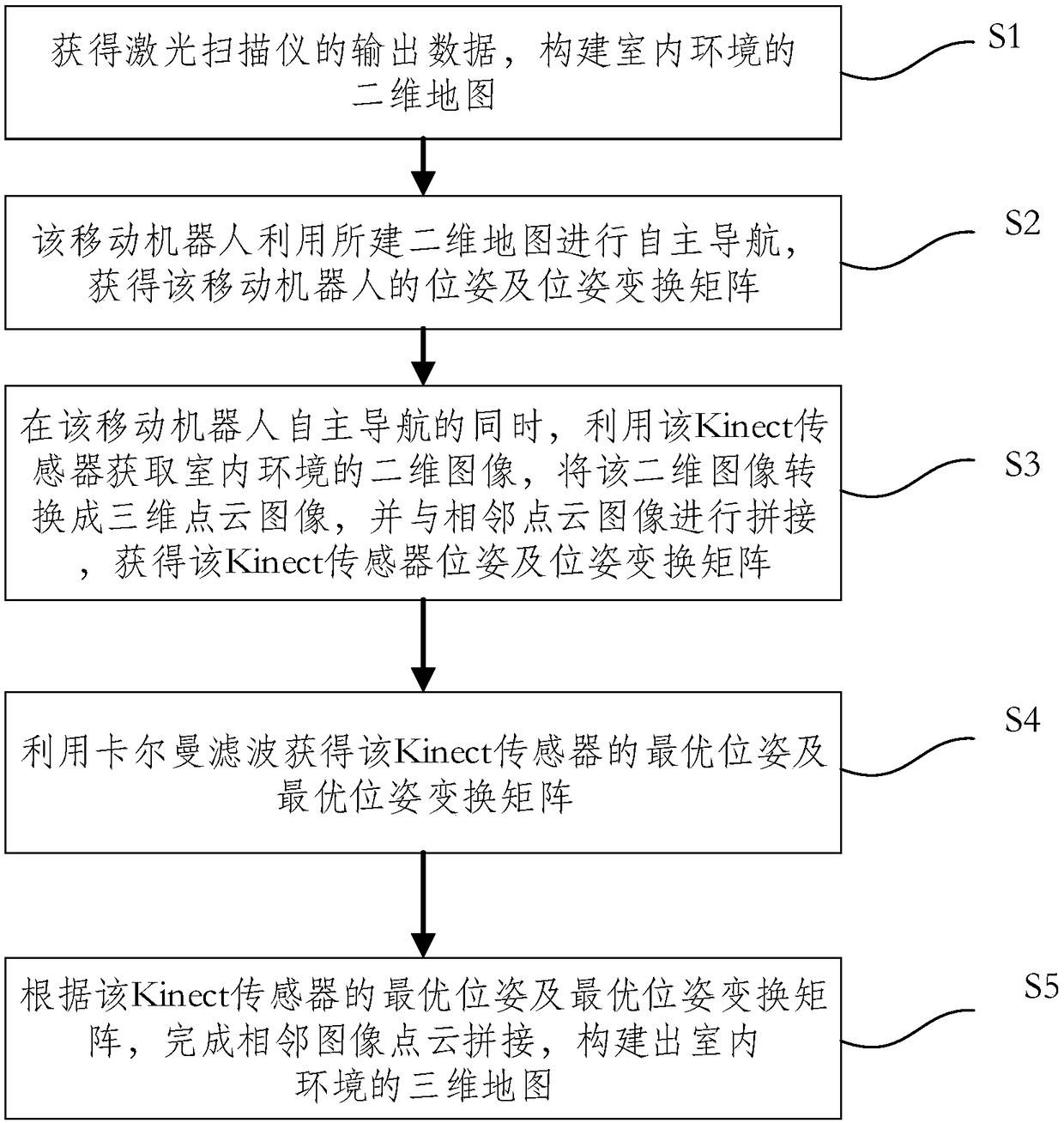
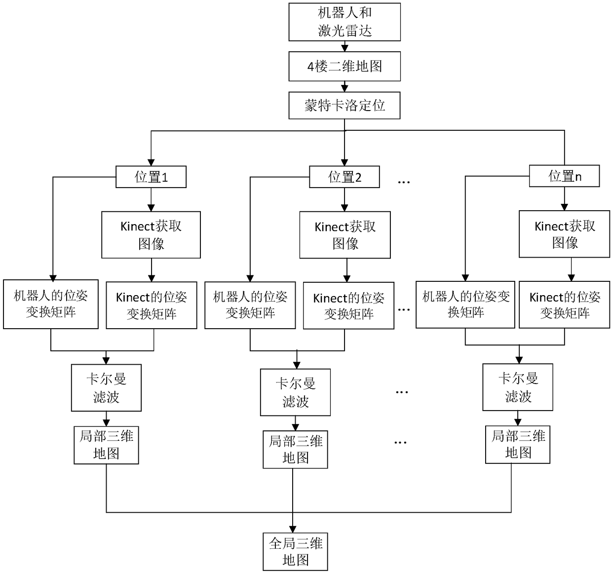
[0028] In order to make the object, technical solution and advantages of the present invention clearer, the present invention will be further described in detail below in conjunction with the accompanying drawings.

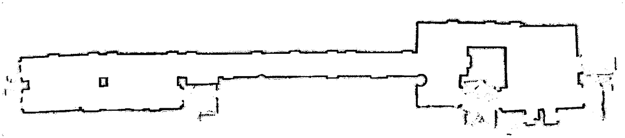
[0029] The experimental environment of the embodiment of the present invention is the corridor of a certain experimental building, the indoor environment of offices and laboratories. In this embodiment, the mobile robot explores the public areas of the floors.

[0030] Use TurtleBot mobile robot in the present embodiment, on this mobile robot, wheel encoder, laser scanner and Kinect sensor are installed, in the present embodiment, this laser scanner is Rplidar laser radar, and the scanning range of this Rplidar laser radar is 360°, the maximum measuring distance is 6 meters. The implementation system adopted is the Ubuntu system, and the ROS system platform and Arduino development board are built, and the Opencv open source software is used to realize it with C++...


PUM


Abstract

The embodiment of the invention discloses a method for constructing a three-dimensional map, which comprises the following steps: output data of a laser scanner is obtained, and a two-dimensional mapof an indoor environment is constructed; the mobile robot uses the two-dimensional map to carry out autonomous navigation, and obtains the posture and the posture transformation matrix of the mobile robot; at the same time of autonomous navigation of the mobile robot, the kinect sensor is used to acquire two-dimensional images of the indoor environment, the two-dimensional images are converted into three-dimensional point cloud images, and the images are mosaic with neighboring point cloud images to obtain the kinect sensor posture and posture transformation matrix; the optimal posture and theoptimal posture transformation matrix of the Kinect sensor are obtained by Kalman filter. According to the optimal posture and the optimal posture transformation matrix of the Kinect sensor, the image mosaic of adjacent point cloud is completed, and the 3D map of indoor environment is constructed. By adopting the invention, the positioning accuracy of the mobile robot in the indoor navigation process is improved, the mismatch of the image mosaic is avoided, and the chaotic phenomenon of the image matching in the repetition area is overcome.

Description

technical field [0001] The invention relates to a method for constructing an indoor environment map, in particular to a method for constructing a three-dimensional map based on the fusion of Monte Carlo positioning and a feature point method under a two-dimensional map. Background technique [0002] With the rapid development of computer technology, satellite positioning system and Internet technology, indoor environment composition and positioning technology have been widely used in real life. At present, the problem of map construction in indoor environments has become a hot field. Although the method of building a two-dimensional map based on lidar is relatively mature and complete, it cannot obtain the real three-dimensional shape of the object, only a plane can be obtained, making positioning not effectively. [0003] At present, in the indoor 3D map construction method, it is more popular to use feature points to estimate camera motion (feature point method) and to ca...

Claims


Application Information

Patent Timeline
Patent Type & Authority Applications(China)
IPC IPC(8): G06T17/05G06T3/40G01C21/20
CPCG06T3/4038G06T17/05G01C21/206G06T2207/10028
Inventor 范衠李冲朱贵杰卞新超陈文钊邱本章游煜根胡星晨
Owner SHANTOU UNIV
Why Eureka
Try Eureka