An area denial method for navigation and links of civilian low-slow and small unmanned aerial vehicles

A UAV, low-slow and small technology, applied in the directions of interference to communications, vehicle wireless communication services, and location-based services, etc., can solve the problems of short detection distance, landing, and high false alarm rate.

Active Publication Date: 2021-06-15
SOUTHWEST CHINA RES INST OF ELECTRONICS EQUIP
View PDF5 Cites 0 Cited by
  • Summary
  • Abstract
  • Description
  • Claims
  • Application Information

AI Technical Summary

Problems solved by technology

Because of its low, slow and small characteristics, civilian drones are not easily detected by radar, and there are also problems of high false alarm rate and short detection distance in the process of radar detection
At this stage, the UAV countermeasures that have been proposed include: the area denial method of driving away false navigation signals, and the measurement and control link of the UAV has not been blocked or affected, so that malicious flight controllers can still control the UAV. Disadvantages of human-machine reconnaissance or attack on important areas; the technical means of suppressing navigation and telemetry signals with high power can only rely on reliable detection means to find UAVs, and can only make UAVs descend vertically and cannot land on them. specified location

Method used


Image

  • An area denial method for navigation and links of civilian low-slow and small unmanned aerial vehicles
  • An area denial method for navigation and links of civilian low-slow and small unmanned aerial vehicles
  • An area denial method for navigation and links of civilian low-slow and small unmanned aerial vehicles

Examples


Embodiment Construction

[0019] The present invention will be further described below in conjunction with the accompanying drawings.

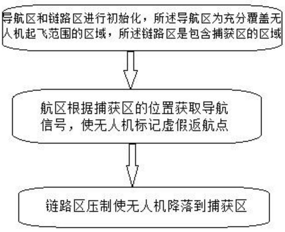
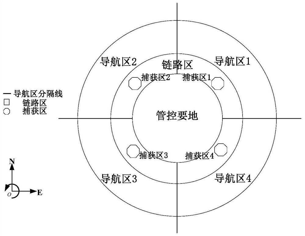
[0020] Such as figure 1 As shown in , a flow diagram of an area denial method for the navigation and link of civilian low-slow small unmanned aerial vehicles, as shown in figure 2 As shown, the scope of the system is divided into the following areas according to the functions: navigation area, link area, capture area and important control areas.

[0021] Capture area: The capture area is the designated area to capture the drone, and at the same time, the navigation signal corresponding to the navigation area should be generated according to the latitude and longitude coordinates of the capture area. In this embodiment, there is one capture area (capture area 1, capture area 2, capture area 3, capture area 4) in the four quadrants of coordinates.

[0022] Navigation area: as shown in the figure, the entire ring area is divided into 4 navigation areas (navigation area...


PUM


Abstract

The invention relates to the technical field of security defense, and discloses an area denial method for navigation and links of civilian low-slow small unmanned aerial vehicles. Including the following process: Step S1: the navigation area and the link area are initialized, the navigation area is an area that fully covers the take-off range of the drone, and the link area is an area that includes the capture area; Step S2: the navigation area is based on the capture Obtain the navigation signal at the location of the zone, so that the UAV marks a false home point; Step S3: Suppression of the link zone makes the UAV land in the capture zone. The technical solution of the present invention can capture indiscriminately. The civilian unmanned aerial vehicle that takes off in the navigation area avoids the missed capture situation caused by the detection of the unmanned aerial vehicle, and improves the reliability of the system; the flight route of the technical solution of the present invention does not pass through The sky above the protected important place prevents the threat of secondary attack and improves the security; the technical solution of the invention can capture multiple batches and a large number of different types of unmanned aerial vehicles at the same time, and has high efficiency.

Description

technical field [0001] The invention relates to the technical field of security defense, in particular to an area denial method for navigation and links of civilian low-slow small unmanned aerial vehicles. Background technique [0002] The intrusion protection of small civilian drones has become the top priority of the protection of important places. At present, the existing navigation control methods for low-speed and small civilian drones generally only interfere with the navigation signal of the drone. Since the measurement and control link of the drone has not been blocked or affected, malicious flight controllers can still Control drones to conduct reconnaissance or attack on important areas. In addition, the undifferentiated navigation signal suppression method generally used in the existing technology makes it impossible for the protected key areas to receive real navigation and positioning signals, especially for important areas such as airports that rely heavily on...

Claims


Application Information

Patent Timeline
Patent Type & Authority Patents(China)
IPC IPC(8): H04W4/021H04W4/024H04W4/029H04W4/40H04K3/00
CPCH04K3/82H04K2203/22H04W4/021H04W4/024H04W4/029H04W4/40
Inventor 刘博李鹏程李津何中翔
Owner SOUTHWEST CHINA RES INST OF ELECTRONICS EQUIP
Why Eureka
Try Eureka