Line detector for constant geo-element resolution earth remote sensing

A resolution and constant field element technology, applied in the field of in-line detectors, can solve the problems of two-channel index difference, image deformation processing inconsistency, etc., and achieve the effect of simplifying geometric correction algorithm, good market application prospect, and wide application range

Active Publication Date: 2019-03-19
SHANGHAI AEROSPACE CONTROL TECH INST
View PDF5 Cites 2 Cited by
  • Summary
  • Abstract
  • Description
  • Claims
  • Application Information

AI Technical Summary

Problems solved by technology

In 2015, Nuctech Technology Co., Ltd. applied for a patent for "a rotating arc detector box for X-ray inspection equipment", such as Figure 8 , which can solve the problems of the difference between the two channel indicators, the inconsistency of image deformation processing, and the simplification of geometric correction.

Method used


Image

  • Line detector for constant geo-element resolution earth remote sensing
  • Line detector for constant geo-element resolution earth remote sensing
  • Line detector for constant geo-element resolution earth remote sensing

Examples


Embodiment Construction

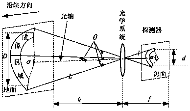
[0030] A new type of linear array detector for earth remote sensing with constant earth element resolution can improve the problem of energy loss caused by using traditional area array detectors based on constant earth element resolution optical imaging. When push-broom imaging of traditional remote sensing satellite line array detectors, the optical image resolution has the problem of non-uniform resolution, such as figure 1 As shown, h is the flight height, and S is the resolution directly below the detector. Since the observation inclination angle θ at the edge of the field of view is greater than the observation inclination angle at the center of the field of view, the resolution S' of the edge field of view is worse than S. Optical imaging systems with constant-dimensional resolution such as figure 2 As shown, assuming that the width of the imaging system to the ground is D, the optical distance from the center of the optical system to the imaging area is L, the angle f...


PUM


Abstract

The invention discloses a line detector for constant geo-element resolution earth remote sensing, aims to reach constant geo-element resolution earth remote sensing by reducing optical geometric deformation caused by a non-vanishing optical view field and earth curvature, and belongs to the field of earth remote sensing detectors. A detector crystal is provided with an arc special-shaped photo-etching model, so that the line detector can effectively solves the problem of loss of collected light energy caused by arc imaging discretization of an existing area array detector, and the collecting area of light energy is increased, so that light collecting ability of the detector is improved. In a whole view field, wave aberration of light waves received by an arc special-shaped detector is uniform, resolution is same, geometry deformation of the detector can be effectively reduced in remote sensing, so that a geometric correction algorithm is simplified, and the processing speed of a remotesensing image is further improved.

Description

technical field [0001] The invention relates to a line array detector used for earth remote sensing with constant earth element resolution, and belongs to the technical field of earth remote sensing detectors. Background technique [0002] Space remote sensing satellites can timely obtain optical information such as global clouds, fog, haze, wind direction, water vapor, ice, snow, water and land boundaries, ground temperature, ocean surface temperature, soil temperature and humidity, typhoon, etc., so as to be used for global disaster prevention and mitigation. [0003] At present, the large-field-of-view remote sensing cameras used by satellites, whether they are line arrays or area arrays, have a common problem of uneven ground resolution in optical images due to the non-zero optical field of view and the existence of the curvature of the earth. The Visible / Infrared Radiometer (VIIRS) in the US SNPP satellite (PM Obit) has a sub-satellite point resolution of 400m, and a sc...

Claims


Application Information

Patent Timeline
Patent Type & Authority Applications(China)
IPC IPC(8): G01C15/00
CPCG01C15/00
Inventor 刘玉娇李兴隆张少伟陈文
Owner SHANGHAI AEROSPACE CONTROL TECH INST
Why Eureka
Try Eureka