One-key point scheduling system and method based on police electronic map PGIS

An electronic map and subsystem technology, applied in the field of intelligent information, to achieve the effect of improving efficiency and rapid scheduling

Inactive Publication Date: 2019-11-08
四川新东盛科技发展有限公司
View PDF4 Cites 5 Cited by
  • Summary
  • Abstract
  • Description
  • Claims
  • Application Information

AI Technical Summary

Problems solved by technology

[0005] Aiming at the above-mentioned deficiencies in the prior art, the present invention provides a one-click system and method based on the police electronic map PGIS, which solves the problems of the public security organs in the horizontal and vertical cross-level, cross-region, cross-department, and cross-police types. 24 / 7 real-time fast video command issues

Method used


Image

  • One-key point scheduling system and method based on police electronic map PGIS
  • One-key point scheduling system and method based on police electronic map PGIS
  • One-key point scheduling system and method based on police electronic map PGIS

Examples


Embodiment

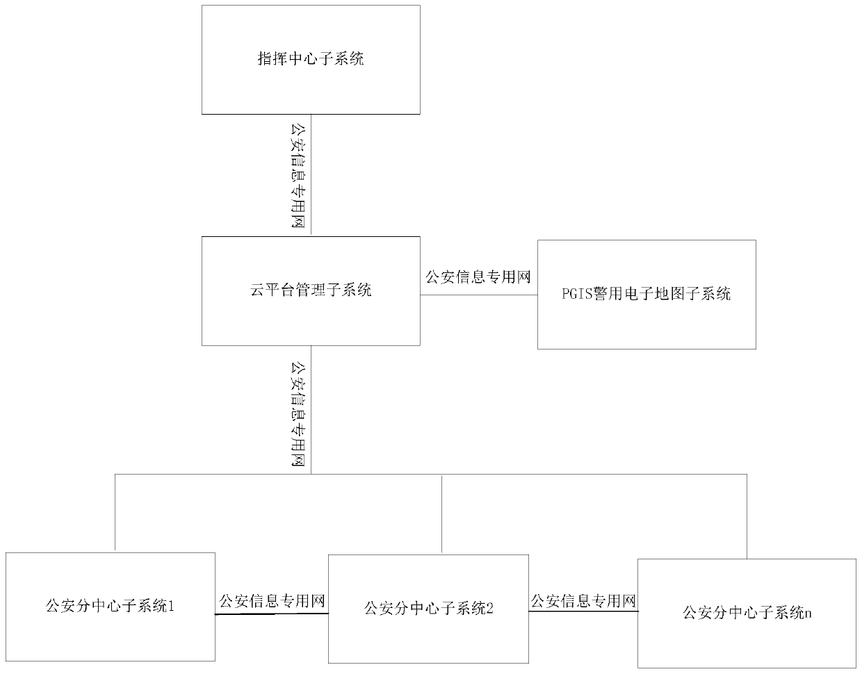
[0056] like figure 1 As shown, the present invention discloses a one-click system based on the police electronic map PGIS, including a command center subsystem, a cloud platform management subsystem connected to the command center subsystem, and a management subsystem connected to the cloud platform respectively. Several public security sub-center subsystems and PGIS police electronic map subsystems connected by the subsystems, the various public security sub-center subsystems are connected to each other, and the cloud platform management subsystem is used to store audio and video data, manage user information and Authenticate the equipment connected to the network, and monitor and deploy the video dispatching instructions issued by the command center subsystem or each public security sub-center subsystem; the command center subsystem is used to send the video dispatching instructions to the cloud platform management subsystem, Point-to-point or multi-point audio and video com...


PUM


Abstract

The invention provides a one-key point scheduling system and method based on a police electronic map PGIS, solving the problem of all-weather real-time rapid video command of public security organs intransverse and longitudinal cross-level, cross-region, cross-department and cross-police modes. According to the invention, flattening of public security commanding and dispatching work is realized;point-to-point, point-to-multipoint and multi-point rapid command cooperation among public security organs at all levels is satisfied; and application requirements of longitudinal and transverse rapidcommand cooperation, case research and judgment, daily work deployment, business training and the like between departments and police classes are met, and powerful support is provided for targets ofscientific decision making, rapid response, accurate defense management and control and the like of public security organizations, and the capability of rapid response and emergency handling of the public security organizations is effectively improved.

Description

technical field [0001] The invention belongs to the field of intelligent information technology, and in particular relates to a one-key point adjustment system and method based on the police electronic map PGIS. Background technique [0002] With the rapid development of society and economy, the work of public security organs to fight, defend, manage, and control has shown remarkable characteristics of cross-level, cross-departmental, and integrated command. Scheduling, case research and judgment, and intelligence information sharing have become the norm in daily police work. [0003] However, in the past, the public security video command and dispatch work mainly relied on the video conferencing system built by the provincial, city, and county public security organs. The networks at all levels are relatively independent and cannot be effectively integrated. Relying on the video conferencing system and carrying out command work through manual hierarchical transfer, the effi...

Claims


Application Information

Patent Timeline
Patent Type & Authority Applications(China)
IPC IPC(8): G06Q10/06G06Q50/26H04N7/18G06F16/29G06F3/14
CPCG06F3/1446G06F16/29G06Q10/06311G06Q50/26H04N7/181
Inventor 李成廖伟谭灏陈徐
Owner 四川新东盛科技发展有限公司
Why Eureka
Try Eureka