Coastal Dam Stability Monitoring and Inundation Vulnerability Assessment Method and System

A technology for evaluating systems and coastal zones, applied in radio wave measurement systems, satellite radio beacon positioning systems, measurement devices, etc. Accuracy and spatiotemporal resolution, ensuring accuracy and observation efficiency, and the effect of less manpower and capital investment

Active Publication Date: 2022-06-03
OCEAN UNIV OF CHINA
View PDF4 Cites 0 Cited by
  • Summary
  • Abstract
  • Description
  • Claims
  • Application Information

AI Technical Summary

Problems solved by technology

[0004] (1) Stability monitoring of coastal dams: the main technical methods include precision leveling, triangular elevation measurement, groundwater well monitoring technology, etc., which have the characteristics of high time resolution and high precision, but only limited discrete point observation, space Low resolution and small coverage, while continuous or periodic monitoring requires high manpower and material costs
[0005] (2) Spatial-temporal resolution and accuracy of coastal dam DEM: Most studies mainly consider the submerged range of a large area, so the DEM data used are often relatively low in spatial resolution and accuracy, and are not suitable for fine structure analysis. Inundation analysis of coastal dams
[0006] (3) Inundation vulnerability analysis of coastal dams: A common inundation analysis method is to use a uniform and constant deformation rate to derive the future DEM on the basis of the existing DEM. Most studies did not conduct DEM simulations, but transformed the deformation rate into Relative to the rise and fall of sea level, and assuming that the surface deformation rate is consistent in space and time, there are two obvious shortcomings in water level simulation. One is to use the average water level for inundation analysis, which weakens extreme weather events. damage under
Second, the water level estimate is too high, which amplifies the impact of inundation
[0008] (1) The stability monitoring of existing coastal dams can only be observed at limited discrete points, with low spatial resolution and small coverage. At the same time, continuous or periodic monitoring requires high manpower and material costs
[0009] (2) The temporal and spatial resolution and accuracy of the existing coastal dam DEM are relatively low, which is not suitable for fine-structure coastal dam inundation analysis
[0010] (3) There is no DEM simulation for the inundation vulnerability analysis of the existing coastal dams; the use of the average water level for inundation analysis or excessive water level estimation expands the impact of inundation
[0014] For problem (3), the existing dam inundation analysis does not predict the future DEM of the dam, but converts the dam deformation into the water level change, ignoring the destructive effect of the deformation itself on the dam structure, especially if there is When the vertical deformation is non-uniform, the shear stress generated is more likely to damage the dam and cause seawater intrusion and submersion of internal infrastructure

Method used


Image

  • Coastal Dam Stability Monitoring and Inundation Vulnerability Assessment Method and System
  • Coastal Dam Stability Monitoring and Inundation Vulnerability Assessment Method and System
  • Coastal Dam Stability Monitoring and Inundation Vulnerability Assessment Method and System

Examples


Embodiment Construction

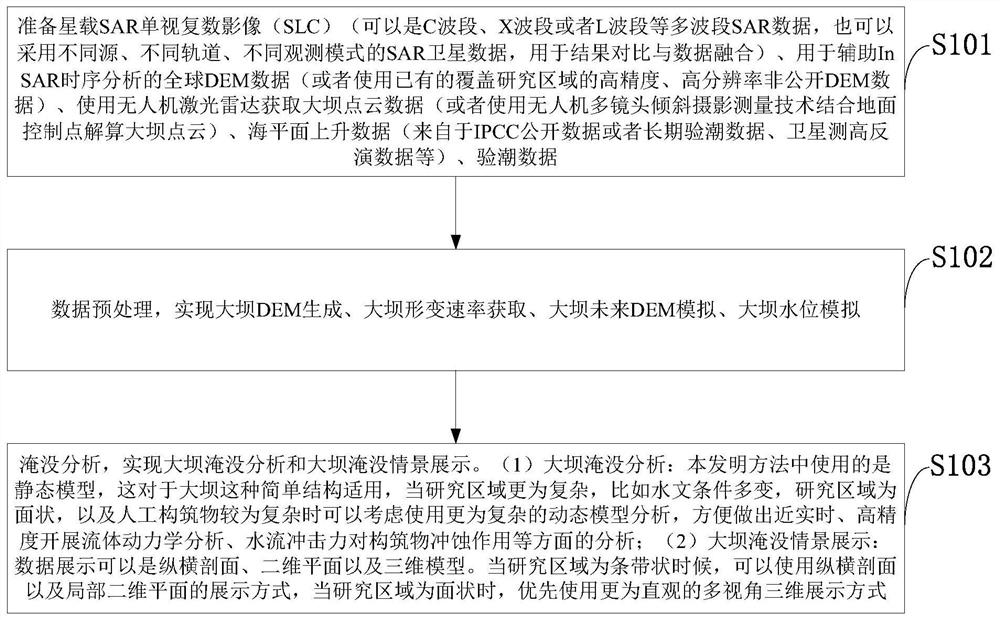
[0090] S103: Inundation analysis, realizing dam inundation analysis and dam inundation scenario display. (1) Dam inundation analysis: the present invention

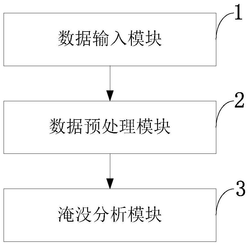
[0095] The submerged analysis module 3 is used to realize the dam inundation analysis and the dam inundation scenario display.

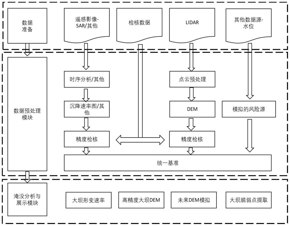
[0096] The technical scheme of the present invention is further described below in conjunction with the accompanying drawings.

[0100] (3) Point cloud: a collection of a large number of points that cover the ground surface and contain geometric location information and intensity information.

[0102] (5) Sea level rise: The melting of glaciers (not floes) caused by global warming causes global sea level rise.

[0103] (6) Bathtub Model: A simple model for hydrostatic submersion analysis.

[0109]

[0110]

[0111]

[0113] 2. Spaceborne radar interferometry and dam vertical deformation rate estimation, as shown in Figure 8.

[0128]

[0134] It should be noted that embodiments of the present invent...


PUM


Abstract

The invention belongs to the technical field of coastal dam monitoring, and discloses a coastal dam stability monitoring and inundation vulnerability assessment method and system, which prepare satellite-borne SAR single-view complex images and global DEM data for assisting InSAR time-series analysis , Use UAV lidar to obtain dam point cloud data, sea level rise data, and tide data; data preprocessing, realize dam DEM generation, dam deformation rate acquisition, dam future DEM simulation, dam water level simulation; Inundation analysis, realizing dam inundation analysis and display of dam inundation scenarios. The invention realizes the combination of spaceborne InSAR timing analysis deformation rate and unmanned aerial vehicle laser radar DEM, and ensures higher observation accuracy and temporal and spatial resolution. The invention realizes the synthesis of three components (tide component, storm water increase, and sea level rise) for submerged water level simulation, simultaneously simulates daily conditions and extreme conditions, and avoids excessively high water level estimation.

Description

Method and system for stability monitoring and inundation vulnerability assessment of coastal dams technical field The invention belongs to the coastal zone dam monitoring technical field, relate in particular to a kind of coastal zone dam stability monitoring and flooding There is no vulnerability assessment method or system. Background technique [0002] At present, coastal dam monitoring is usually affected by the spatial and temporal resolution of observation data, and is limited by manpower and economic cost. In general, use traditional ground leveling or satellite navigation and positioning systems (GNSS) to continuously operate the base Long-term deformation monitoring of dams at quasi-stations can achieve relatively high monitoring accuracy, but it is usually limited by the grid density and Economical Applicability. The current coastal zone dam inundation analysis can be mainly divided into two categories: the first category is based on the premise of stable...

Claims


Application Information

Patent Timeline
Patent Type & Authority Patents(China)
IPC IPC(8): G01S13/90G01S13/88G01S13/86G01S7/41G01S17/88G01S17/86G01S7/48G01S19/42
CPCG01S13/9023G01S13/865G01S13/885G01S7/41G01S17/88G01S17/86G01S7/4802G01S19/42Y02A10/40
Inventor 李鹏王国阳李振洪王厚杰
Owner OCEAN UNIV OF CHINA
Why Eureka
Try Eureka