Unmanned aerial vehicle simulation GPS signal positioning method and device

A technology of GPS signals and UAVs, applied in three-dimensional position/course control, vehicle position/route/altitude control, image data processing, etc., can solve the problem of low positioning accuracy, limited image acquisition environment, and blurred ground targets and other problems, to achieve the effect of solving positioning problems, improving anti-jamming ability, and real-time positioning of UAV position

Pending Publication Date: 2021-12-17
北京欧比邻科技有限公司
View PDF7 Cites 3 Cited by
  • Summary
  • Abstract
  • Description
  • Claims
  • Application Information

AI Technical Summary

Problems solved by technology

[0007] First, to solve the problem of short continuous battery life of drones; second, to solve the shortcomings of image acquisition environment restrictions, complex calculations, and low positioning accuracy in the positioning of drones using the optical flow method; third, to solve the shortcomings of using two-dimensional codes for drones The positioning method is limited by the complex outdoor lighting conditions and the low rising height of the UAV; Fourth, when the conventional UAV is operating at high altitude, the captured ground target is blurred or the target object cannot be identified, resulting in abnormal positioning or positioning of the UAV. The problem of inaccuracy; five, to solve the problem that the ground base station cannot provide support or restrict navigation under the premise of GPS signal

Method used


Image

  • Unmanned aerial vehicle simulation GPS signal positioning method and device
  • Unmanned aerial vehicle simulation GPS signal positioning method and device
  • Unmanned aerial vehicle simulation GPS signal positioning method and device

Examples


Embodiment Construction

[0030] The present invention will be further described below in conjunction with specific embodiments.

[0031] In order to make the purpose, technical solution and advantages of the present invention more clear. The technical solutions and advantages of the present invention will be clearly and completely described below in conjunction with the accompanying drawings of the present invention. Apparently, the described embodiments are only some of the embodiments of the present invention, but not all of them. Based on the embodiments of the present invention, all other embodiments obtained by persons of ordinary skill in the art without making creative efforts belong to the protection scope of the present invention.

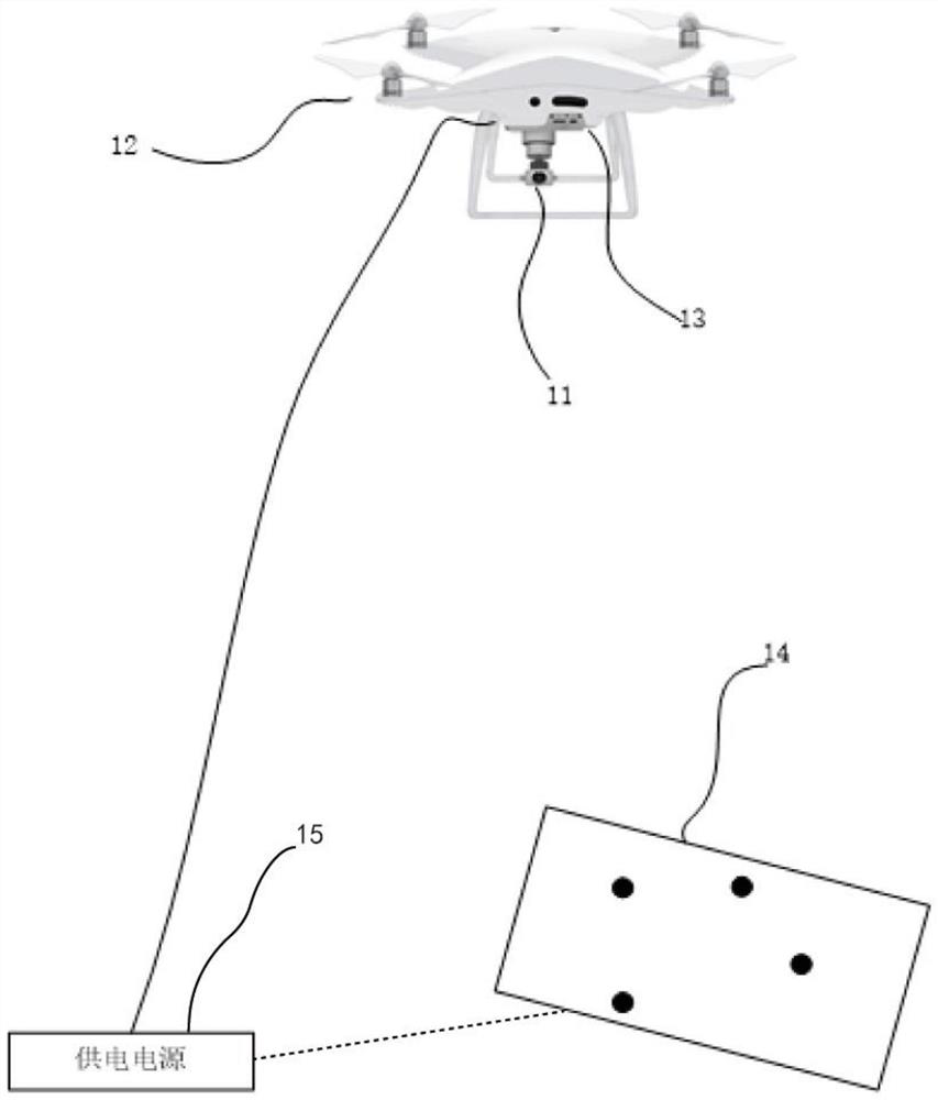
[0032] figure 1 It is a schematic diagram of the system structure of an unmanned aerial vehicle simulating GPS signal positioning in the present invention.

[0033] see figure 1 , a device for simulating a GPS signal by an unmanned aerial vehicle illustrated i...


PUM


Abstract

The invention discloses an unmanned aerial vehicle simulation GPS signal positioning method and device. The method specifically comprises the steps of S1, arranging a plurality of recognizable mark points (14) on the ground in a preset mode; S2, calibrating a monocular camera (11), and collecting double-frame images of the plurality of identifiable mark points (14) on the ground; S3, performing differential processing on the acquired double-frame image, and extracting two-dimensional coordinate points of the ground image; S4, calculating the positions and postures of the plurality of recognizable mark points (14) of the monocular camera (11) relative to the ground through a PNP algorithm; S5, converting the position information into latitude, longitude and altitude information; and S6, sending the simulated NMEA0183 protocol GPS signal containing the latitude and longitude information and the altitude information to a mooring unmanned aerial vehicle (12). According to the scheme, the defects that the endurance time of an existing unmanned aerial vehicle is short, GPS navigation positioning is easily interfered by factors such as light and the like, and the positioning distance is short can be overcome.

Description

technical field [0001] The invention relates to the field of optical positioning of unmanned aerial vehicles, in particular to a method and device for simulating GPS signal positioning of unmanned aerial vehicles. Background technique [0002] At present, rotor UAVs are developing rapidly and are widely used, and are increasingly used in military, disaster relief and other fields. However, some inherent characteristics of general drones also limit the application in some specific situations. For example, in the process of emergency rescue and disaster relief, if the base station on the ground is damaged, it is impossible to accurately locate the location information of the drone; generally, the drone has its own power supply, such as a battery or a fuel tank; it also has a wireless data transmission system and communication The system can control the flight in a large range, but the flight time is short. Moreover, the current drones use GPS navigation and positioning techn...

Claims


Application Information

Patent Timeline
Patent Type & Authority Applications(China)
IPC IPC(8): G01C11/04G01C11/30G05D1/10G06T7/73G06T7/80
CPCG01C11/04G01C11/30G05D1/101G06T7/73G06T7/80G06T2207/30244
Inventor 李金芝董锁芹
Owner 北京欧比邻科技有限公司
Why Eureka
Try Eureka