High precision surveillance system by means of multilateration of secondary surveillance radar (SSR) signals

a secondary surveillance radar and high-precision technology, applied in the direction of reradiation/reflection, measurement devices, radio wave reradiation/reflection, etc., can solve the problem of less precise location than single measurements, geometric dilution of precision, and shift of clocks, so as to improve estimation and improve efficiency. , to achieve the present level of air transport safety, the effect of improving the estimation

Active Publication Date: 2009-08-04
UNIVERSITY OF ROME TOR VERGATA
View PDF6 Cites 18 Cited by
  • Summary
  • Abstract
  • Description
  • Claims
  • Application Information

AI Technical Summary

Benefits of technology

[0023]The present invention exceeds, with original technical and architectural solutions, the limitations of MLAT systems pre-existing the invention itself and allows to considerably improve the operation both in terms of performance and in terms of reliability and continuity of the service.
[0024]In particular the limitations of the state of the art previous to the present invention are exceeded through: (a) a new measurement technique for the TOA (time of arrival) that allows to obtain much greater precision than the existing state of the art and is not limited from the frequency of the clocks of the measurement Stations, (b) the use, in each Station, of a simple clock, at low cost and free to deviate from the temporal reference of the central processing unit, in which the temporal data of the Station is estimated, with an original procedure, without the necessity of synchronizing it and without neither expensive (and complex) atomic clocks neither GPS receivers, one of which can however be used in the present invention in order to report the events to the “GPS Time” without introducing any critical consequence to safety and continuity of the service, (c) a new technique, based on multiple sources separation by means of algebraic signal processing, to discriminate superimposed SSR signals, and (d) the use on both non-recursive and recursive algorithms for the Multilateration function.
[0033]The use on both non-recursive and recursive algorithms for the Multilateration function, previous point (d), is useful as the non-linearity of the localization equations requires iterative procedures for the search of the optimal solutions. It is therefore important to choose algorithms able to guarantee the convergence, beyond the precision, and whose computational load is not excessive. In the preferred realization of the present invention, two algorithms in sequence are used. The first algorithm, non-recursive, initialises the estimation of the position while the second, recursive and based on the minimization of the quadratic error, improves the estimation until the required level of precision is reached.
[0034]The purpose of the present invention is to supply an advanced, second generation Multilateration system for locating and identifying cooperating mobiles, and a new method of location that allows the surveillance and the identification of aircraft and vehicles equipped with a standard SSR transponder or an equivalent device, in particular (but not exclusively) when these operate in the airport area and nearby it. Such a System is to traffic control avoiding, in particular, possible collisions. Thanks to this System, object of the present invention, the most stringent requirements of accuracy, continuity of service and integrity, are widely satisfied, with a remarkable increase of efficiency while maintaining, or increasing, the present levels of safety of the air transport also in adverse meteorological conditions and / or in case of high traffic.

Problems solved by technology

The shift of the clocks is an important problem: a shift of just three nanoseconds involves an error of ninety centimeters.
The solution suffers from a “geometric dilution of precision” known as DOP in the literature, that renders the location less precise than the single measurements in dependency of the geometry, that is of the relative position of the transponder and the stations.
DOP values can be, in some operating areas, rather high, involving, therefore, an imprecise measurement of insufficient operational usefullness.
Another problem of existing MLAT systems is the synchronization between the clocks of the various Stations and the temporal reference of the central processing unit where the multilateration algorithm is implemented.
In the absence of the synchronization it would not be possible to reconstruct the position of the transponder because the measurements of the various Stations that contribute to location of the transponder would be affected with deviations (i.e. bias) that in turn would affect in an uncontrollable way the location itself, as is known to the experts of the field.
Both these solutions have some drawbacks, in fact the atomic clocks are well more expensive than the quartz clocks and the use of the GPS renders the system vulnerable to eventual electromagnetic disturbances in the range of frequency of GPS and to eventual interruptions or intentional degradations of the GPS service by the manager of the GPS system.

Method used


Image

  • High precision surveillance system by means of multilateration of secondary surveillance radar (SSR) signals
  • High precision surveillance system by means of multilateration of secondary surveillance radar (SSR) signals
  • High precision surveillance system by means of multilateration of secondary surveillance radar (SSR) signals

Examples


Embodiment Construction

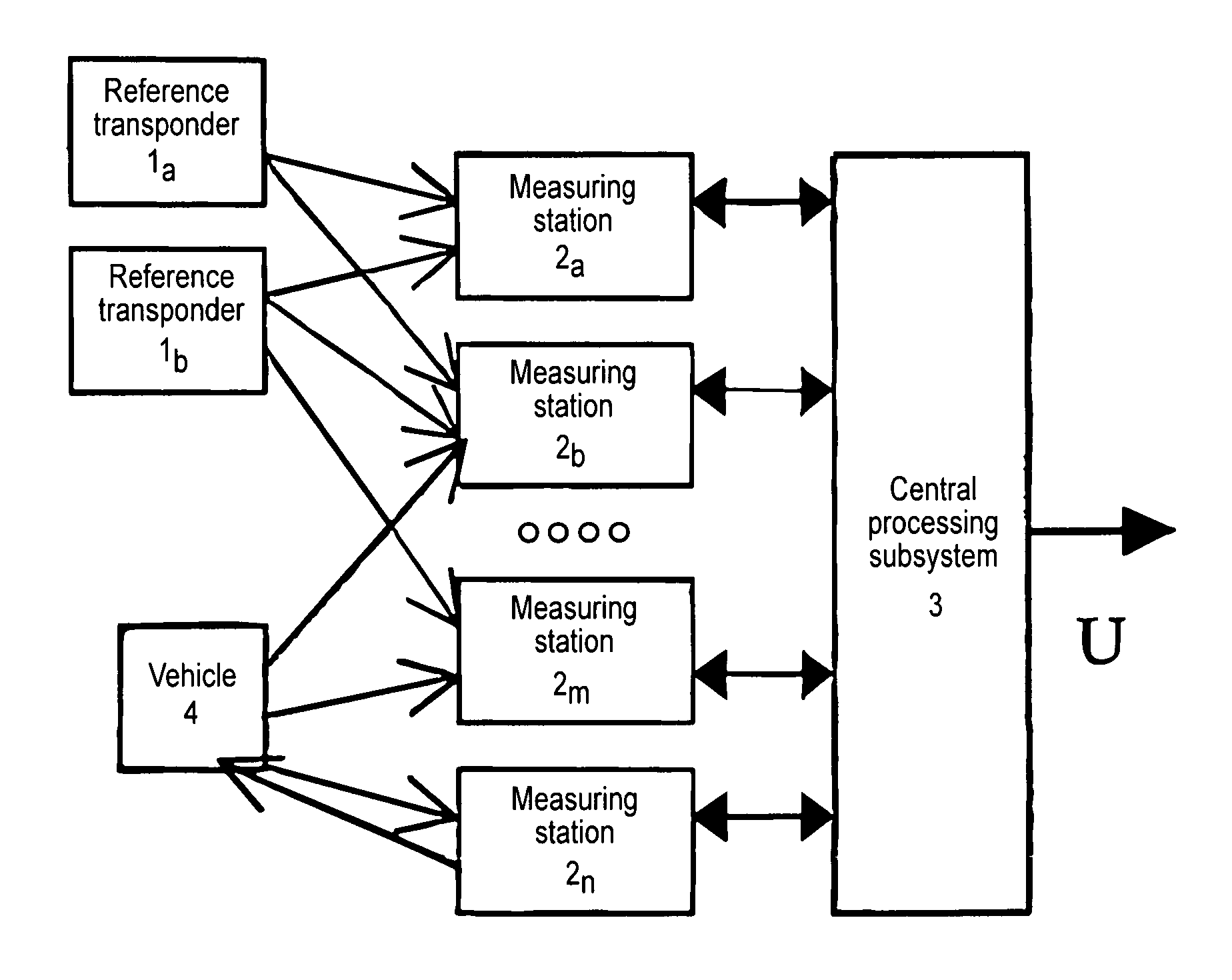
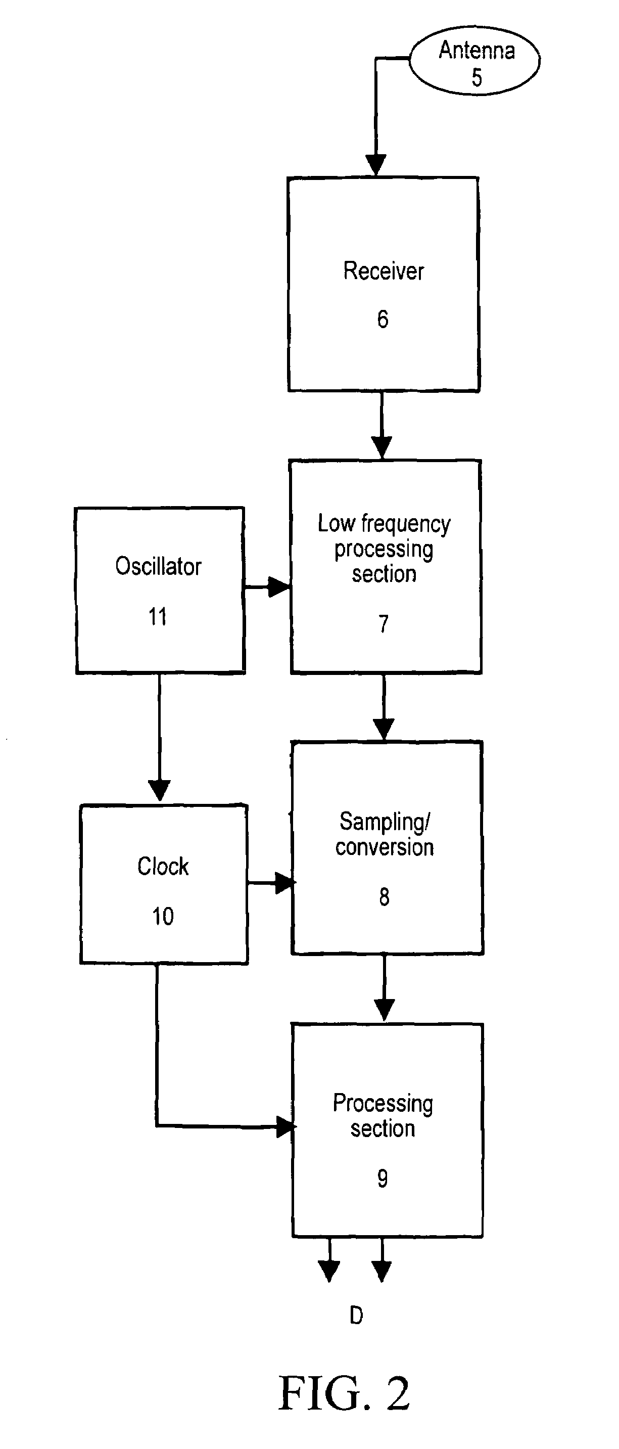
[0041]This invention describes a System composed by various elements—as shown in FIG. 1—operating with reference to the techniques and principles above described:[0042]One or more reference Transponders able to emit standard SSR signals, according to a technique well-known in the field of air traffic control and airport surveillance, (see References [1] and [2]). These reference transponders are indicated with 1a and 1b and their typical number is two both for redundancy reasons, and for the necessity of having in optical visibility all the measuring Stations, that can be as many as fifteen. The reference Transponders are obtainable from the avionic ones in a simple way well-known to the experts.[0043]A certain number (greater than three and of the order about ten or twenty, according to the dimensions of the airport and its configuration) of measuring Stations, indicated with 2a, 2b . . . 2n in FIG. 1. Each Station receives both SSR signals emitted by the standard transponders on b...


PUM


Abstract

A system able to locate and identify aircraft and vehicles based on the reception and processing, with novel means and methods, of signals emitted by the transponder of the secondary surveillance radar, shortly SSR. The system has a number of fixed stations distributed in the area of interest, e.g. in the airport area; any signal (the well known SSR reply / squitter) transmitted by the on-board transponder is received by four or more stations and the measurement of three or more differences of times of arrival (TOA) permits the reconstruction of the position of the transponder in spite of the fact that the transmission time is unknown. Suitable algorithms based on optimal estimation enhance both the accuracy of TOA measurements and the accuracy of the reconstructed position. The effects of possible overlapping of signal in time are avoided or mitigated by multiple source separation techniques based on least squares algebraic processing.

Description

[0001]This application is the US national phase of international application PCT / IB2005 / 051519 filed 10 May 2005 which designated the U.S. and claims priority to IT RM2004A000249 filed 17 May 2004, the entire contents of each of which are hereby incorporated by reference.FIELD OF THE INVENTION[0002]This invention belongs to the field of the management of air traffic and of airport traffic, and of surveillance and identification of mobiles (aircraft, ground vehicles). In particular it is applied in cooperating surveillance using Secondary Surveillance Radar signals transmitted downlink by on-board transponders.BACKGROUND AND SCOPE OF THE INVENTION[0003]This invention is based on the reception and processing, with new means and methods, of signals emitted by an equipment present on board of all aircraft operating in the controlled airspace, i.e. the transponder of the secondary surveillance radar, SSR for short. The invention applies to both transponders with less recent characteristi...

Claims


Application Information

Patent Timeline
Patent Type & Authority Patents(United States)
IPC IPC(8): G01S13/93G01S13/87
CPCG01S7/285G01S13/878G01S13/781G01S2007/4091G01S7/4091
Inventor GALATI, GASPARE
Owner UNIVERSITY OF ROME TOR VERGATA
Why Eureka
Try Eureka