Microwave/infrared remote sensing image combined soil moisture inversion method

A remote sensing image and soil moisture technology, which is applied in the field of remote sensing image processing, can solve problems such as cloud influence, application limitations, and inability to monitor soil moisture, and achieve the effects of improving monitoring efficiency, improving inversion accuracy, and facilitating commercial production

Active Publication Date: 2016-12-14
WUHAN UNIV
View PDF7 Cites 30 Cited by
  • Summary
  • Abstract
  • Description
  • Claims
  • Application Information

AI Technical Summary

Problems solved by technology

When the research area is large, although the optical / thermal infrared remote sensing retrieval of surface soil moisture has a high spatial resolution, it is seriously affected by the cloud layer, resulting in spatial discontinuity of the results, and the soil moisture cannot be effectively used. monitoring
Passive microwave remote sensing has a good physical foundation and is not greatly affected by clouds, but the spatial resolution of spaceborne passive microwave sensors is relatively low, and its application is limited

Method used


Image

  • Microwave/infrared remote sensing image combined soil moisture inversion method
  • Microwave/infrared remote sensing image combined soil moisture inversion method
  • Microwave/infrared remote sensing image combined soil moisture inversion method

Examples


Embodiment Construction

[0048] Specific embodiments of the present invention are described in detail below. It should be noted that the embodiments described here are for illustration only, and are not intended to limit the present invention:

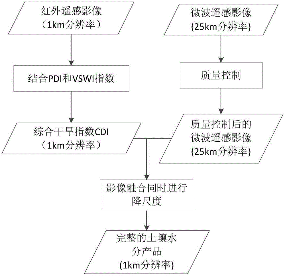
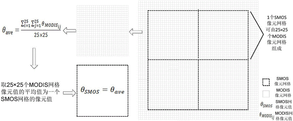
[0049] 1. Calculate the comprehensive drought index of infrared remote sensing images. This example uses MODIS images with a resolution of 1km.

[0050] Compute the vertical drought index of the imagery, In the formula, R redis the atmospherically corrected reflectance in the red band; R nir is the atmospherically corrected reflectance in the near-infrared band; M is the slope of the soil line;

[0051] Calculate the vegetation water supply index of the image, VSWI=NDVI / T s , where T s is the canopy temperature of the vegetation, and NDVI is the normalized difference vegetation index.

[0052] PDI is suitable for areas with low vegetation coverage, and VSWI is suitable for areas with high vegetation coverage. With NDVI as the threshold, the above two in...


PUM


Abstract

The invention relates to a microwave / infrared remote sensing image combined soil moisture inversion method. By combining the applicability characteristics of PDI (precipitation distance index) and VSWI (vegetation supply water index), a remote sensing monitoring model based on CDI (composite drought index) is established according to different ground surface vegetation coverages. The method comprises the following steps: obtaining the CDI result by using infrared remote sensing data, calculating the correlation coefficient between the CDI inversion result and microwave remote sensing data by combining the microwave remote sensing data, establishing a regression equation, carrying out image fusion while downscaling the microwave data, converting the CDI result reversed from the infrared data into true soil moisture value, and filling the infrared data null region with the microwave remote sensing data, thereby obtaining the complete high-resolution soil moisture product. The method is simple and practical, and enhances the wide-range soil moisture inversion efficiency.

Description

technical field [0001] The invention belongs to the field of remote sensing image processing, in particular to a soil moisture inversion method combined with microwave and infrared remote sensing image fusion. Background technique [0002] Surface soil moisture content is not only an important indicator for drought monitoring, but also an important parameter in the fields of climate, hydrology, ecology, agriculture, etc., and is also an important part of global climate change. The development of remote sensing technology provides an effective means for obtaining information on large-scale surface soil moisture. [0003] Optical / thermal infrared remote sensing is mainly based on the spectral reflection characteristics and surface emission characteristics of soil and vegetation on the soil to estimate soil moisture. When the research area is large, although the optical / thermal infrared remote sensing retrieval of surface soil moisture has a high spatial resolution, it is seri...

Claims


Application Information

Patent Timeline
Patent Type & Authority Applications(China)
IPC IPC(8): G01N21/35G01N22/04
CPCG01N21/35G01N22/04
Inventor 张文任燕谢文君胡一杰孟令奎余长慧马晓琳
Owner WUHAN UNIV
Why Eureka
Try Eureka