Ship multi-dimensional navigation system based on ocean numerical prediction model

A numerical prediction and navigation system technology, applied in the field of ship multi-dimensional navigation systems, can solve the problem that two-dimensional electronic charts cannot provide real-time water level information of seabed micro-topography, etc., and achieve the effect of reducing burden and improving calculation accuracy.

Inactive Publication Date: 2017-06-13
TIANJIN UNIV
View PDF10 Cites 2 Cited by
  • Summary
  • Abstract
  • Description
  • Claims
  • Application Information

AI Technical Summary

Problems solved by technology

[0003] The purpose of the present invention is to overcome the deficiencies in the prior art and to provide a ship multi-dimensional navigation system based on the marine numerical forecast model, which solves the problem that the two-dimensional electronic chart cannot provide seabed micro-topography and quickly obtain high-precision real-time A series of questions about water level information

Method used


Image

  • Ship multi-dimensional navigation system based on ocean numerical prediction model
  • Ship multi-dimensional navigation system based on ocean numerical prediction model

Examples


Embodiment Construction

[0020] The present invention will be further described below in conjunction with the accompanying drawings.

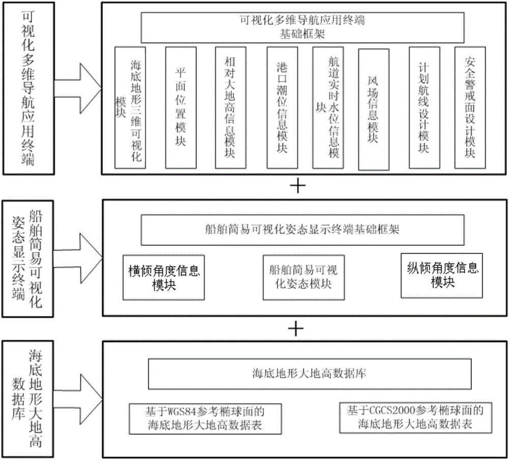
[0021] Such as figure 1 As shown, the present invention protects a ship multi-dimensional navigation system based on a marine numerical prediction model, and aims to provide ships with seabed micro-topography and high-precision real-time water level information on the route in nearshore waters, so as to improve the safety of ship navigation. The system consists of three parts: the seabed topography geodetic database, the visualized multi-dimensional navigation application terminal and the simple visual attitude display terminal of the ship, among which: the seabed topography geodetic database is mainly used to store the seabed topography geodetic data table with WGS84 or CGCS2000 reference ellipsoid , among them, WGS84 is widely used in the world, and CGCS2000 is widely used in my country. The corresponding seabed topographic geodetic data are stored in different tables...


PUM


Abstract

The invention discloses a ship multi-dimensional navigation system based on an ocean numerical prediction model. The ship multi-dimensional navigation system based on the ocean numerical prediction model consists of a submarine topography geodetic height database, a visual multi-dimensional navigation application terminal and a ship simple visual posture display terminal, wherein the submarine topography geodetic height database is used for storing space submarine topography geodetic height data with a position label; the visual multi-dimensional navigation application terminal comprises a submarine topography three-dimensional visual model, a relative geodetic height information module, a plane position module, a port tide level information module, a shipping channel real-time water level information module, a wind field information module, a planned route design module and a security alert face design module; and the ship simple visual posture display terminal is used for displaying posture change, transverse inclination angle information and longitudinal inclination angle information of the ship, so that a ship driver can know the real-time condition of the ship. The system solves a series of problems that a two-dimensional sea chart cannot provide seabed tiny-terrain and cannot acquire high-precision real-time water level information.

Description

technical field [0001] The invention relates to the field of ship navigation, in particular to a ship multi-dimensional navigation system based on a marine numerical prediction model. Background technique [0002] The navigation system provides safety guarantee for the navigation of the ship. With the development of technology, the meaning of navigation is constantly expanding. At present, navigation is no longer limited to simple two-dimensional plane navigation. For ships navigating in near-shore shallow water areas, the micro-topography of the seabed and real-time water level are more important for the safety of ship navigation. However, the two-dimensional electronic charts currently commonly used on ships cannot reflect the micro-topography of the seabed. In addition, the water level information needs to be calculated manually. In areas with limited water depth, low-precision water level estimation will cause losses to water level utilization. Contents of the inventi...

Claims


Application Information

Patent Timeline
Patent Type & Authority Applications(China)
IPC IPC(8): G01C21/20G01W1/10
CPCG01C21/203G01W1/10Y02A10/40
Inventor 张安民张永兵杜佳芸欧阳知雨宁一伟刘禹王宗宪
Owner TIANJIN UNIV
Why Eureka
Try Eureka