Remote sensing detection method based on unmanned aerial vehicle platform

A detection method and unmanned aerial vehicle technology, applied in the field of remote sensing and surveying and mapping, can solve the problems of multi-source heterogeneity that cannot be effectively integrated

Active Publication Date: 2020-09-08
HARBIN INST OF TECH
View PDF13 Cites 5 Cited by
  • Summary
  • Abstract
  • Description
  • Claims
  • Application Information

AI Technical Summary

Problems solved by technology

[0007] Aiming at the problem that existing spectral image data and lidar point cloud data cannot be effectively fused due to multi-source heterogeneity, the present invention provides a remote sensing detection method based on an unmanned aerial vehicle platform

Method used


Image

  • Remote sensing detection method based on unmanned aerial vehicle platform
  • Remote sensing detection method based on unmanned aerial vehicle platform
  • Remote sensing detection method based on unmanned aerial vehicle platform

Examples


specific Embodiment approach 1

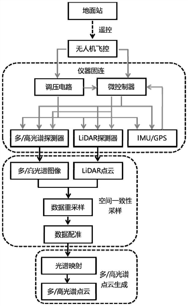
[0084] Specific implementation mode 1. Combination figure 1 As shown, the present invention provides a remote sensing detection method based on an unmanned aerial vehicle platform, realized based on a spectral detector and a LiDAR detector, and the spectral detector is a multi / hyperspectral detector; comprising:

[0085] Step 1: Mount the spectrum detector and LiDAR detector as a whole frame under the UAV, and provide the working voltage through the voltage output interface reserved by the UAV flight controller;

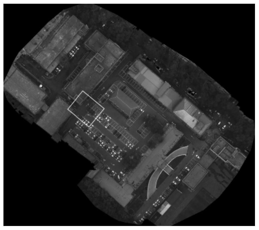
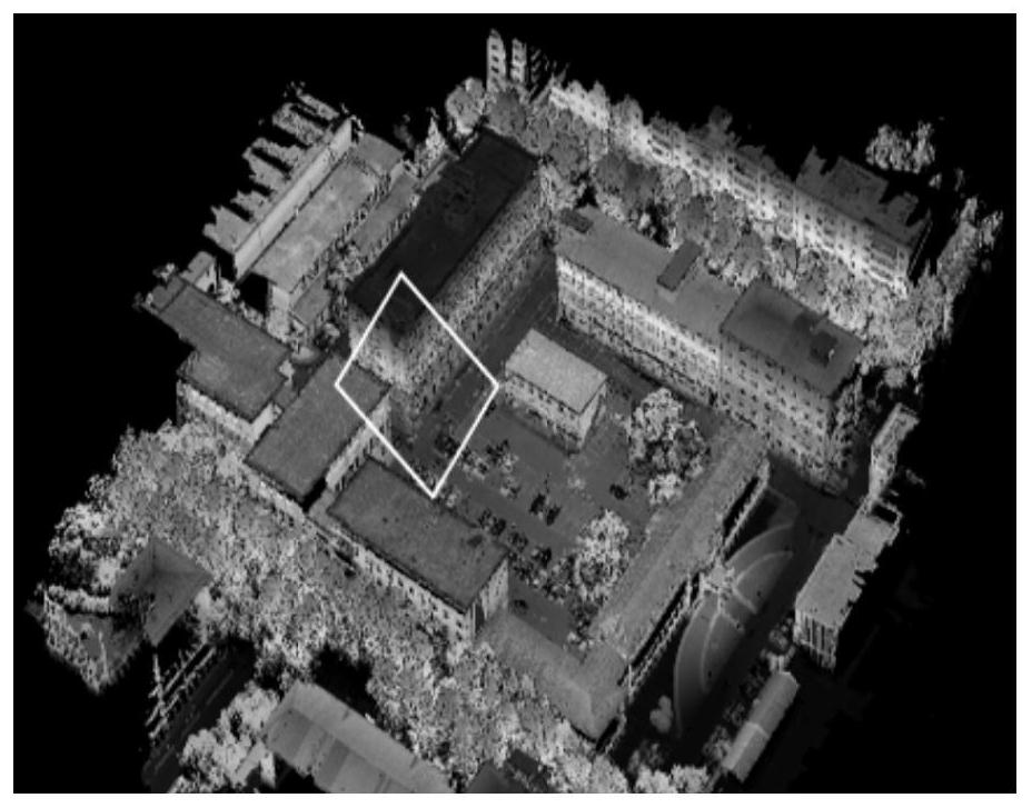
[0086] Step 2: Use the UAV ground station to control the UAV flight controller to send data acquisition commands to the microcontroller, and the microcontroller performs synchronous acquisition and control of the spectrum detector, LiDAR detector and IMU / GPS integrated navigation unit; and The collected spectral image data and LiDAR point cloud data are registered for data registration to obtain the spatial correspondence between the two data; at the same time, the s...


PUM


Abstract

A remote sensing detection method based on an unmanned aerial vehicle platform belongs to the field of remote sensing and surveying. The invention aims to solve the problem that existing spectral image data and laser radar point cloud data cannot be effectively fused due to multi-source heterogeneity. The method comprises the steps of using a spectrum detector and a LiDAR detector as an integral frame to be mounted below an unmanned aerial vehicle; adopting an unmanned aerial vehicle ground station to control an unmanned aerial vehicle flight controller to send a data acquisition command to amicrocontroller, and then performing synchronous acquisition control on a spectrum detector, a LiDAR detector and an IMU/GPS integrated navigation unit; performing data registration to obtain a spatial corresponding relationship between the two types of data; performing up-sampling on the acquired data to realize spatial consistency sampling of the data; fusing the spectral image data and the LiDAR point cloud data according to the spatial corresponding relation to obtain multi-spectral/hyperspectral point cloud data. According to the invention, on the basis of realizing integrated detection of image-spectrum-space multi-dimensional data, spectrum and space information is fused, and finally spectrum point cloud is generated.

Description

technical field [0001] The invention relates to a remote sensing detection method based on an unmanned aerial vehicle platform, and belongs to the field of remote sensing and surveying and mapping. Background technique [0002] Remote sensing (Remote Sensing) is defined as a means of acquiring and measuring environmental (target, material, phenomenon) attribute information without direct contact. In terms of space technology, remote sensing usually refers to a method of recording the electromagnetic energy emitted or reflected by the earth's land surface, oceans, regions or objects in the atmosphere; The data collected by remote sensing can realize the distinction of different types of objects. Remote sensing data are generally collected by remote sensing instruments installed on aircraft or Earth-orbiting spacecraft, which gives scientists the opportunity to observe and analyze geographical areas of larger scenes; therefore, in fire monitoring, glacier monitoring, coastal ...

Claims


Application Information

Patent Timeline
Patent Type & Authority Applications(China)
IPC IPC(8): G01N21/25G01S17/89
CPCG01N21/25G01S17/89
Inventor 谷延锋向润梓杨圣雄
Owner HARBIN INST OF TECH
Why Eureka
Try Eureka