
Vehicle target motion speed detection method based on UAV multi-source images
A technology of motion speed and detection method, applied in image analysis, image enhancement, image data processing and other directions, can solve the problems of error, fixed monitoring location, high cost of laser and radar detection technology, and achieve the effect of easy operation
- Summary
- Abstract
- Description
- Claims
- Application Information
AI Technical Summary
Problems solved by technology
Method used
Image

Examples
Embodiment
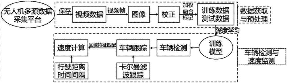
[0036] Embodiment: a kind of vehicle target motion speed detection method based on unmanned aerial vehicle multi-source image, it is characterized in that: comprise the following steps:
[0037] Step 1. Build a UAV multi-source image acquisition platform;
[0038] Step 2: Use the image acquisition platform to collect image data, obtain the multi-source images of the visible light camera and thermal infrared camera through the computer motherboard of the UAV platform, and transmit the multi-source image data to the ground monitoring client through 4G to complete the real-time monitoring of the images Obtain;
[0039] Step 3, correcting the acquired image data to reduce the geometric distortion of the image data;
[0040] Step 4, registering the corrected multi-source image data;
[0041] Step 5, performing weighted fusion on the registered multivariate image data;
[0042] Step 6. Based on the weighted and fused multi-source image data, the vehicle target is detected;
[00...
PUM
 Abstract
Description
Claims
Application Information