Ecological spatial data fusion method

A technology of spatial data and fusion method, applied in the field of geographic information, can solve problems affecting the speed and efficiency of data analysis, high cost of obtaining spatial data, frequent changes of database data, etc., to improve storage and access efficiency and good update ability , the effect of saving resources

Inactive Publication Date: 2019-10-15
重庆财经学院
View PDF2 Cites 2 Cited by
  • Summary
  • Abstract
  • Description
  • Claims
  • Application Information

AI Technical Summary

Problems solved by technology

[0003] At present, the traditional data update methods are continuous snapshot method and base state correction method. The continuous snapshot method causes database data to change very frequently and generates a large amount of redundant data. The base state correction method sets the state at a certain moment as the base state, and the storage is relatively The amount of change in the base state, although it solves the problem of data redundancy, increases the workload of the query
[0004] Traditional data analysis and fusion methods, due to different data collection methods or organizational systems, lead to heterogeneous spatial data and cannot be directly reused. The cost of data is high and the time is long. Single use of the ArcGis platform to analyze data requires a large workload of data analysis. When processing data in batches, many invalid and useless data occupy data storage space, which seriously affects the speed and efficiency of data analysis.

Method used


Image

  • Ecological spatial data fusion method
  • Ecological spatial data fusion method
  • Ecological spatial data fusion method

Examples


Embodiment 1

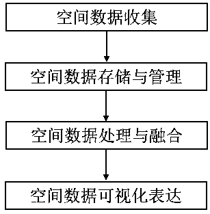
[0044]figure 1 A schematic flow chart of the spatial data fusion method provided in this embodiment, such as figure 1 Shown:

[0045] A fusion method of ecological space data, the method comprising the following steps:

[0046] 1. Spatial data collection, collecting different types of data from different data sources in real time or in a timely manner and sending them to the storage system;

[0047] 2. Spatial data storage and management, according to application requirements and data characteristics, select storage methods and organizational management forms;

[0048] 3. Spatial data processing and fusion. According to the requirements of statistical analysis of natural resources, use geospatial big data analysis technology to realize high-performance data parallel computing and statistical analysis, and complete the processing and fusion of spatial data;

[0049] 4. Visual expression of spatial data, use the data information of geospatial big data, select the corresponding...

Embodiment 2

[0056] A fusion method of ecological space data, wherein in the third step, the vector data is preprocessed through FME module design, and the specific steps are as follows:

[0057] For example, A and B represent the element data of the adjacent faces at the edge.

[0058] 1.1. The algorithm for checking the geometric edges of polygon elements is as follows:

[0059] (1) Transform A and B into line elements A1 and B1 respectively, and perform intersecting interrupt processing on them respectively, and record the results as A2 and B2 respectively;

[0060] (2) Perform fusion processing on A2 and B2 respectively, and record the results as A3 and B3 respectively;

[0061] (3) Extract the start and end nodes of A3 and B3 respectively, and perform de-duplication processing, and then perform intersection processing with the border boundary, and the intersection nodes are respectively recorded as A4 and B4;

[0062] (4) Carry out capping processing on A4 and B4, if the overlapping...

Embodiment 3

[0081] A fusion method of ecological space data, wherein in the step 3, the fusion of spatial data includes 3 parts: data structure unification, vector data fusion, data consistency processing, the specific steps are as follows:

[0082] Unified data structure: Based on the basic database, effectively combine the time dimension and space dimension of spatial data to construct spatio-temporal data grid units, assign corresponding attributes to spatial data through spatio-temporal grid units, and form a unified spatial data structure ;

[0083] Vector data fusion: All the elements in the spatial database are fused geometrically and semantically, and the same-name entity recognition technology based on spatial acquaintance is used to match the elements with the same name in the data overlapping area. By comparing the timeliness, accuracy and integrity of the elements with the same name properties, etc., determine the choice of elements with the same name, and retain the only elem...


PUM


Abstract

The invention discloses an ecological spatial data fusion method, which belongs to the technical field of geographic information. The ecological spatial data fusion method comprises the following steps: 1, spatial data collection: collecting different types of data from different data sources in real time or in time; 2, spatial data storage and management: selecting a storage mode and an organization and management mode according to application requirements and data characteristics; 3, spatial data processing and fusion: realizing high-performance data parallel computing and statistical analysis work by utilizing a geographic space big data analysis technology according to a natural resource statistical analysis requirement, and finishing processing and fusion of spatial data; and 4, spatial data visual expression: selecting a corresponding visual expression scheme by utilizing data information of geographic space big data, and converting a natural resource investigation monitoring result into information required by a user. According to the ecological spatial data fusion method, a computer software processing technology is adopted in the aspect of data processing, and the data processing speed and efficiency are improved.

Description

technical field [0001] The invention belongs to the technical field of geographic information, and in particular relates to a fusion method of ecological space data. Background technique [0002] The advent of the era of big data not only makes people realize the importance of data, but also triggers fundamental changes in many fields. The development of technologies such as web2.0 and the emergence of new concepts of geographic information production, dissemination and sharing, such as spontaneous geographic information and public participation in geographic information, have comprehensively promoted the development of earth system science in data collection, acquisition, distribution and sharing, making The stock of geospatial data is increasing day by day and showing an explosive trend, and earth system science has entered the era of big data; geospatial data is data related to the spatial position of the earth reference, expressing the attributes of various entities and ...

Claims


Application Information

Patent Timeline
Patent Type & Authority Applications(China)
IPC IPC(8): G06F16/29
CPCG06F16/29
Inventor 周启刚曾波孟伟
Owner 重庆财经学院
Why Eureka
Try Eureka