Remote sensing image segmentation method based on multitask semi-convolution

A remote sensing image, multi-task technology, applied in image analysis, image enhancement, image data processing and other directions, can solve the problems of blurred boundaries, classification errors, and high complexity of remote sensing image backgrounds, to improve accuracy, reduce detail errors, improve The effect of the ability to portray

Pending Publication Date: 2020-04-14
TIANJIN UNIV
View PDF6 Cites 1 Cited by
  • Summary
  • Abstract
  • Description
  • Claims
  • Application Information

AI Technical Summary

Problems solved by technology

[0004] Due to the high complexity of the remote sensing image background, the semantic segmentation method directly applied to the remote sensing image can

Method used


Image

  • Remote sensing image segmentation method based on multitask semi-convolution
  • Remote sensing image segmentation method based on multitask semi-convolution
  • Remote sensing image segmentation method based on multitask semi-convolution

Examples


Embodiment Construction

[0036] The present invention will be described in further detail below in conjunction with the accompanying drawings and specific embodiments. It should be understood that the specific embodiments described here are only used to explain the present invention, not to limit the present invention.

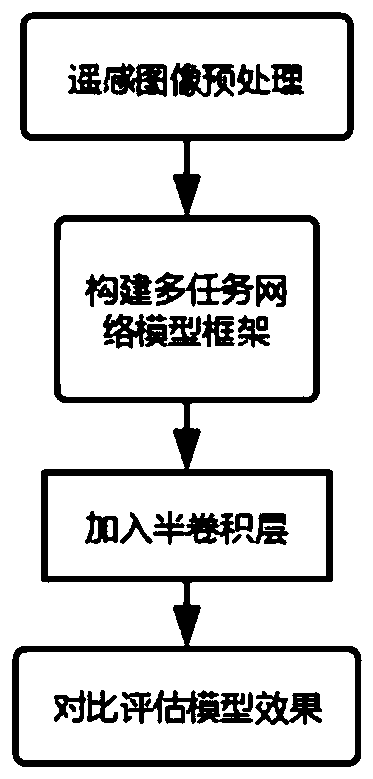
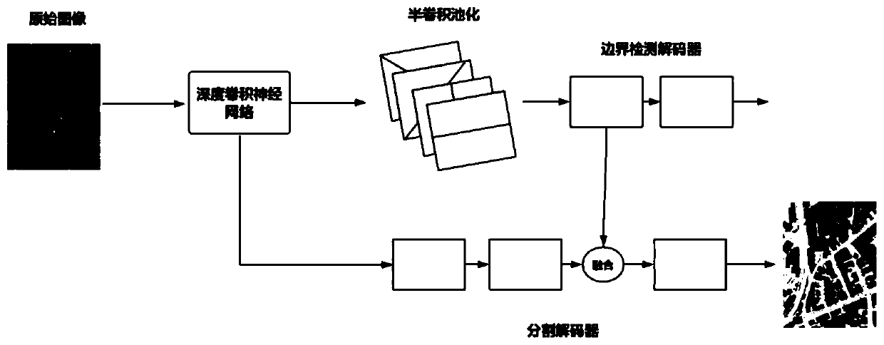
[0037] The invention provides a remote sensing image segmentation method based on multi-task semi-convolution, such as figure 1 Shown is a schematic flow chart of a specific embodiment of the present invention, as figure 2 Shown, is concrete multi-task semi-convolutional neural network structural diagram among the present invention, and the present invention comprises:

[0038] Step 1: Preprocessing the remote sensing image to remove the interference factors in the image, such as color imbalance; the details are as follows:

[0039] Step 101: the present invention adopts the method of Reinhard color transfer, to the overall remote sensing image data set I O Unify the colors. Orga...


PUM


Abstract

The invention discloses a remote sensing image segmentation method based on multi-task semi-convolution. The method comprises the following steps: step 1, carrying out the preprocessing of an originalremote sensing image IO, and obtaining a remote sensing image I1 after the interference factors in the image are removed; step 2, constructing a multi-task segmentation network, performing boundary prediction and segmentation prediction tasks on the remote sensing image and adjusting the structure of the multi-task segmentation network to adapt to a specific application scene; and step 3, addingthe semi-convolution into the multi-task segmentation network so as to further improve the effect of the multi-task segmentation network. According to the method, the purpose of boundary refinement isachieved through targeted extraction of boundary information by multi-task reuse features and semi-convolution. Benefited from the boundary refinement of the method, the remote sensing image segmentation method provided by the invention remarkably improves the overall segmentation accuracy, improves the segmentation accuracy by 0.9% in comparison with the existing optimal method in a public dataset test and reduces 7.9% of detail errors in the optimal method.

Description

technical field [0001] The invention belongs to the fields of deep learning, computer-aided design and remote sensing image processing, relates to using a deep neural network to understand image semantics, classifying and segmenting images, and proposes a multi-task-based semi-convolution remote sensing image semantic segmentation method. Background technique [0002] Satellites such as NOAA, MODIS, Landsat TM, etc. for Earth observation produce an increasing number of images of different types, resolutions, spectral resolutions and temporal resolutions. These remote sensing images are widely used in land surveying and mapping, agricultural research, environmental research, urban area division and other fields, and also have many applications in the analysis and processing of the relationship between natural resources and human activities. Therefore, it is necessary to segment each remote sensing image. Remote sensing image segmentation is the process of processing remote s...

Claims


Application Information

Patent Timeline
IPC IPC(8): G06T7/13G06T7/12G06N3/04
CPCG06T7/13G06T7/12G06T2207/10004G06T2207/20081G06N3/045
Inventor 于瑞国傅旭洲喻梅李雪威王臣汉姜汉刘志强高洁
Owner TIANJIN UNIV
Why Eureka
Try Eureka