Mountain city land utilization evolution simulation method

A simulation method and land technology, applied in the field of geographic information, can solve problems such as the influence of terrain, road network and other construction land layout, large slope, etc., to achieve the effect of improving simulation accuracy

Pending Publication Date: 2022-04-29
HOHAI UNIV
View PDF1 Cites 2 Cited by
  • Summary
  • Abstract
  • Description
  • Claims
  • Application Information

AI Technical Summary

Problems solved by technology

[0004] The present invention provides a method for simulating the evolution of land use in mountainous cities, which can effectively solve the problem that in the current simulation of urban land use evolution proposed in the above background technology, there are few simulations for special cities such as mountains. With large drop and steep slope, the distribution of various land use types will be obviously affected by the terrain, and due to terrain and mountain barriers, the layout of construction land such as interconnected road networks between towns and groups is also deeply affected.

Method used


Image

  • Mountain city land utilization evolution simulation method
  • Mountain city land utilization evolution simulation method
  • Mountain city land utilization evolution simulation method

Examples


Embodiment 1

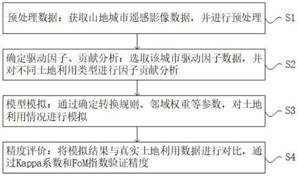
[0047] Such as Figure 1-2 As shown, the present invention provides a kind of technical scheme, a kind of simulation method of mountain city land use evolution, comprises following concrete steps:

[0048] S1. Preprocessing data: Obtain remote sensing image data of mountainous cities and perform preprocessing;

[0049] S2. Determine the driving factors and contribute to analysis: select different types of plots and driving factors in the city, and conduct contribution analysis;

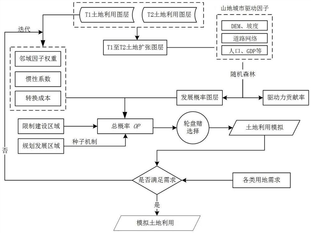
[0050] S3. Model simulation: input parameters in the model, adjust parameters to simulate land use;

[0051] S4. Accuracy evaluation: compare the simulation results with real land use data, and calculate the simulation accuracy through Kappa coefficient and FoM index.

[0052] According to the above technical scheme, in S2, the contribution of each factor to the change of different land use types is analyzed, and the root mean square error and the out-of-bag root mean square error detection value un...

Embodiment 2

[0076] Taking Liangjiang New District of Chongqing as an example, the implementation steps are as follows:

[0077] Step 1: Preprocess the data

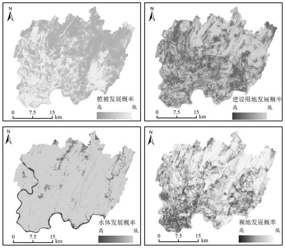
[0078] Obtain two phases of remote sensing images of Liangjiang New Area on the Google Earth Engine platform, combined with Google Earth high-definition images, classify the images through visual interpretation, and obtain the land use data of the start year and end year. The classification system is combined with the specific conditions of the local mountainous cities. : Construction land (mainly including urban industrial and mining land, urban residential land, traffic water use land), vegetation (mainly including trees, shrubs and various forest vegetation), bare land (mainly including unused land) and water body (mainly including rivers, lakes and reservoirs) ).

[0079] The basic driving factor data was obtained from the OpenStreetMap platform, the Resource and Environmental Science and Data Center of the Chinese Academy of Sc...


PUM


Abstract

The invention discloses a simulation method for mountain city land utilization evolution, which comprises the following specific steps: S1, data preprocessing: acquiring mountain city remote sensing image data, and preprocessing, S2, driving factor determination and contribution analysis: selecting city driving factor data, and performing factor contribution analysis on different land utilization types, s3, model simulation: simulating the land utilization condition by determining parameters such as a conversion rule and a neighborhood weight, and S4, precision evaluation: comparing a simulation result with real land utilization data, and verifying the precision through a Kappa coefficient and a FoM index. Simulation is carried out on the basis of an improved CA model-PLUS model, a new conversion rule data mining framework in the model can be used for identifying a rule of land utilization change, the advantages of a conversion analysis strategy and a pattern analysis strategy are combined, and the conversion analysis strategy and the pattern analysis strategy are combined by increasing special driving factors of a mountain city and distinguishing the contribution degree of each factor, so that the accuracy of the conversion analysis strategy is improved. The land utilization simulation precision of the mountainous city is improved, so that the driving factors of land utilization evolution of the mountainous city are accurately analyzed, and the land utilization change is accurately simulated.

Description

technical field [0001] The invention relates to the technical field of geographic information, in particular to a method for simulating the evolution of land use in mountainous cities. Background technique [0002] At present, most of the existing land use simulation models use the cellular automata model and a series of improved models derived from it. In order to improve the simulation accuracy and calculation speed, the improved cellular automata model technology is gradually developed. For example, in the application In the Chinese patent No. 201410409993.8 "A Random Forest-Based Cellular Automata City Expansion Simulation Method", a random forest-cellular automata model is proposed; [0003] However, in the current simulation of urban land use evolution, there are few simulations for special cities such as mountains. Due to the high terrain, large drop, and large slope of mountainous cities, the distribution of various land use types will be obviously affected by the te...

Claims


Application Information

Patent Timeline
Patent Type & Authority Applications(China)
IPC IPC(8): G06F30/27G06V20/13G06K9/62G06F111/04G06F111/08
CPCG06F30/27G06F2111/08G06F2111/04G06F18/24323G06F18/2415
Inventor 张晓祥杨妍菲薛明慧钟语箐
Owner HOHAI UNIV
Why Eureka
Try Eureka