GPS position-finding system and method of finding position of GPS terminal

Inactive Publication Date: 2005-06-02
NEC CORP
View PDF5 Cites 26 Cited by
  • Summary
  • Abstract
  • Description
  • Claims
  • Application Information

AI Technical Summary

Benefits of technology

[0014] In view of the above-mentioned problems in the conventional GPS systems, it is an object of the present invention to provide a p

Problems solved by technology

When a small terminal such as a mobile phone is used for finding a position thereof through the use of GPS, it is often impossible to capture a satellite, for instance, if the terminal is surrounded by buildings or the terminal is used indoors.
A terminal having conventional GPS cannot receive altitude data.
Thus, if an actual altitude of the terminal is highly different

Method used


Image

  • GPS position-finding system and method of finding position of GPS terminal
  • GPS position-finding system and method of finding position of GPS terminal
  • GPS position-finding system and method of finding position of GPS terminal

Examples


Example

First Embodiment

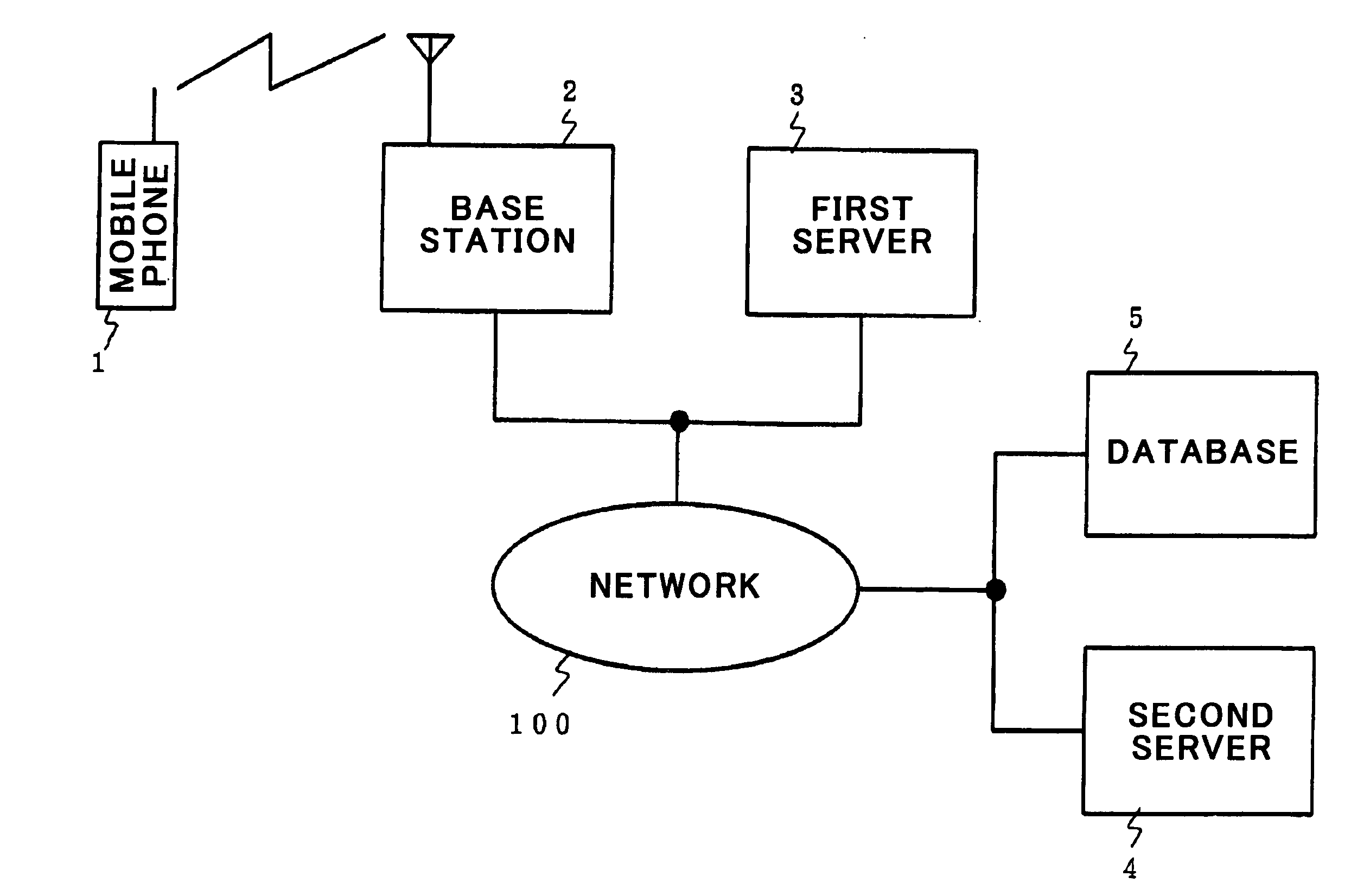
[0076]FIG. 1 is a block diagram of a position-finding system in accordance with the first embodiment of the present invention.

[0077] The position-finding system in accordance with the first embodiment is comprised of a mobile phone 1, a base station 2, a first server 3 for providing data relating to mobile phones, a second server 4 for providing assistant data necessary for finding a position through a global positioning system (GPS), and a database storing terrain data therein.

[0078] The base station 2, the first server 3, the second server 4, and the database 5 are designed to be able to make communication with one another through a network 100 such as a public network or Internet.

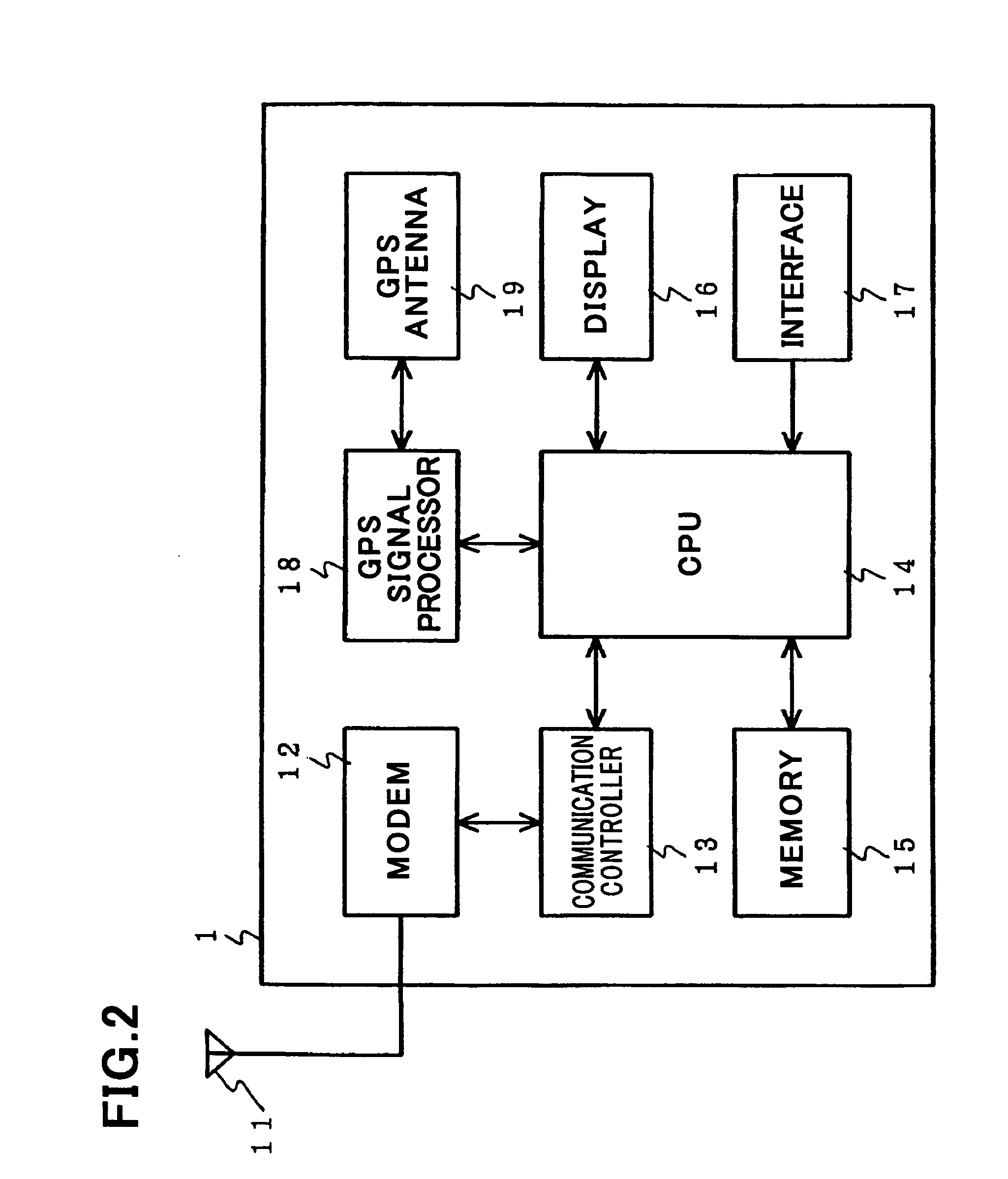
[0079] The mobile phone 1 is designed to have a global positioning system (GPS), and makes communication with the base station 2 through a radio-signal network. The mobile phone 1 makes communication with the second server 4 through the network 100 to receive assistant data from the s...

Example

Second Embodiment

[0120]FIG. 7 is a flow-chart showing steps to be carried out by the central processing unit 14 in the mobile phone 1 in accordance with the second embodiment, and FIG. 8 is a flow-chart showing steps to be carried out by the GPS signal processor 18.

[0121] The system for finding a position of the mobile phone 1 in accordance with the second embodiment is identical with the system in accordance with the first embodiment.

[0122] In the above-mentioned first embodiment, accuracy of an estimated altitude is calculated in the second server 4. In the second embodiment, the GPS signal processor 18 judges whether two-dimensional position-finding is carried out such that accuracy of an estimated altitude required by a user or an application is ensured, based on an estimated altitude received from the second server 4.

[0123] On receipt of an instruction from a user, for instance, the central processing unit 14 judges whether three-dimensional position-finding is selected by ...

Example

Third Embodiment

[0149]FIG. 9 illustrates a positional relation between the base station 2 and cells in the third embodiment of the present invention.

[0150] In accordance with the third embodiment, the accuracy ALTqua of an estimated altitude provided from the database 5 is enhanced.

[0151] In the third embodiment, when the mobile phone 1 receives assistant data from the second server 4, the mobile phone 1 transmits data indicative of a base station or base stations which the mobile phone 1 captures, to the second server 4.

[0152] With reference to FIG. 9, in the third embodiment, the mobile phone 1 captures a base station(s) or a cell(s) determined in dependence on a location of the mobile phone 1 in a cell(s). This ensures that an estimated altitude in a smaller area can be calculated.

[0153]FIG. 9 illustrates an example in which the mobile phone 1 registered in a first base station 20A is located in a cell A-1.

[0154] If the mobile phone 1 is located in an area Aa, the mobile ph...


PUM


Abstract

A position-finding system is comprised of a terminal having a global positioning system (GPS) for finding a position thereof, and a server which calculates altitude data, based on terrain data in an area in which the terminal is. The terminal includes a controller which selects one of three-dimensional position-finding in which a position is calculated through the use of four or more satellites and two-dimensional position-finding in which a position is calculated in a circumference in which only three satellites can be captured, in accordance with the altitude data provided from the server.

Description

BACKGROUND OF THE INVENTION [0001] 1. Field of the Invention [0002] The invention relates to a position-finding system for finding a position of a terminal, a server used in the position-finding system, a mobile terminal used in the position-finding system, a GPS receiver used in the position-finding system, a method of finding a position of a terminal in the position-finding system, and a program for causing a computer to carry out the method. [0003] 2. Description of the Related Art [0004] In these years, a global positioning system (GPS) is mounted not only in devices used outdoors such as a car navigation system or a measurement unit, but also in a mobile terminal such as a mobile phone. With popularization of GPS, a device including GPS is required to have higher sensitivity and accuracy. [0005] In a conventional method of finding a position of something through the use of GPS, a position was measured only with GPS. In contrast, there has been suggested a method of finding a po...

Claims


Application Information

Patent Timeline
IPC IPC(8): G01S1/00G01C21/00G01S5/00G01S19/05G01S19/12G01S19/23G01S19/24G01S19/46G08G1/005H04W64/00
CPCG01S19/50G01S19/48
Inventor ODAMURA, SATOSHI
Owner NEC CORP
Why Eureka
Try Eureka