Method for computing code phase pseudo range between locating terminal and satellite in auxiliary global satellite positioning system

A global satellite positioning and positioning terminal technology, applied in the field of global satellite positioning and mobile communication

Inactive Publication Date: 2008-12-03
孟详粤
View PDF0 Cites 18 Cited by
  • Summary
  • Abstract
  • Description
  • Claims
  • Application Information

AI Technical Summary

Problems solved by technology

[0008] The present invention aims at the above problems caused by the terminal obtaining the pseudo-range by itself in the traditional GPS positioning, and proposes a method for calculating the pseudo-range between the A-GPS positioning terminal and the satellite in the Assisted Global Satelli

Method used


Image

  • Method for computing code phase pseudo range between locating terminal and satellite in auxiliary global satellite positioning system
  • Method for computing code phase pseudo range between locating terminal and satellite in auxiliary global satellite positioning system
  • Method for computing code phase pseudo range between locating terminal and satellite in auxiliary global satellite positioning system

Examples


Embodiment Construction

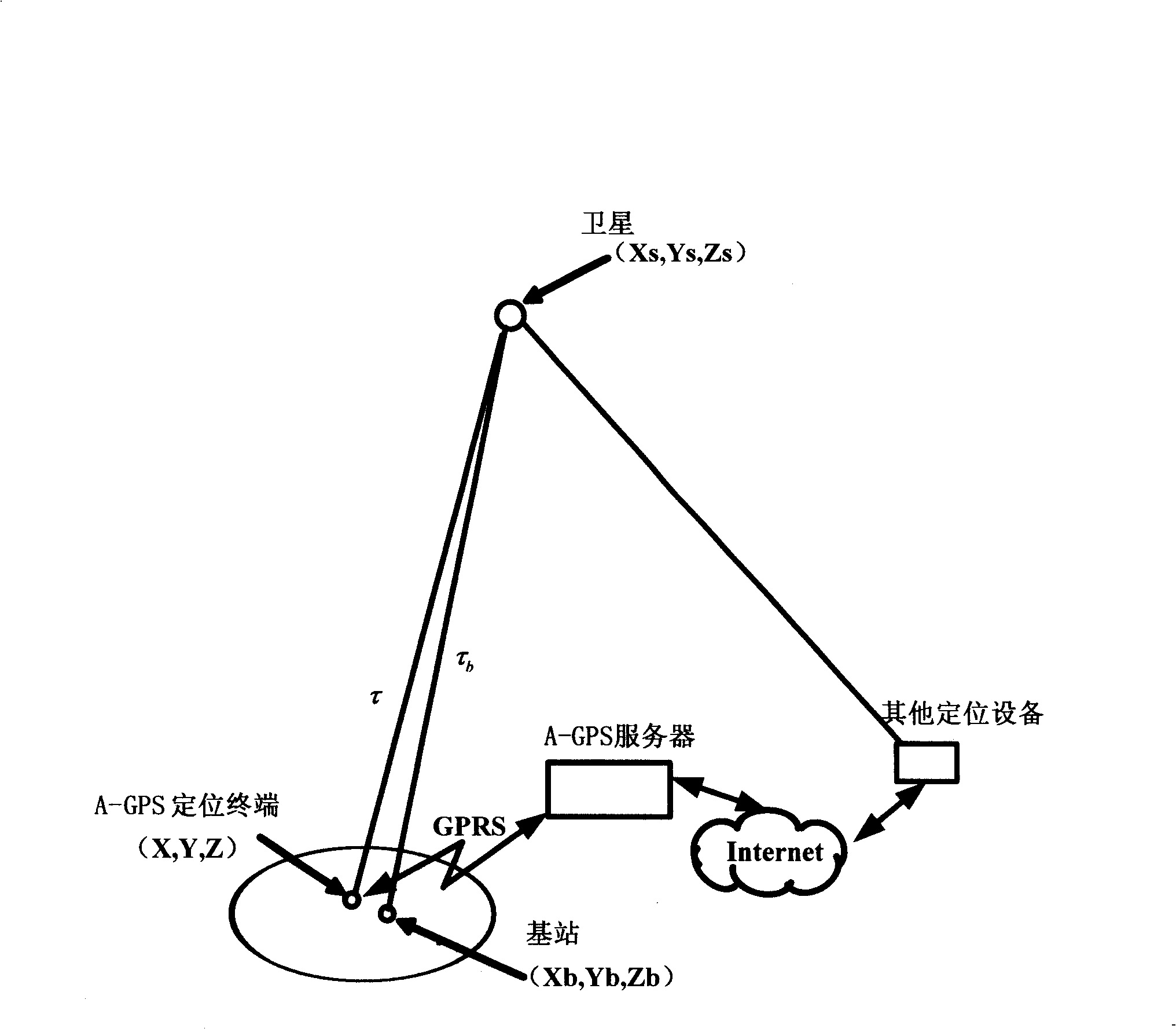
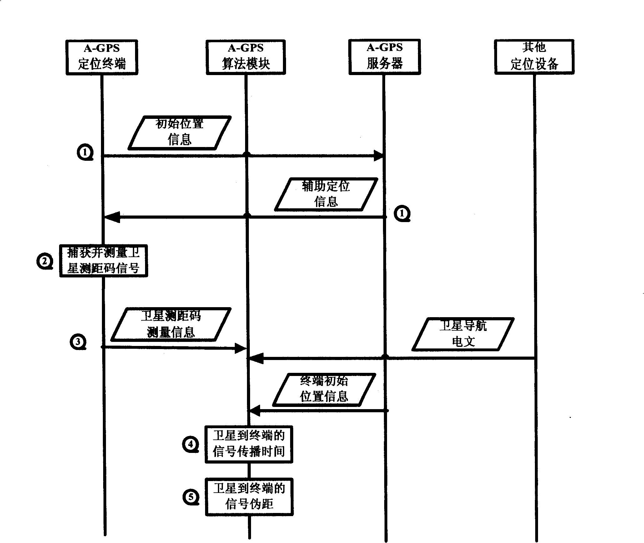
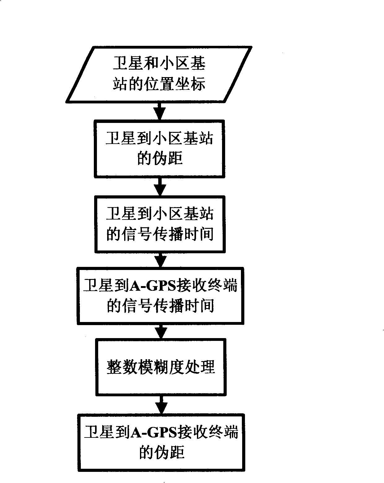
[0022] Since the GPS satellite signal propagates at the speed of light, the pseudo-range P is required, which is essentially the time τ of signal propagation. In the present invention, the initial position of the A-GPS positioning terminal is estimated first, and the pseudo-range from the initial position to the satellite is calculated, thereby obtaining the corresponding signal propagation time; The equivalent time difference of the signal propagation from the actual position of the signal acquisition terminal relative to the initial position, that is, the value of the whole chip and the fragmented chip; the time splicing of the signal propagation time from the base station to the satellite and the chip information of the A-GPS terminal is performed to obtain The signal propagation time from the A-GPS positioning terminal to the satellite; the integer ambiguity processing is performed on this time, and then multiplied by the speed of light to obtain the pseudo-range from the A...


PUM


Abstract

The invention provides a method for calculating the code phase pseudorange between a locating terminal and a satellite in an A-GPS. An A-GPS locating terminal captures the distance measuring signals of satellite and gets the measuring information according to the assistant information received from the network rapidly; an A-GPS algoritic module makes use of the initial position provided by the A-GPS locating terminal and the satellite navigation teletext information provided by the other locating devices to work out the pseudorange from the initial position to the satellite; then the A-GPS algoritic module makes use of the measuring information of terminal to work out the corrected range between the initial position and the actual terminal position; and then the actual pseudorange between the A-GPS locating terminal and the satellite is further worked out. The method inherits the method that the traditional GPS locating system conducts the location through code phase pseudorange; the locating process that the A-GPS locating terminal does not need to download directly, the satellite navigation teletext is obtained indirectly through a network, and the A-GPS locating terminal completes the fast capture of the satellite signals and calculation of the pseudorange information is realized.

Description

technical field [0001] The present invention relates to technical fields such as global satellite positioning and mobile communication, particularly a kind of mobile communication data network (such as GSM / GPRS, WCDMA and CDMA2000) and global satellite positioning system (such as GPS system) are combined, realize the latter in the former The method of positioning with the assistance of Background technique [0002] The traditional GPS (Global Positioning System) single-point positioning mainly uses the pseudo-range measurement method, which is based on the following formula: [0003] ρ 1 = ( x 1 - x u ) ...

Claims


Application Information

Patent Timeline
IPC IPC(8): G01S5/14G01S5/02G01S19/45
Inventor (请求不公开姓名)
Owner 孟详粤
Why Eureka
Try Eureka