A Surveying and Mapping Method for Initial Back-arc Basin Continental Shelf Delineation
What is AI technical title?
AI technical title is built by Patsnap AI team. It summarizes the technical point description of the patent document.
A technology for basins and toe-points of continental slopes, which is used in surveying, mapping and navigation, measuring devices, cross-section depiction, etc.
Active Publication Date: 2014-10-01
SECOND INST OF OCEANOGRAPHY MNR
View PDF5 Cites 0 Cited by
Summary
Abstract
Description
Claims
Application Information
AI Technical Summary
This helps you quickly interpret patents by identifying the three key elements:
Problems solved by technology
Method used
Benefits of technology
Problems solved by technology
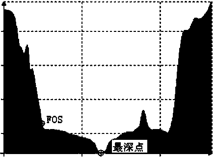
[0006] Aiming at the problem that it is difficult to quantify and determine the outer limit of the continental shelf in trough-shaped back-arc basins caused by the variable geological attributes of the active continental margin and complex seabed topography, the present invention proposes to use the deepest line of the axis as the outer limit of the continental shelf and the central axis as a reference for research and judgment , and gives a detailed identification process
Method used
Image
Click on the blue label to locate the original text in one second.
Reading with bidirectional positioning of images and text.
Examples
Embodiment 1
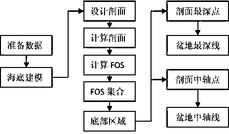
[0050] A method for surveying and mapping initial back-arc basin continental shelf delimitation, comprising the following steps:
[0051] The technical flow chart that the example of the present invention completes sees figure 1 ;
[0052] Step 1: Prepare Data
[0053] 1.1) Organize data: if there is a water depth data set Among them, i and N dp is a natural number, dp i is the depth of water, N dp is the total number of sounding points, turn to step 2;
[0054] 1.2) Surveying and mapping data: If there is no water depth data in step 1.1), use a multi-beam bathymeter to conduct surveying and mapping in full-coverage detection mode and obtain a water depth data set Then go to step 2;
[0055] Step 2: Modeling the Seabed
[0056] Based on dataset Using the inverse distance weighting method to construct a digital model of seabed terrain m d and N d is the maximum row number and maximum column number of the model, j, M d and N d are natural numbers, dep i,j is t...
Embodiment 2
[0079] Taking an actual back-arc basin as an example to further illustrate the implementation process of this patent:
[0080] Step 1: Prepare Data
[0081] 1.1) Organize data: if there is a water depth data set Among them, i and N dp is a natural number, dp i is the depth of water, N dp is the total number of sounding points, turn to step 2;
[0082] 1.2) Surveying and mapping data: If there is no water depth data in step 1.1), use a multi-beam bathymeter to conduct surveying and mapping in full-coverage detection mode and obtain a water depth data set Then go to step 2;
[0083] Step 2: Modeling the Seabed
[0084] Based on dataset Using the inverse distance weighting method to construct a digital model of seabed terrain m d and N d is the maximum row number and maximum column number of the model, j, M d and N d are natural numbers, dep i,j is the water depth point of the model;
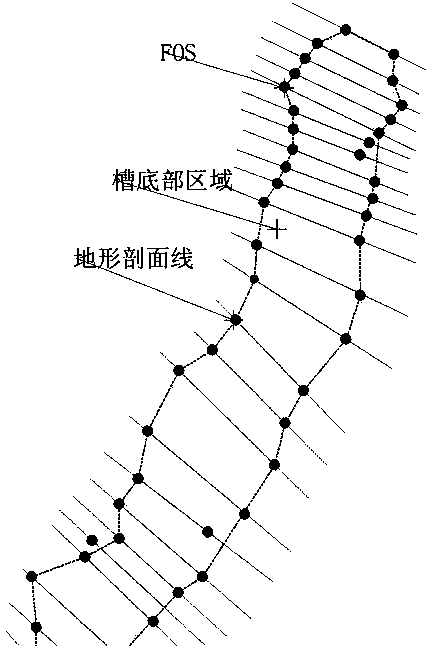
[0085] Step 3: Determine the bottom area
[0086] 3.1) Design section: verti...
PUM
Abstract
The invention discloses a surveying and mapping method for initial back-arc basin continental shelf delimitation. The surveying and mapping method comprises the following steps: (1) surveying and mapping high-precision data of a description region; (2) constructing a seabed multi-dimensional digital model of the description region; (3) constructing a core region of an axial description; (4) identifying the deepest point in an axial region to form a basin deepest line; and (5) comprehensively judging the middle axis point of a section through characteristics of V-shaped and W-shaped sections and the like to form a basin middle axis. According to the surveying and mapping method for the initial back-arc basin continental shelf delimitation, the problem that the outer boundary of an active continental margin under complicated geology and geographic and geomorphic conditions is difficult to quantify and define is effectively solved; a technical method, in which the deepest point in the axial region is taken as a continental shelf outer boundary point and the middle axis point is taken as study and judgment reference, is provided. The surveying and mapping method for the initial back-arc basin continental shelf delimitation has very important actual application values in marine delimitation of a special region, marine surveying and mapping, marine information systems, computer graphics and submarine geomorphic researches.
Description
technical field [0001] The invention relates to the technical fields of marine delimitation, marine surveying and mapping, seabed topography and landform mapping, marine geographic information system, computer graphics and seabed science. Background technique [0002] Article 76 of the Convention on the Law of the Sea, which came into effect in 1982, stipulates: “The continental shelf of a coastal state includes the seabed and subsoil of the seabed area that extends beyond its territorial sea to the seabed area on the outer edge of the continent in accordance with the entire natural extension of its land territory. If the distance measured from the baseline for measuring the breadth of the territorial sea to the outer edge of the continent is less than 200 nautical miles, the distance shall be extended to 200 nautical miles”; if the coastal state claims to exceed 200 nautical miles from the baseline for measuring the breadth of the territorial sea, then The outer limit of th...
Claims
Application Information
Patent Timeline
Application Date:The date an application was filed.
Publication Date:The date a patent or application was officially published.
First Publication Date:The earliest publication date of a patent with the same application number.
Issue Date:Publication date of the patent grant document.
PCT Entry Date:The Entry date of PCT National Phase.
Estimated Expiry Date:The statutory expiry date of a patent right according to the Patent Law, and it is the longest term of protection that the patent right can achieve without the termination of the patent right due to other reasons(Term extension factor has been taken into account ).
Invalid Date:Actual expiry date is based on effective date or publication date of legal transaction data of invalid patent.

