Surveying and mapping method for initial back-arc basin continental shelf delimitation
A technology for basins and toe-points of continental slopes, which is used in surveying, mapping and navigation, measuring devices, cross-section depiction, etc.
- Summary
- Abstract
- Description
- Claims
- Application Information
AI Technical Summary
Problems solved by technology
Method used
Image
Examples
Embodiment 1
[0050] A method for surveying and mapping initial back-arc basin continental shelf delimitation, comprising the following steps:
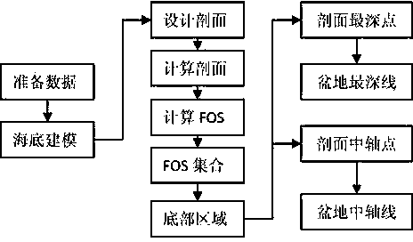
[0051] The technical flow chart that the example of the present invention completes sees figure 1 ;
[0052] Step 1: Prepare Data
[0053] 1.1) Organize data: if there is a water depth data set Among them, i and N dp is a natural number, dp i is the depth of water, N dp is the total number of sounding points, turn to step 2;
[0054] 1.2) Surveying and mapping data: If there is no water depth data in step 1.1), use a multi-beam bathymeter to conduct surveying and mapping in full-coverage detection mode and obtain a water depth data set Then go to step 2;
[0055] Step 2: Modeling the Seabed
[0056] Based on dataset Using the inverse distance weighting method to construct a digital model of seabed terrain m d and N d is the maximum row number and maximum column number of the model, j, M d and N d are natural numbers, dep i,j is t...
Embodiment 2
[0079] Taking an actual back-arc basin as an example to further illustrate the implementation process of this patent:
[0080] Step 1: Prepare Data
[0081] 1.1) Organize data: if there is a water depth data set Among them, i and N dp is a natural number, dp i is the depth of water, N dp is the total number of sounding points, turn to step 2;
[0082] 1.2) Surveying and mapping data: If there is no water depth data in step 1.1), use a multi-beam bathymeter to conduct surveying and mapping in full-coverage detection mode and obtain a water depth data set Then go to step 2;
[0083] Step 2: Modeling the Seabed
[0084] Based on dataset Using the inverse distance weighting method to construct a digital model of seabed terrain m d and N d is the maximum row number and maximum column number of the model, j, M d and N d are natural numbers, dep i,j is the water depth point of the model;
[0085] Step 3: Determine the bottom area
[0086] 3.1) Design section: verti...
PUM
 Abstract
Description
Claims
Application Information
 - R&D
- Intellectual Property
- Life Sciences
- Materials
- Tech Scout
- Unparalleled Data Quality
- Higher Quality Content
- 60% Fewer Hallucinations
Browse by: Latest US Patents, China's latest patents, Technical Efficacy Thesaurus, Application Domain, Technology Topic, Popular Technical Reports.
© 2025 PatSnap. All rights reserved.Legal|Privacy policy|Modern Slavery Act Transparency Statement|Sitemap|About US| Contact US: help@patsnap.com


