Urban building contour regularization method based on iteration minimum bounding rectangle

A technology for outsourcing rectangles and buildings, applied in the field of surveying, mapping and remote sensing, can solve the problems of data loss, large amount of calculation, and reduced accuracy, and achieve the effect of small data loss, strong adaptability, and small amount of calculation.

Inactive Publication Date: 2014-11-19
SHAANXI HUITU MAPPING GEOGRAPHIC INFORMATION CO LTD
View PDF2 Cites 15 Cited by
  • Summary
  • Abstract
  • Description
  • Claims
  • Application Information

AI Technical Summary

Problems solved by technology

[0002] As an important carrier of human activities and human civilization, buildings are the focus of current research in multiple disciplines. Rapid and accurate acquisition of building information plays an important role in urban planning, navigation, disaster assessment and other fields. It is important for rapid and accurate acquisition of building information Airborne laser three-dimensional scanning (Light Detection And Ranging, LiDAR) technology is commonly used. This technology integrates laser ranging system, global positioning system and inertial navigation system. It can quickly obtain three-dimensional space information on the earth's surface, with high efficiency and high elevation accuracy. , low cost and other characteristics, widely used in 3D digital city, urban planning, disaster assessment and other fields, the use of airborne LiDAR technology for building extraction and reconstruction is the current research hotspot and difficulty in the field of surveying, mapping and remote sensing, airborne LiDAR technology for building Information ex

Method used


Image

  • Urban building contour regularization method based on iteration minimum bounding rectangle
  • Urban building contour regularization method based on iteration minimum bounding rectangle
  • Urban building contour regularization method based on iteration minimum bounding rectangle

Examples


Embodiment Construction

[0025] The technical solutions of the present invention will be clearly and completely described below in conjunction with the accompanying drawings of the present invention. Apparently, the described embodiments are only some of the embodiments of the present invention, not all of them. Based on the embodiments of the present invention, all other embodiments obtained by persons of ordinary skill in the art without creative efforts fall within the protection scope of the present invention.

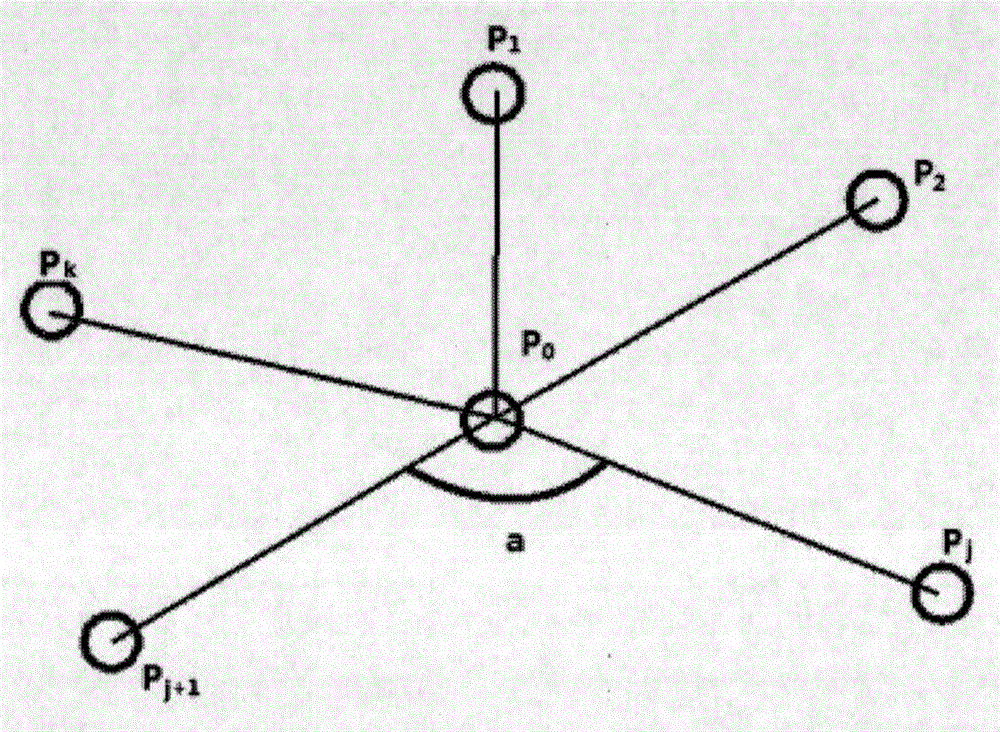
[0026] The present invention utilizes the airborne LiDAR technology to filter and classify building point cloud data obtained after building information is extracted, take the point cloud data and project it onto the XOY plane, and determine the grid spacing with twice the average point spacing. Carry out grid division, and detect its eight neighbors one by one. If there is a space grid unit in the neighborhood, the current grid unit is a boundary grid unit. Inside the boundary grid unit, s...


PUM


Abstract

The invention provides an urban building contour regularization method based on an iteration minimum bounding rectangle. On the basis that the urban modern building adjacent contour borders have an orthogonal property, after building information is filtered and extracted in a classified manner through the onboard LiDAR technology, the obtained building point cloud data is used as given data; regularization calculation is performed on contours of the most detected regular buildings on the basis of the minimum bounding rectangle. The urban building contour regularization method has the characteristics of less data loss, high adaptability, high accuracy and fewer operation amount, the building point cloud contours can be rapidly and accurately extracted, and the extracted data can be directly applied to the fields of urban planning, navigation, disaster evaluation and the like.

Description

technical field [0001] The invention relates to the technical field of surveying and mapping remote sensing, in particular to a method for regularizing urban building outlines based on iterative minimum enclosing rectangles. Background technique [0002] As an important carrier of human activities and human civilization, buildings are the focus of current research in multiple disciplines. Rapid and accurate acquisition of building information plays an important role in urban planning, navigation, disaster assessment and other fields. It is important for rapid and accurate acquisition of building information Airborne laser three-dimensional scanning (Light Detection And Ranging, LiDAR) technology is commonly used. This technology integrates laser ranging system, global positioning system and inertial navigation system. It can quickly obtain three-dimensional space information on the earth's surface, with high efficiency and high elevation accuracy. , low cost and other charac...

Claims


Application Information

Patent Timeline
IPC IPC(8): G06T7/60
Inventor 袁荣才王军仓郭舒蒋健刘江杨凡
Owner SHAANXI HUITU MAPPING GEOGRAPHIC INFORMATION CO LTD
Why Eureka
Try Eureka