System and method of inferring stratigraphy from suboptimal quality seismic images
A technology for stratigraphic and seismic information, used in seismology, seismic signal processing, measurement devices, etc.
- Summary
- Abstract
- Description
- Claims
- Application Information
AI Technical Summary
Problems solved by technology
Method used
Image
Examples
Embodiment Construction
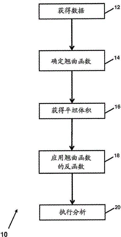
[0011] figure 1 A method 10 of inferring stratigraphy from a volume with seismic information is shown. For example, method 10 may be used in situations where the seismic imagery is of sub-optimal quality. Method 10 uses such seismic images to build higher fidelity stratigraphic structures. Method 10 may utilize the process of converting seismic image information back and forth into and out of a geographically temporally flattened space. The stratigraphic structure generated by method 10 can be used in seismic modeling.
[0012] Seismic information related to the subsurface volume is obtained in operation 12 . Seismic information may include one or more seismic images. Seismic images include three-dimensional seismic images in which magnitude information is indexed by spatial location. The spatial position is expressed as a position in two dimensions within a surface plane (eg, x-y plane) of the subsurface volume, and a metric related to position along an axis perpendicula...
PUM
 Abstract
Description
Claims
Application Information
 - R&D
- Intellectual Property
- Life Sciences
- Materials
- Tech Scout
- Unparalleled Data Quality
- Higher Quality Content
- 60% Fewer Hallucinations
Browse by: Latest US Patents, China's latest patents, Technical Efficacy Thesaurus, Application Domain, Technology Topic, Popular Technical Reports.
© 2025 PatSnap. All rights reserved.Legal|Privacy policy|Modern Slavery Act Transparency Statement|Sitemap|About US| Contact US: help@patsnap.com


