Remote sensing multispectral and panchromatic image fusion method based on mixed sub-pixel unmixing

A multi-spectral image, panchromatic image technology, applied in the field of remote sensing multi-spectral and panchromatic image fusion, can solve problems such as limiting practical applications

CN104933690BActive Publication Date: 2019-03-05INST OF REMOTE SENSING & DIGITAL EARTH CHINESE ACADEMY OF SCI
6 Cites 0 Cited by

Patent Information

Authority / Receiving Office
CN · China
Patent Type
Patents(China)
Current Assignee / Owner
Publication Date
2019-03-05

Smart Images

  • Figure 1
    Figure 1
  • Figure 2
    Figure 2
  • Figure 3
    Figure 3
Patent Text Reader

Abstract

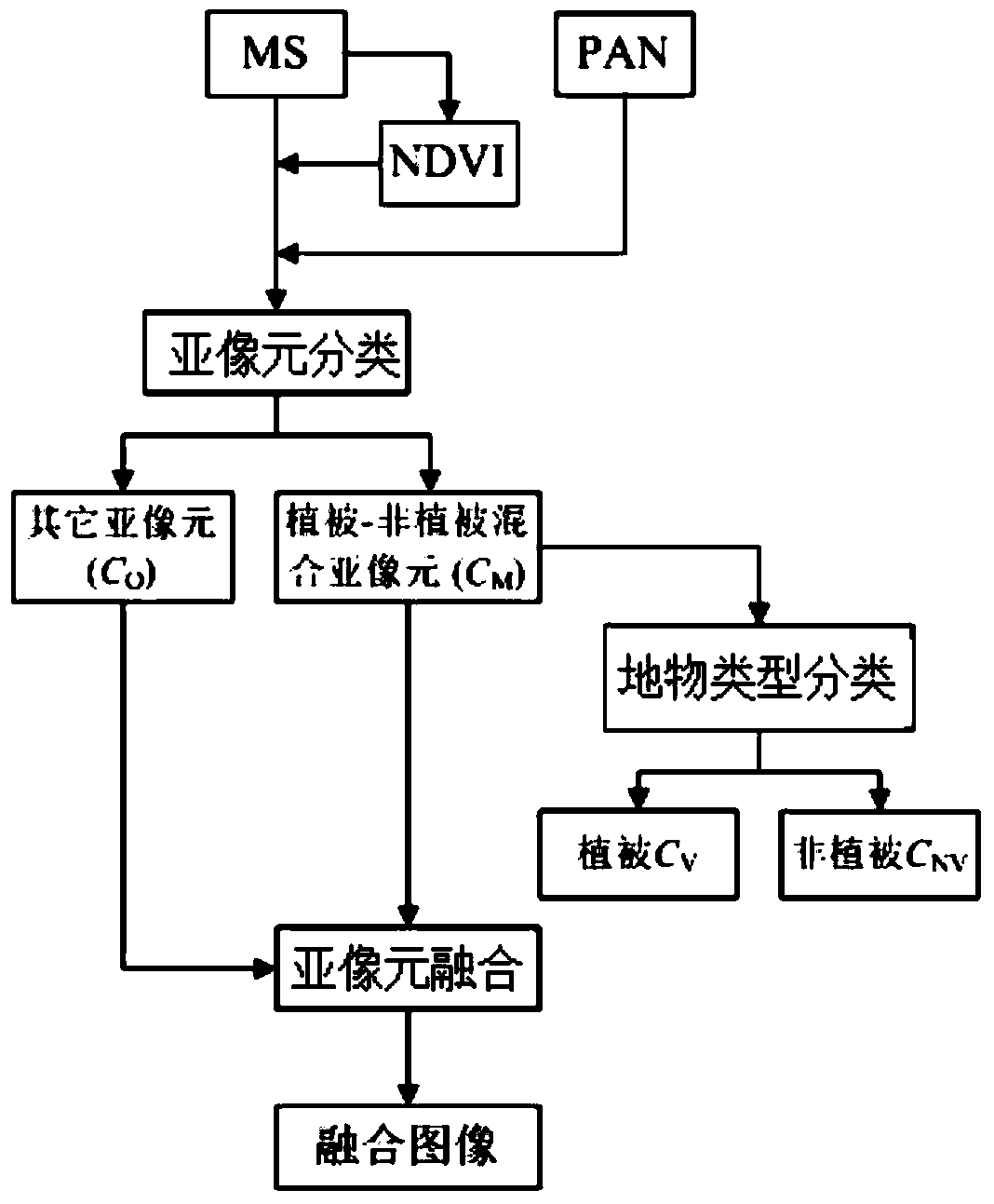
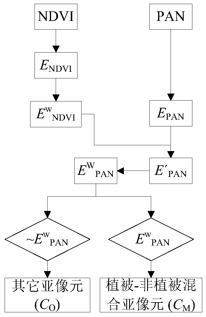
The invention discloses a remote sensing multi-spectral and panchromatic image fusion method based on mixed sub-pixel un-mixing, which comprises the steps of sampling the resolution of an original panchromatic image PAN from an original low-resolution multi-spectral image MS0 by adopting a cubic mode, and acquiring an MS image; calculating a normalized differential vegetation index NDVI based on the MS image; classifying sub-pixels in the MS image by using the original panchromatic image PAN and the normalized differential vegetation index NDVI, and acquiring a vegetation-non-vegetation mixed sub-pixel CM and other sub-pixels CO; judging the surface feature type of the vegetation-non-vegetation sub-pixel by using the original panchromatic image PAN and the normalized differential vegetation index NDVI; and carrying out fusion according to the corresponding sub-pixel type and the corresponding surface feature type as for each sub-pixel t n the MS image. The beneficial effects are that spectral un-mixing processing is carried out on the mixed sub-pixels in the multi-spectral image in the fusion process, so that the number of mixed pixels in a fusion image is reduced, the boundary of the fusion image is sharpened, and the spectral distortion is reduced.
Need to check novelty before this filing date? Find Prior Art

Description

technical field

[0001] The invention relates to the technical field of remote sensing image processing, in particular to a remote sensing multispectral and panchromatic image fusion method based on mixed sub-pixel unmixing. Background technique

[0002] Remote sensing data fusion is to synthesize the information provided by different sensor data to obtain a more comprehensive and accurate image. limitations, which facilitates image interpretation, classification, and object recognition. With the development of aerospace, sensor, and communication technologies, the spatial, spectral, and temporal resolutions of remote sensing data are rapidly improving. Due to the limitations of the sensor's physical characteristics and data transmission capabilities, it is difficult to simultaneously acquire high spatial resolution and high spectral spatial resolution images. Therefore, a large number of satellites currently in orbit (such as Landsat 7ETM+, QuickBird, SPOT-5 and WorldView-...

Examples

Embodiment Construction

[0034] The following will clearly and completely describe the technical solutions in the embodiments of the present invention with reference to the accompanying drawings in the embodiments of the present invention. Obviously, the described embodiments are only some, not all, embodiments of the present invention. All other embodiments obtained by persons of ordinary skill in the art based on the embodiments of the present invention belong to the protection scope of the present invention.

[0035] According to an embodiment of the present invention, a remote sensing multispectral and panchromatic image fusion method based on mixed sub-pixel unmixing is provided.

[0036] Such as Figure 1-2 As shown, the remote sensing multispectral and panchromatic image fusion method based on mixed sub-pixel unmixing according to an embodiment of the present invention includes the following steps:

[0037] 1. The original low-resolution MS image (MS 0 )Use cubic (cubic convolution) method to...