A method for rapid integration and display of bim model and 3D geographic information system

A technology of geographic information system and model, applied in the field of rapid integration and presentation of BIM model and 3D geographic information system, can solve the problems of information loss, BIM model delivery limitation, loss of geometric size information and attribute information, etc., and achieve the effect of solving information loss.

Active Publication Date: 2018-10-16
KUNMING ANTAIDE SOFTWARE CO LTD
View PDF3 Cites 0 Cited by
  • Summary
  • Abstract
  • Description
  • Claims
  • Application Information

AI Technical Summary

Problems solved by technology

[0004] When the BIM model is applied to the field of civil engineering, it must be combined with geographic information. However, at this stage, due to the integration of the BIM model into the 3D geographic information system, the information carried by the BIM model is lost, the loading speed is slow, and the spatial position of the components in the building (structure) is biased. Issues such as shifting: First, from the BIM model design stage, due to the use of different BIM design software by each profession, there are platform limitations in the delivery of BIM models; second, the planar coordinate system is used in BIM model design, and spherical coordinates are generally used in 3D geographic information systems system; BIM models focus on the spatial relationship of components in a single building (structure). If multiple single BIM models are directly projected to a spherical 3D geographic information system according to the original plane coordinates, there will be multiple single BIM models. The model and the components in the single BIM model cannot be spliced ​​and displaced; the third is that the BIM model is generally relatively fine, and if it is not lightweight, the massive BIM model cannot be carried by the current 3D geographic information system; the fourth is the BIM model If it is directly imported and loaded into the 3D geographic information system in the traditional way, the geometric dimension information and attribute information will be lost

Method used


Image

  • A method for rapid integration and display of bim model and 3D geographic information system

Examples


Embodiment Construction

[0016] The following will clearly and completely describe the technical solutions in the embodiments of the present invention with reference to the accompanying drawings in the embodiments of the present invention. Obviously, the described embodiments are only some, not all, embodiments of the present invention.

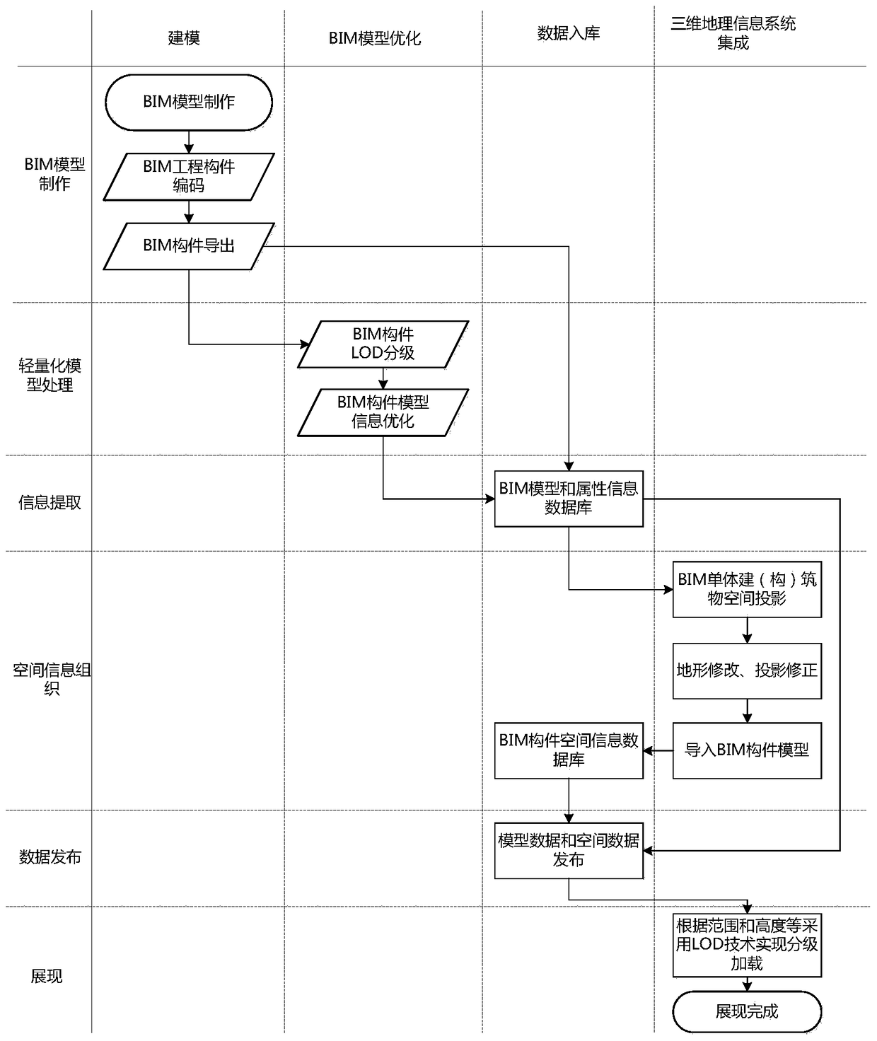
[0017] Refer to attached figure 1 , a method for rapid integration and display of BIM models and 3D geographic information systems, the steps are as follows:

[0018] The first step is to code the component model according to the project division when making the BIM model. For example, the BIM components of road or housing construction are coded according to the WBS (Work Breakdown Structure, Work Breakdown Structure) project division standard, and the railway project is coded according to the EBS (Engineering Breakdown Structure). , Engineering System Breakdown Structure) for encoding. According to the algorithm, calculate the direction and distance between each co...


PUM


Abstract

The present invention discloses a method for rapid integrated presentation of a BIM model and a three-dimensional geographical information system. The method comprises: encoding a BIM model; performing weight reduction on the BIM model, and extracting and importing attribute information; projecting the BIM model into a three-dimensional geographical information system according to design coordinates; reorganizing the BIM model according to a spherical coordinate system, and re-importing the reorganized BIM model; and after releasing the BIM model, querying spatial geometry information and attribute information of the BIM model in the three-dimensional geographical information system. According to the method disclosed by the present invention, a digitized three-dimensional architectural model is used as a core during design and construction of architectural engineering, and the BIM design model is well applied to the field of civil engineering and is combined with geographical information, thereby solving the problems such as that when the BIM design model is integrated into the three-dimensional geographical information system, carried information is missing, a loading speed is slow, and spatial positions of members in buildings or structures are shifted.

Description

technical field [0001] The invention relates to BIM technology, three-dimensional geographic information technology and database management technology, in particular to a method for rapidly integrating and presenting a BIM model and a three-dimensional geographic information system. Background technique [0002] BIM (Building Information Modeling, referred to as BIM) is a digital tool applied to engineering design, construction and management. It is based on three-dimensional digital technology and integrates various related information of construction engineering data models. It is a detailed expression of construction project-related information, supports an integrated management environment for construction project design, construction, and management, and is shared and transmitted during the entire life cycle of project planning, operation, and maintenance. It has the characteristics of visualization, coordination, simulation and plotting. In the construction industry, ...

Claims


Application Information

Patent Timeline
Patent Type & Authority Patents(China)
IPC IPC(8): G06F17/50G06F17/30
CPCG06F16/29G06F30/13
Inventor 张自震陈绍林张芦川梁志福李建崔华勇
Owner KUNMING ANTAIDE SOFTWARE CO LTD
Why Eureka
Try Eureka