Simultaneous localization and mapping and inertial navigation combined error fusion system

A technology of inertial navigation and combined errors, applied in the direction of measuring devices, instruments, etc., can solve problems such as increasing errors in mapping and azimuth recognition, increasing feedback delays, affecting robot positioning and navigation functions, etc.

Inactive Publication Date: 2017-07-21
SHANDONG UNIV
View PDF4 Cites 14 Cited by
  • Summary
  • Abstract
  • Description
  • Claims
  • Application Information

AI Technical Summary

Problems solved by technology

However, lidar is limited by scanning time and range. As the robot moves faster, the feedback delay increases, and the errors in mapping and orientation recognition gradually increase until effective modeling is impossible, which seriously affects the positioning and navigation of the robot.

Method used


Image

  • Simultaneous localization and mapping and inertial navigation combined error fusion system
  • Simultaneous localization and mapping and inertial navigation combined error fusion system
  • Simultaneous localization and mapping and inertial navigation combined error fusion system

Examples


Embodiment 1

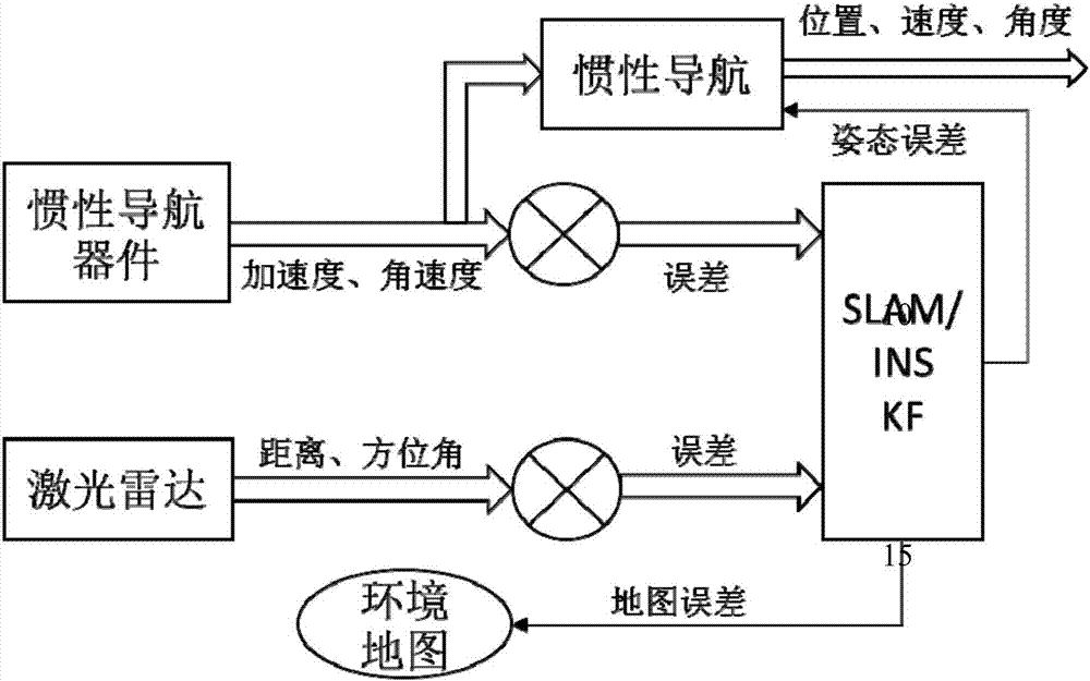
[0074] The present invention mainly aims at robot intelligent carrying and navigation, and has invented a combined error fusion system of concurrent mapping positioning and inertial navigation. The device and its operation flow chart are as follows figure 1 as shown,

[0075] A combined error fusion system for concurrent mapping and positioning and inertial navigation, including a carrier, an inertial navigation device, a concurrent mapping and positioning device, and an error fusion device; the inertial navigation device includes an accelerometer, a gyroscope, and an inertial navigation drive device, the concurrent mapping positioning device includes a laser radar and an environmental map construction device; the error fusion device includes a linear discrete concurrent mapping positioning error module, an inertial navigation error module and a weighted fusion module;

[0076] In the inertial navigation device, the accelerometer obtains the acceleration of the vehicle, the g...


PUM


Abstract

The invention belongs to the field of intelligent navigation devices and discloses a simultaneous localization and mapping and inertial navigation combined error fusion system. The system comprises a carrier, an inertial navigation device, a simultaneous localization and mapping device and an error fusion device. The inertial navigation device comprises an accelerometer, a gyroscope and an inertial navigation driving device. The simultaneous localization and mapping device comprises laser radar and an environment map building device. The error fusion device comprises a linear discrete simultaneous localization and mapping error module, an inertial navigation error module and a weight fusion module. Therefore, high accuracy and reliability in positioning and navigation of robots can be realized.

Description

technical field [0001] The invention belongs to the field of intelligent navigation devices, and in particular relates to a combined error fusion system of concurrent mapping positioning and inertial navigation. Background technique [0002] In recent years, inertial navigation (INS for short) has given full play to its own advantages in some land areas that cannot be detected by navigation systems such as satellite navigation. The strapdown inertial navigation system in the prior art is composed of an accelerometer and a gyroscope, which are installed on a carrier to calculate the acceleration information and angular velocity information of the carrier respectively. However, in practical applications, due to the singleness of the sensor of the strapdown inertial navigation module, navigation errors occur frequently and will accumulate and magnify. [0003] Concurrent Mapping and Localization (also known as Simultaneous Localization and Mapping, or SLAM for short) is consid...

Claims


Application Information

Patent Timeline
Patent Type & Authority Applications(China)
IPC IPC(8): G01C25/00
CPCG01C25/005
Inventor 姜向远任鹏许敏
Owner SHANDONG UNIV
Why Eureka
Try Eureka