High-integration beidou satellite geological disaster professional monitoring station

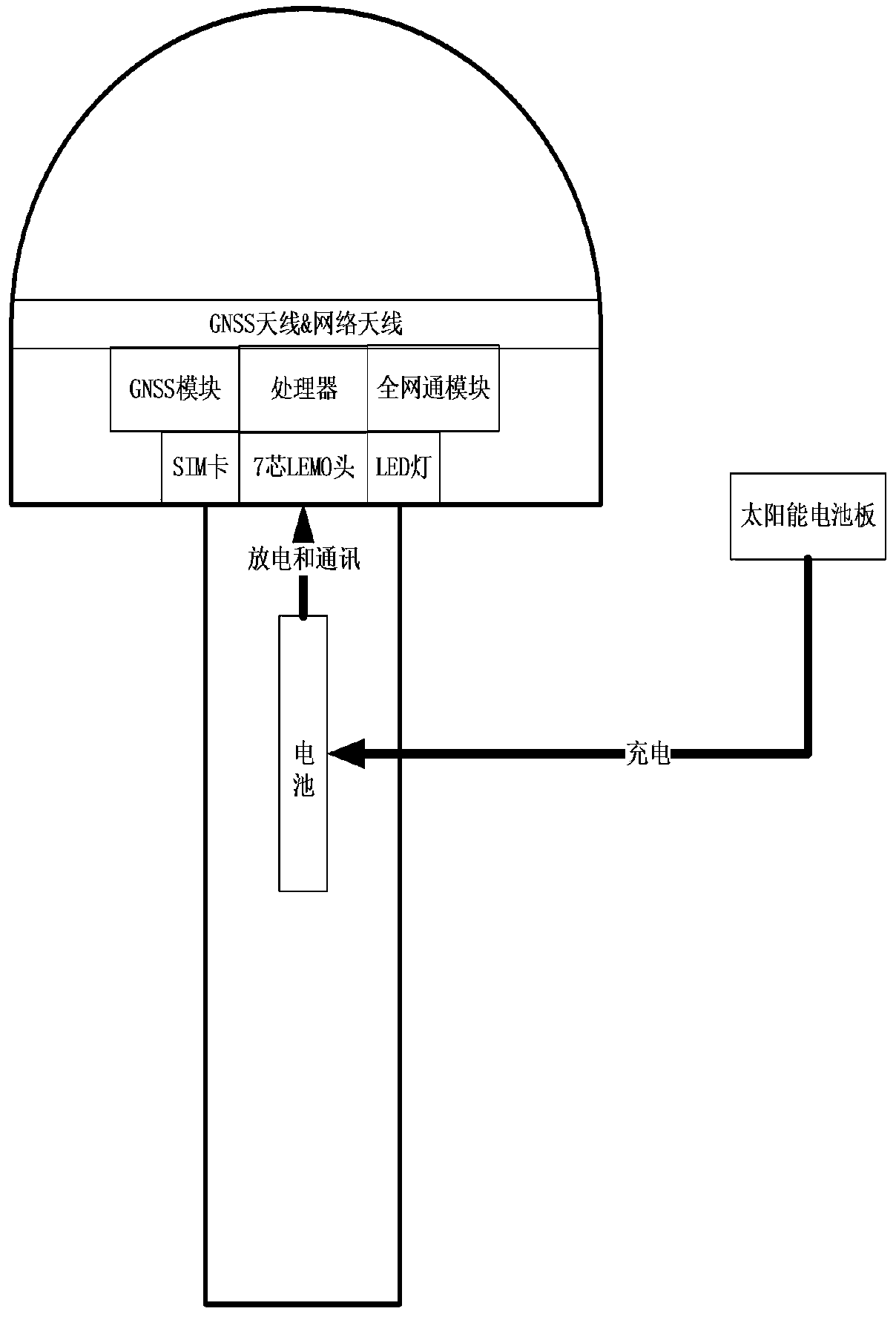
A Beidou satellite, highly integrated technology, used in satellite radio beacon positioning systems, measurement devices, radio wave measurement systems, etc. Signal reception and transmission capability, extending battery life, reducing the effect of manual installation

Pending Publication Date: 2019-08-16
SHANGHAI HUACE NAVIGATION TECH
View PDF6 Cites 1 Cited by
  • Summary
  • Abstract
  • Description
  • Claims
  • Application Information

AI Technical Summary

Problems solved by technology

[0003] 1. Problems with the power supply system: the system is set up in the field, and the geographical location is complex. Most of the batteries are powered by lead-acid batteries. A lead-acid battery that meets the battery life weighs about 20kg, which is not conducive to transportation in complex terrain.
[0004] 2. Satellite receiver problem: At present, the realization of high-precision positioning monitoring function requires two parts, one is the GNSS receiver, and the other is the antenna
Low integration comes with high installation complexity

Method used


Image

  • High-integration beidou satellite geological disaster professional monitoring station

Examples


Embodiment Construction

[0014] The following will clearly and completely describe the technical solutions in the embodiments of the present invention with reference to the accompanying drawings in the embodiments of the present invention. Obviously, the described embodiments are only some, not all, embodiments of the present invention. Based on the embodiments of the present invention, all other embodiments obtained by persons of ordinary skill in the art without making creative efforts belong to the protection scope of the present invention.

[0015] In the description of the present invention, it should be noted that the terms "upper", "lower", "inner", "outer", "front end", "rear end", "both ends", "one end", "another end" The orientation or positional relationship indicated by etc. is based on the orientation or positional relationship shown in the drawings, and is only for the convenience of describing the present invention and simplifying the description, rather than indicating or implying that ...


PUM


Abstract

The invention discloses a high-integration beidou satellite geological disaster professional monitoring station. The high-integration beidou satellite geological disaster professional monitoring station comprises a GNSS receiver, wherein the GNSS receiver comprises a main circuit board, an antenna and an external interface; the main circuit board comprises a power supply system, a processor, a network module and a high-precision satellite positioning module; the antenna comprises a GNSS antenna and a network antenna; and the main circuit board is provided with a GNSS antenna interface and a network antenna interface which are used for being connected with the antenna. An existing beidou geological disaster monitoring system is highly integrated, and the manual installation and maintenancedifficulty is lowered; on the basis of a traditional monitoring scheme, a base cabinet and an antenna cover are removed, and the endurance time of the system is prolonged. The monitoring station is erected in a complex field terrain, and the manual transportation difficulty is lowered, so that the all-ground, all-weather, low-cost, high-precision and high-integration simple geological disaster monitoring system can be realized.

Description

technical field [0001] The invention relates to the application of satellite systems such as Beidou and GPS, geographical surveying and mapping, and the fields of geological disaster monitoring, in particular to a highly integrated Beidou satellite geo-disaster professional monitoring station. Background technique [0002] Beidou satellite geological monitoring has been fully applied in the market, and the technical solutions adopted are mostly high-precision RTK receivers, independent GNSS antennas (requires radome to fix and protect the antennas), suction cup network antennas (used for effective data remote transmission through the network) ) composed of satellite receiving function, the power supply system is composed of solar panels and lead-acid batteries. This solution can achieve the purpose of monitoring in practical applications, but it has low integration, high power consumption, and bulky system. Mainly manifested in two major aspects: [0003] 1. Problems with ...

Claims


Application Information

Patent Timeline
Patent Type & Authority Applications(China)
IPC IPC(8): G01S19/14
CPCG01S19/14
Inventor 李翔杨荣仕陈林廉绍康黄晔丁鹏赵斐斐朱磊
Owner SHANGHAI HUACE NAVIGATION TECH
Why Eureka
Try Eureka