Spatial position data processing method and system

A technology of spatial location and processing methods, which is applied in special data processing applications, geographic information databases, structured data retrieval, etc., and can solve problems such as unmeasured uncertainty in analysis and application work, and less consideration of data quality issues, etc.

Inactive Publication Date: 2020-02-25
HUAZHONG UNIV OF SCI & TECH
View PDF4 Cites 1 Cited by
  • Summary
  • Abstract
  • Description
  • Claims
  • Application Information

AI Technical Summary

Problems solved by technology

[0004] Aiming at the defects of the existing technology, the purpose of the present invention is to solve the current research and application of location-based big data. In the data preprocessing link,

Method used


Image

  • Spatial position data processing method and system
  • Spatial position data processing method and system
  • Spatial position data processing method and system

Examples


Embodiment Construction

[0064] In order to make the object, technical solution and advantages of the present invention clearer, the present invention will be further described in detail below in conjunction with the accompanying drawings and embodiments. It should be understood that the specific embodiments described here are only used to explain the present invention, not to limit the present invention. In addition, the technical features involved in the various embodiments of the present invention described below can be combined with each other as long as they do not constitute a conflict with each other.

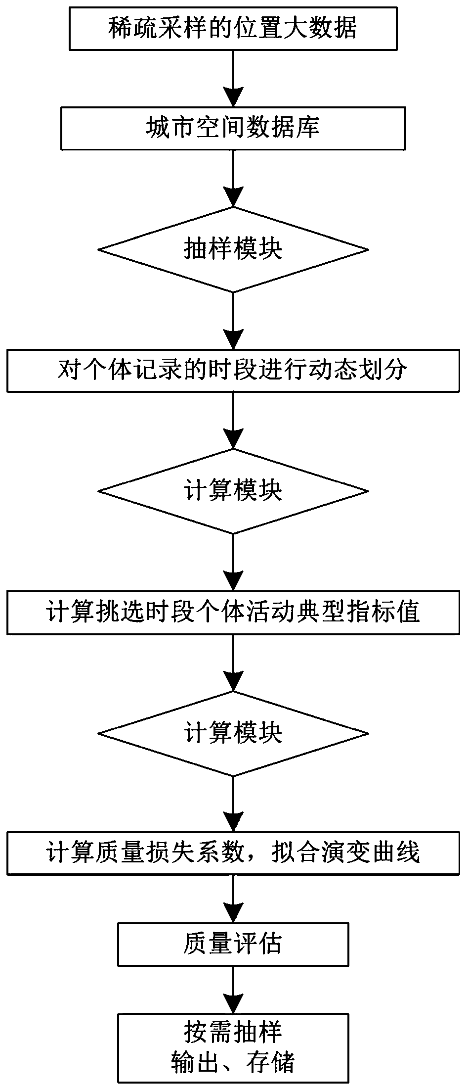
[0065] Aiming at the lack of standardization and uncertainty in the preprocessing and use of the existing spatial position big data, the present invention introduces the basic format of the spatial position big data and its sparse sampling problem, and uses data sampling points on this basis Space-time distribution, an intuitive and effective inherent feature, divides the time periods in the sam...


PUM


Abstract

The invention discloses a spatial position data processing method and system. Firstly, quality evaluation is performed on sparse sampled spatial position big data on space-time sampling; therefore, the method starts from the basic characteristic of inherent space-time distribution in individual position big data of sparse sampling; through dynamic period division, computer random simulation and calculation and regression analysis, a quantitative loss evaluation model for describing typical characteristics of urban resident activities by aiming at sparse sampling spatial position big data is provided, and quality loss distribution characteristics corresponding to different sampling rates are clearly explained. Finally, the sample data set meeting the actual requirements is selected according to the distribution of the obtained deviations, so that the conclusion of related research and analysis is more reliable, and the actual application is guided more scientifically.

Description

technical field [0001] The present invention relates to the technical field of spatial location data processing, and more particularly, to a processing method and system for spatial location data. Background technique [0002] The rapid development of technologies such as communication and information technology and location-aware technology helps to collect large-scale individual spatial location movement data and share information in a relatively low-cost, large-scale, and very fast manner, with time stamps and spatial Big data on location coordinates is within reach. Spatio-temporal big data is applied in the fields of dynamic analysis of urban residents' movement, spatio-temporal pattern mining, traffic analysis, and urban planning. Data quality issues will be involved. [0003] Sparsely sampled location big data is an important data source currently involved in urban spatial analysis research and applications, such as mobile phone signaling spatiotemporal location dat...

Claims


Application Information

Patent Timeline
IPC IPC(8): G06F16/29G06F17/18
CPCG06F17/18G06F16/29
Inventor 鲁仕维黄亚平
Owner HUAZHONG UNIV OF SCI & TECH
Why Eureka
Try Eureka