Supercharge Your Innovation With Domain-Expert AI Agents!

A Scattering Multi-Wave Advance Detection Method Based on Vertical Virtual Survey Line of Roadway

A technology of advanced detection and scattered waves, which can be used in measurement devices, geophysical measurements, seismology, etc., and can solve the problems of imaging artifacts, incomplete wave field signals, and limiting the accuracy of advanced detection.

Active Publication Date: 2021-11-23
CHINA UNIV OF MINING & TECH
View PDF0 Cites 0 Cited by
  • Summary
  • Abstract
  • Description
  • Claims
  • Application Information

AI Technical Summary

Problems solved by technology

However, under the special geological conditions of mines, complex and irregular small-scale geological anomalies, such as small faults, collapse columns, etc., are often faced. Such geological anomalies usually generate abundant scattered waves and are difficult to form obvious reflections. Waves, the scattered waves derived from the Huygens-Fresnel principle cover all types of waves, which are more suitable for the detection of small-scale complex and uneven mine geological structures than reflected waves; at the same time, the acquisition environment of complex roadways and narrow spaces (coal The height and width of the roadway section are usually 3-5m), and the depth of the explosive-induced borehole is only 1.5-2m, resulting in a very small lateral offset perpendicular to the advance detection direction of the roadway, and the collected wave field signals are far from complete; finally, In the three-dimensional space of the roadway, the aliasing of different types of seismic waves in different directions will cause imaging artifacts and limit the accuracy of advanced detection

Method used


Image

  • A Scattering Multi-Wave Advance Detection Method Based on Vertical Virtual Survey Line of Roadway
  • A Scattering Multi-Wave Advance Detection Method Based on Vertical Virtual Survey Line of Roadway
  • A Scattering Multi-Wave Advance Detection Method Based on Vertical Virtual Survey Line of Roadway

Examples


Embodiment Construction

[0051] The present invention will be further described below.

[0052] As shown in the figure, the concrete steps of the present invention are:

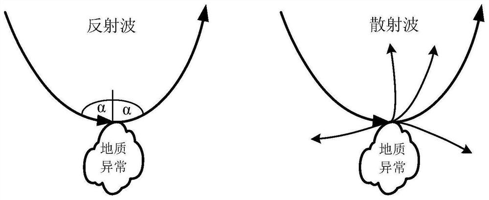
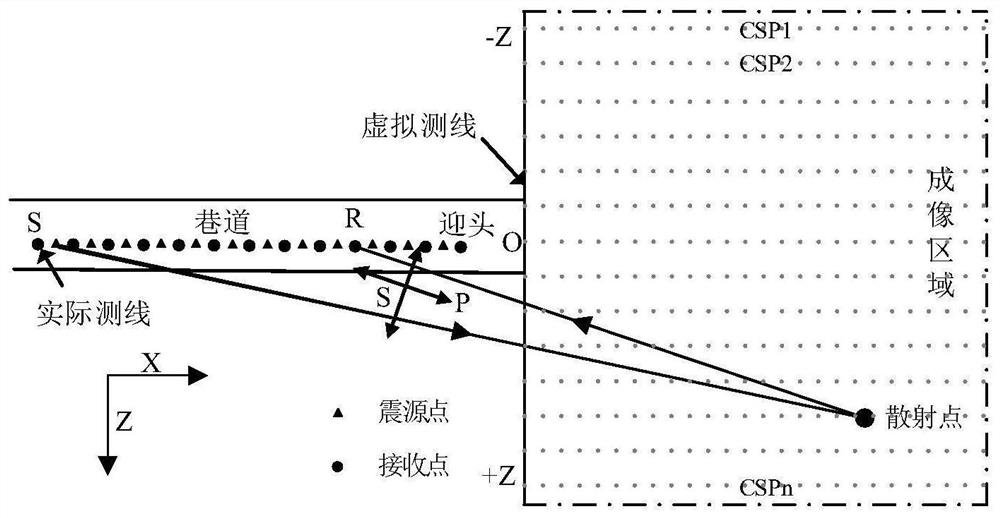
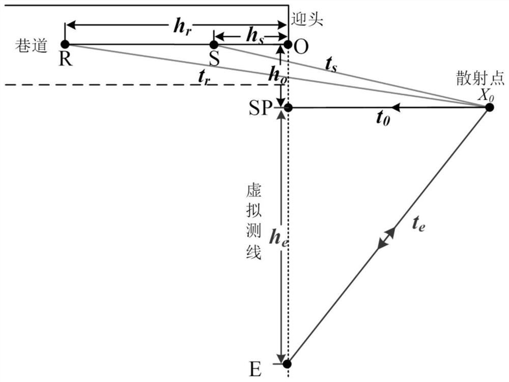
[0053] Step 1: Arrange multiple three-component geophones along the direction of the roadway in any of the two sides of the roadway behind the front of the roadway. The X direction of the three-component geophone is the roadway excavation direction, the Y direction is the roadway horizontal direction, and the Z direction is perpendicular to The direction of the roof and the bottom plate; the distance between multiple three-component geophones is 2m and they are on the same horizontal plane, and the multiple three-component geophones are connected to the seismograph; a seismic source is arranged at the middle point of every two three-component geophones Then the seismic source excites seismic waves to the side in turn, and at this time, multiple three-component geophones receive the seismic wave signals of each seismic source respecti...


PUM


Abstract

The invention discloses a scattering multi-wave advanced detection method based on the vertical virtual survey line of the roadway. First, a row of three-component geophones is arranged, and then a seismic source is arranged at the midpoint between adjacent geophones, and then the seismic sources are excited sequentially. At this time, multiple geophones receive the seismic wave signals of each source respectively; determine the position of the virtual survey line and the imaging range of the vertical virtual survey line; then set the equivalent self-excitation and self-retraction point E, and then calculate the isochronous offset distance h e ; Analyze the polarization of the three-component signal of the detector to obtain the polarization filter function; then use this function to vector-filter the signal to obtain different types of equivalent scattered wave signals of each common scattering point in the imaging area, and combine the isochronous polarization The common scattering point gathers are formed by shifting the distance; the velocity analysis of the equivalent scattered wave signals of each common scattering point gather is carried out, and then the zero offset records of each gather are obtained; finally, the zero offset records are rearranged, Different types of scattered wave imaging sections based on vertical virtual survey lines are formed.

Description

technical field [0001] The invention relates to a mine roadway advanced detection method, in particular to a scattering multi-wave advanced detection method based on the vertical virtual survey line of the roadway. Background technique [0002] Roadway excavation is one of the key stages of coal mine production, and it is also a stage where safety accidents are prone to and frequently occur, and 76% of serious accidents in coal mines occur here. Therefore, accurate detection of abnormal geological structures in front of the roadway is an inevitable requirement to ensure safe production in coal mines. Therefore, how to further improve the accuracy of advanced detection of roadway structures has become a realistic demand goal pursued by industry colleagues. [0003] Structural advance detection usually uses the arrangement of seismic sources (explosives, sledgehammers, etc.) and receiving systems (various three-component geophones) in the roadway, and the seismic waves are sti...

Claims


Application Information

Patent Timeline
Patent Type & Authority Patents(China)
IPC IPC(8): G01V1/18G01V1/20G01V1/30G01V1/34G01V1/36
CPCG01V1/184G01V1/20G01V1/306G01V1/345G01V1/364G01V2210/16G01V2210/20G01V2210/624G01V2210/74
Inventor 章俊刘盛东靖洪文王勃刘惠洲李纯阳孙华超
Owner CHINA UNIV OF MINING & TECH
Features
  • R&D
  • Intellectual Property
  • Life Sciences
  • Materials
  • Tech Scout
  • Unparalleled Data Quality
  • Higher Quality Content
  • 60% Fewer Hallucinations
Learn More