Supercharge Your Innovation With Domain-Expert AI Agents!

Autocad block and point map symbol exchange method based on path

A technology of map symbols and blocks, applied in the direction of drawing from basic elements, special data processing applications, instruments, etc., can solve the problem of isomerism of point symbols in maps

Inactive Publication Date: 2011-12-21
NANJING NORMAL UNIVERSITY
View PDF4 Cites 4 Cited by
  • Summary
  • Abstract
  • Description
  • Claims
  • Application Information

AI Technical Summary

Problems solved by technology

[0007] The purpose of the present invention is to overcome the defects existing in the sharing of existing map symbols, solve the heterogeneous problem of point symbols in maps, and propose AutoCAD block and point map based on paths on the basis of path-based point map symbol data models. Symbol (referred to as VGE point map symbol) exchange method, providing bidirectional mapping between AutoCAD blocks and path-based point map symbols, realizing the assimilation and sharing of point map symbols

Method used


Image

  • Autocad block and point map symbol exchange method based on path
  • Autocad block and point map symbol exchange method based on path
  • Autocad block and point map symbol exchange method based on path

Examples


Embodiment 1

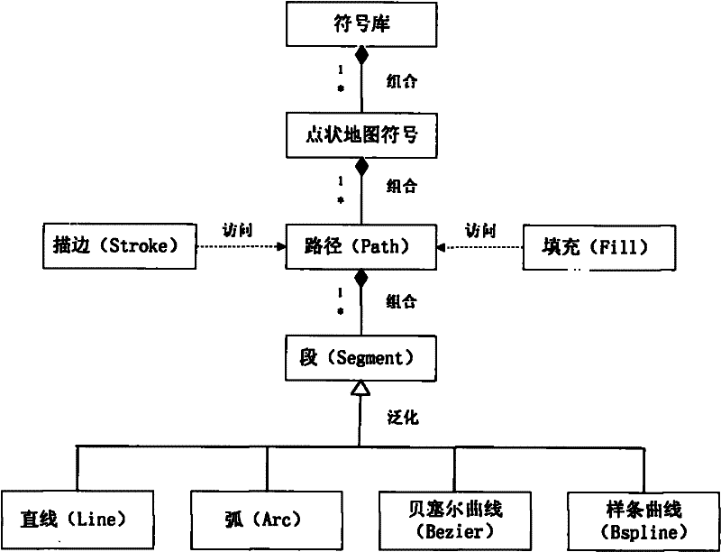
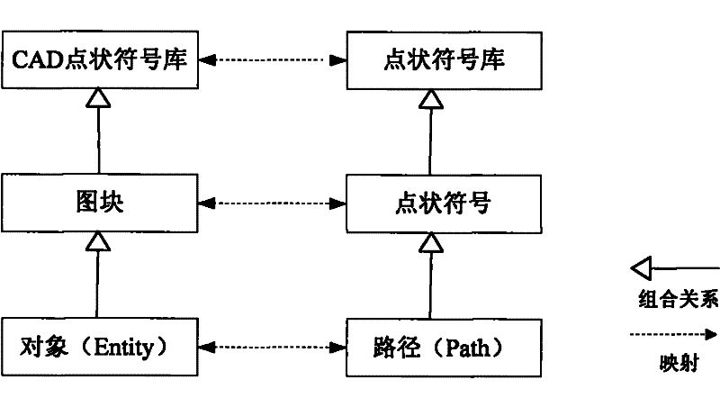
[0030] Such as figure 2 As shown, the method of exchanging AutoCAD blocks and path-based point map symbols, this method includes two parts: the conversion of AutoCAD blocks to path-based point map symbols and the conversion of path-based point map symbols to AutoCAD blocks.

[0031] The conversion of AutoCAD blocks to path-based point map symbols includes the following steps:

[0032] Step 1, AutoCAD block interpretation;

[0033] Step 2, AutoCAD block classification;

[0034] Step 3, AutoCAD blocks are mapped to path-based point map symbols.

[0035] This example uses Windows XP SP3 as the operating system environment, Visual Studio 2008 SP1 as the development environment, C++ as the development language, AutoCAD 2008 as the CAD platform, and the AutoCAD point map symbols are stored in the form of blocks.

[0036] The specific implementation steps are as follows:

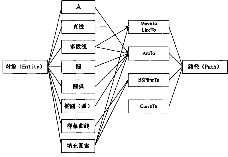
[0037]Step 1 Interpretation of AutoCAD blocks refers to identifying the AutoCAD files that need to be excha...


PUM


Abstract

The invention discloses a method for exchanging AutoCAD block and path-based point map symbols. The method includes two parts: the conversion of AutoCAD block to path-based point map symbols, and the conversion of path-based point map symbols to AutoCAD block. The conversion of AutoCAD blocks to path-based point map symbols refers to the interpretation of AutoCAD blocks, and then the classification of AutoCAD block data according to geometric shapes, and finally the mapping of AutoCAD block entity objects to path-based point map symbols. The transformation of path-based point map symbols into AutoCAD blocks refers to the interpretation of path-based point map symbols, and then the path-based point map symbols are classified according to geometric shapes, and finally the path-based point map symbols are mapped to AutoCAD blocks.

Description

technical field [0001] The invention relates to the field of geographic information sharing, in particular to a method for exchanging AutoCAD block and path-based point map symbols. Background technique [0002] Geographic information sharing refers to the common use of geographic information based on hardware technologies such as computers and spatial data infrastructure, and supported by soft environments such as standards, policies, and laws. Map symbols are the main tool for spatial data visualization. It stimulates the left brain of people through pictographic and comprehensible graphics to generate mental images to convey information such as the characteristics and distribution rules of geographical entities. [0003] The existing geographic information sharing technology rarely considers the sharing of map symbol information, and even if it does, the effect is not ideal, especially how to share symbols between CAD and GIS has always been a difficult problem for everyo...

Claims


Application Information

Patent Timeline
Patent Type & Authority Patents(China)
IPC IPC(8): G06T11/20G06F17/30
Inventor 陈泰生温永宁吴明光闾国年盛业华
Owner NANJING NORMAL UNIVERSITY
Features
  • R&D
  • Intellectual Property
  • Life Sciences
  • Materials
  • Tech Scout
  • Unparalleled Data Quality
  • Higher Quality Content
  • 60% Fewer Hallucinations
Learn More