GPS aided positioning system and method based on multi-sensor data fusion

An auxiliary positioning system and data fusion technology, which is applied in the field of navigation and positioning, can solve problems such as the inability to meet positioning accuracy requirements, and achieve the effect of improving accuracy and precise positioning data.

Inactive Publication Date: 2010-12-08
陶洋
View PDF3 Cites 52 Cited by
  • Summary
  • Abstract
  • Description
  • Claims
  • Application Information

AI Technical Summary

Problems solved by technology

[0007] Therefore, a single navigation system cannot meet th...

Method used


Image

  • GPS aided positioning system and method based on multi-sensor data fusion
  • GPS aided positioning system and method based on multi-sensor data fusion
  • GPS aided positioning system and method based on multi-sensor data fusion

Examples


Embodiment Construction

[0055] Preferred embodiments of the present invention will be described in detail below.

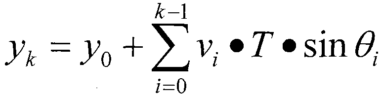
[0056] see figure 1 , the GPS-assisted positioning system based on multi-sensor data fusion in this embodiment includes a GPS navigation system, a gyroscope and accelerometer combined system, a data processing and fusion module, and a map matching module.

[0057] The GPS navigation system consists of a GPS module and its data acquisition and processing module, which is used to obtain the GPS positioning information of the carrier, including position, speed, time, number of satellites, and position accuracy strength data; the basic principle of GPS positioning technology is The instantaneous position of the high-speed moving satellite is used as the known starting data. The satellite continuously sends its own ephemeris parameters and time information. The three-dimensional position of the machine. Specifically, assuming that the user's receiver measures the distances d1, d2, and d3 fr...


PUM


Abstract

The invention relates to the technical field of navigation positioning, particularly to a navigation positioning technique based on multi-sensor data fusion. A GPS aided positioning system based on multi-sensor data fusion comprises a GPS navigation system, a gyroscope and accelerometer combined system, a data processing and fusion module and a map-matching module, wherein the GPS navigation system comprises a GPS module and a data collecting and processing module thereof and is used for acquiring the data of a carrier, such as GPS position, speed, time, number of satellites, and the degree of position accuracy; the gyroscope and accelerometer combined system comprises a gyroscope, an accelerometer and a data collecting and processing module and is used for acquiring the angular velocity,the speed and the accelerated speed of the carrier; the data processing and fusion module integrates the data acquired by the GPS navigation system and the gyroscope and accelerometer combined systemso as to obtain the position information of the carrier; and the map-matching module corrects the error of position information of the carrier outputted by a digital electronic map and the data processing and fusion module so as to obtain the final position information of the carrier. The invention also provides a GPS aided positioning method based on multi-sensor data fusion.

Description

technical field [0001] The invention relates to the technical field of navigation and positioning, in particular to a navigation and positioning technology based on multi-sensor data fusion. Background technique [0002] Most of the existing navigation and positioning technologies are single navigation systems. [0003] For example, the most commonly used GPS (Global Positioning System) system, the GPS system is a radio navigation system, as the first high-tech applied to the navigation and positioning system, it has the ability to provide users with continuous positioning at any time and under any weather conditions worldwide. The characteristics of continuous high-precision three-dimensional position, speed and time information, high navigation accuracy, does not diverge with time, that is, good long-term stability. [0004] However, GPS positioning depends on the satellite constellation seen by the receiver, so in some specific environments, the GPS receiver loses signal...

Claims


Application Information

Patent Timeline
IPC IPC(8): G01S19/10G01S19/47
Inventor 陶洋黄宏程万俊任步廷鲁贝贝
Owner 陶洋
Why Eureka
Try Eureka