Ground control and measurement stationing method based on onboard interferometric synthetic aperture radar (InSAR)

A technology for ground control and control points, which is used in measurement devices, radio wave measurement systems, and radio wave reflection/re-radiation to achieve the effects of speeding up the mapping speed, easy operation and high mapping accuracy

Inactive Publication Date: 2012-10-03
XIAN MEIHANG INFORMATION IND
View PDF6 Cites 19 Cited by
  • Summary
  • Abstract
  • Description
  • Claims
  • Application Information

AI Technical Summary

Problems solved by technology

[0010] The technical problem to be solved by the present invention is to provide an airborne InSAR-based ground control measurement point distribution method for the above-mentioned deficiencies in the prior art. Control points, reduce production costs and speed up mapping, make up for the lack of technical specifications of existing traditional optical systems that cannot guide airborne interferometric synthetic aperture radar topographic mapping control measurement

Method used


Image

  • Ground control and measurement stationing method based on onboard interferometric synthetic aperture radar (InSAR)
  • Ground control and measurement stationing method based on onboard interferometric synthetic aperture radar (InSAR)
  • Ground control and measurement stationing method based on onboard interferometric synthetic aperture radar (InSAR)

Examples


Embodiment 1

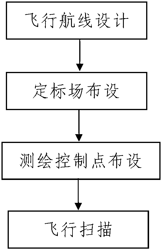
[0045] Such as figure 2 The shown method of ground control measurement based on airborne InSAR includes the following steps:

[0046] Step 1. Flight route design: First, determine the range of the area to be surveyed and mapped based on the pre-collected topographic data of the survey area; then, combine the range of the determined area to be surveyed and mapped and the flight parameters during the surveying and mapping process to survey and map the airborne InSAR system In the process, the number of sorties N and the flight route of each sortie are designed.

[0047] The flight parameters include the flight direction, the length of the survey strip, the survey bandwidth, the number of survey strips covered by each flight, the beam center angle of view of the radar antenna used by the airborne InSAR system, and the beam of the radar antenna used by the airborne InSAR system in the upward direction. Width and overlap rate of InSAR images acquired by the airborne InSAR system. Amon...

Embodiment 2

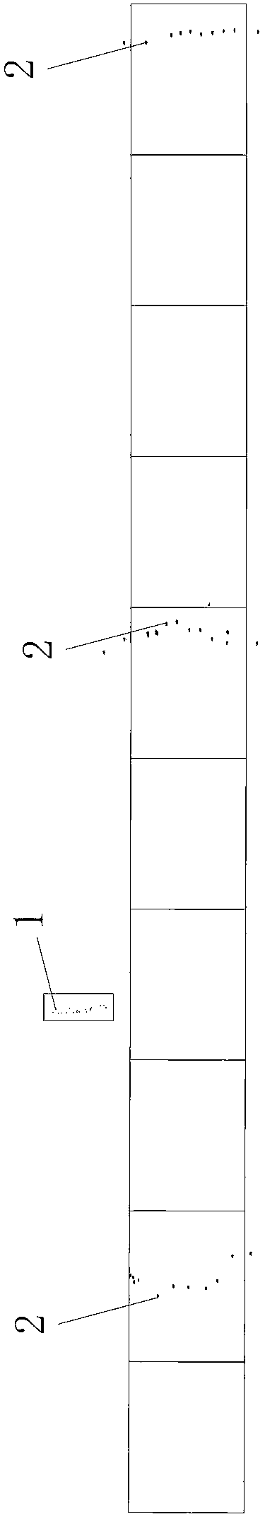
[0099] In this embodiment, the difference from embodiment 1 is that the scale of the drawing in step 1 is 1:50,000, and the measurement area is 8 plots of 1:50,000 in Mianyang, Sichuan, with an area of ​​approximately 3504.48 square kilometers. Details see Figure 4 ; The length of the surveying zone in step one is 175km±5km, the surveying and mapping bandwidth is 5072m±50m, the number of surveying zones covered by each flight is 5-7, and all the surveying and mapping areas of N flights cover the entire area to be surveyed And expand 2.5km to the circumference of the area to be surveyed; the beam center angle of view of the radar antenna used by the airborne InSAR system is 45°, and the overlap rate of the InSAR images acquired by the airborne InSAR system is 40%; as described in step 2 The number of calibration fields is two, and the two calibration fields are both arranged in the measurement area, and the distance between two adjacent calibration points 1 is 400m~1000m; each o...


PUM


Abstract

The invention discloses a ground control and measurement stationing method based on an onboard interferometric synthetic aperture radar (InSAR). The method comprises the following steps of: 1, designing a flight line, namely determining a range of a region to be plotted according to pre-collected information of a detection region terrain and designing the number N of sorties required to fly and the flight line of each sortie according to the determined range of the region to be plotted and flight parameters during plotting; 2, arranging calibration fields, namely arranging one or two calibration fields for radiating and geometrically calibrating an onboard InSAR system inside or outside the detection region; 3, stationing plotting control points; and 4, scanning flight, namely after the N sorties fly in the calibration fields and the detection region, acquiring InSAR measurement data in the region to be plotted. By the method, the steps are rational in design, the use operation is simple, and the using effect is good; and the shortcoming that the onboard InSAR terrain plotting control and measurement cannot be instructed according to the technical rule of the conventional optical system is overcome.

Description

Technical field [0001] The invention belongs to the technical field of airborne synthetic aperture radar interferometry, and particularly relates to an airborne InSAR-based ground control measurement method suitable for flat land and hilly areas. Background technique [0002] InSAR (Interferometric Synthetic Aperture Radar; abbreviation: Interferometric Synthetic Aperture Radar or Synthetic Aperture Radar Interferometry) technology originated from the United States and has been continuously improved and matured in developed countries in Europe and America, and its application fields have also been continuously promoted. For countries with advanced InSAR technology, such as the space information industry technology companies in the United States and Germany, the practical airborne high-resolution InSAR technology has been used as a new and advanced technical means for topographic surveying, forest surveying, and With the rapid development of resource survey and environmental mappi...

Claims


Application Information

Patent Timeline
Patent Type & Authority Applications(China)
IPC IPC(8): G01S13/90
Inventor 谭克龙向茂生王宇苗小利彭桂辉原喜屯梁涛宋健
Owner XIAN MEIHANG INFORMATION IND
Why Eureka
Try Eureka