Autonomous navigation method based on earth satellite and lunar satellite combined ranging

An earth satellite and autonomous navigation technology, applied in the field of satellite autonomous navigation, can solve the problems of weak observability of the navigation system and difficulty in realizing high-precision navigation, and achieve high-precision results

Active Publication Date: 2013-03-27
BEIJING INST OF CONTROL ENG
View PDF5 Cites 18 Cited by
  • Summary
  • Abstract
  • Description
  • Claims
  • Application Information

AI Technical Summary

Problems solved by technology

However, in the case where the two satellites participating in the navigation are both earth satellites, since the moon's gravity has little influence on the dynamics of the earth satellite, the observability of the navigation system is weak, and it is still difficult to achieve high-precision navigation in fact.

Method used


Image

  • Autonomous navigation method based on earth satellite and lunar satellite combined ranging
  • Autonomous navigation method based on earth satellite and lunar satellite combined ranging
  • Autonomous navigation method based on earth satellite and lunar satellite combined ranging

Examples


Embodiment Construction

[0030] Specific embodiments of the present invention will be further described in detail below in conjunction with the accompanying drawings.

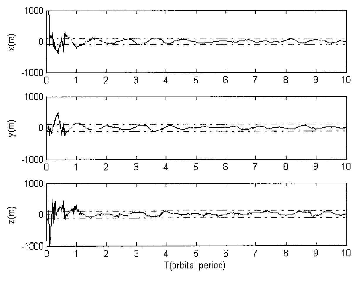
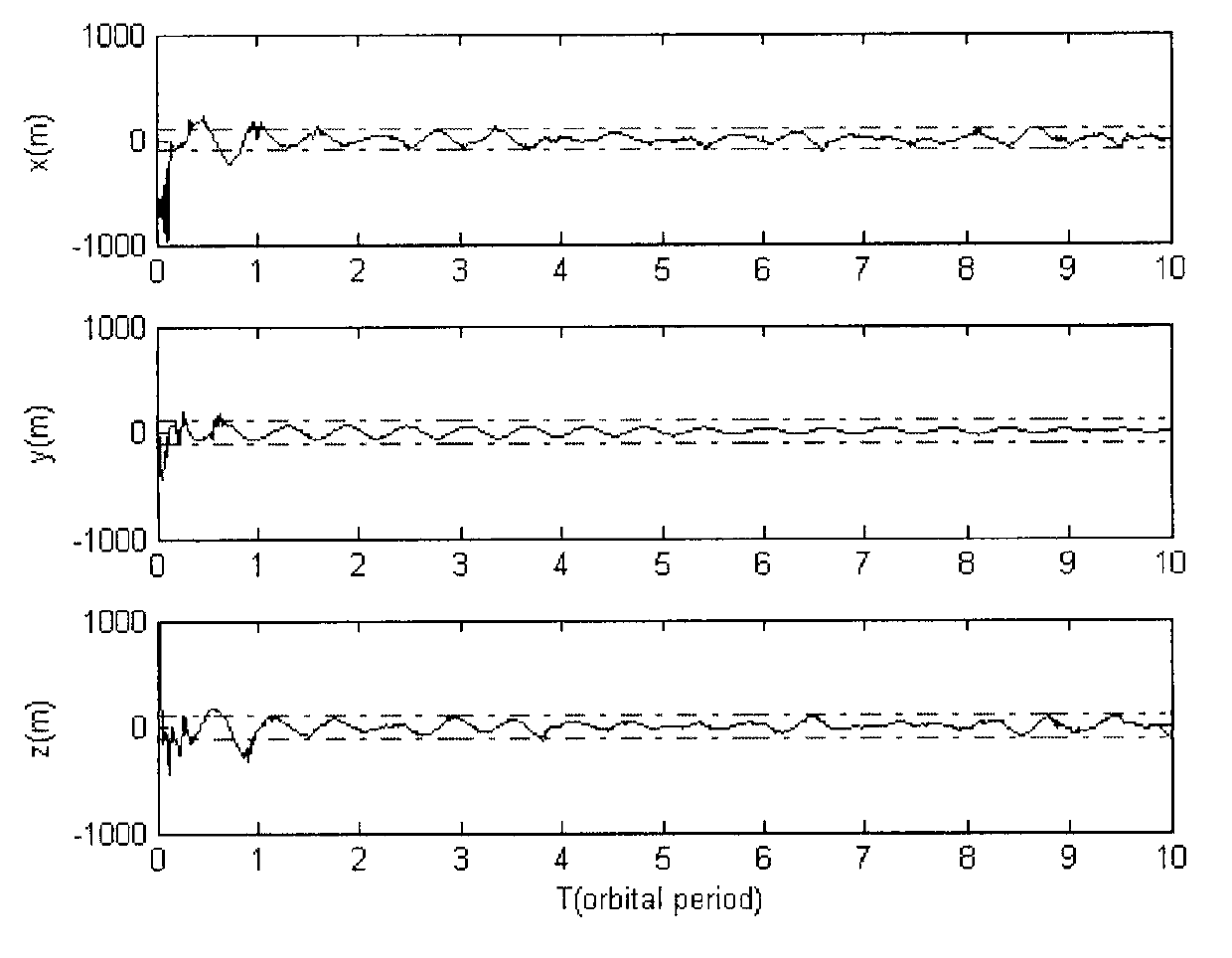
[0031] Aiming at the problem that the existing technology is difficult to realize high-precision autonomous navigation, the present invention proposes that an inter-satellite link can be established between the earth satellite and the moon satellite to measure the inter-satellite distance. At this time, the dynamic characteristics of the two satellites are respectively affected by the earth and the significant influence of the moon's gravity. In this case, the navigation system not only has observability, but also has a high degree of observability. Based on the distance measurement information between the earth satellite and the moon satellite, as well as the three-body orbital dynamics equation, by using the Extended Kalman Filter (EKF) algorithm, the absolute position of the earth satellite and the moon satellite can be estimated at...


PUM


Abstract

Provided is an autonomous navigation method based on earth satellite and lunar satellite combined ranging. A basic method is that an inter-satellite link is built between an earth satellite and a lunar satellite and used for conducting inter-satellite distance measuring; and on the basis of the distance information between the earth satellite and the lunar satellite and a three-body track kinetic equation and by means of an extend kalman filter algorithm, and simultaneously by estimating an absolute position of the earth satellite and the lunar satellite, high-precision autonomous navigation only depending on the inter-satellite distance measuring information is achieved. The method can be used for achieving satellite autonomous navigation tasks with high precision requirements, is favorable for reducing depending degree of satellites on ground observation and control, and improves independent survival ability of a satellite system under an emergency condition.

Description

technical field [0001] The invention relates to an autonomous navigation method based on joint ranging of earth satellites and lunar satellites, and belongs to the technical field of satellite autonomous navigation. Background technique [0002] Satellite autonomous navigation refers to the determination of its own position and speed only by the measurement, communication and computing equipment carried on the satellite without relying on the support of the ground measurement and control system. The realization of satellite autonomous navigation is the basis for satellite autonomous control, which helps to reduce the dependence of satellites on ground measurement and control, and enhance the autonomous survivability of satellite systems in emergency situations. However, at the current level of technology, medium and high orbit satellites lack high-precision autonomous absolute navigation means. Traditional satellite autonomous navigation methods include astronomical navigat...

Claims


Application Information

Patent Timeline
Patent Type & Authority Applications(China)
IPC IPC(8): G01S19/47
Inventor 熊凯魏春岭何英姿
Owner BEIJING INST OF CONTROL ENG
Why Eureka
Try Eureka