Remote sensing evaluation method of lake water reserves based on multispectral images

A multi-spectral image and lake water technology, applied in the field of satellite remote sensing and earth observation, can solve the problems of measurement cycle and cost limitations, and the inability to carry out large-scale promotion and application

Inactive Publication Date: 2013-10-23
INST OF REMOTE SENSING & DIGITAL EARTH CHINESE ACADEMY OF SCI
View PDF5 Cites 39 Cited by
  • Summary
  • Abstract
  • Description
  • Claims
  • Application Information

AI Technical Summary

Problems solved by technology

Although these methods can partially solve the problem of acquisition and update of underwater terrain data, they cannot be widely applied due to the limitation of measurement cycle and cost.

Method used


Image

  • Remote sensing evaluation method of lake water reserves based on multispectral images
  • Remote sensing evaluation method of lake water reserves based on multispectral images
  • Remote sensing evaluation method of lake water reserves based on multispectral images

Examples


Embodiment Construction

[0047] The embodiments of the present invention will be described in further detail below with reference to the accompanying drawings and examples. The following examples are intended to illustrate the present invention, but not to limit the scope of the present invention.

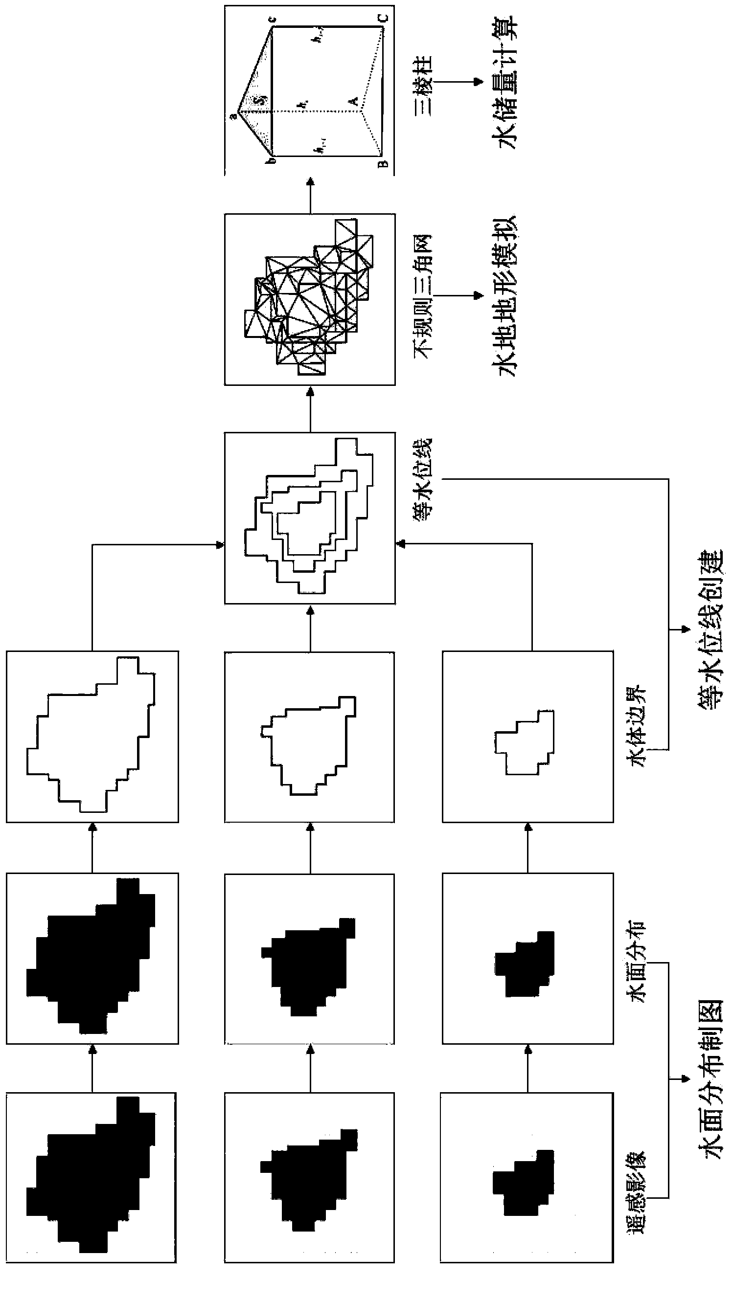
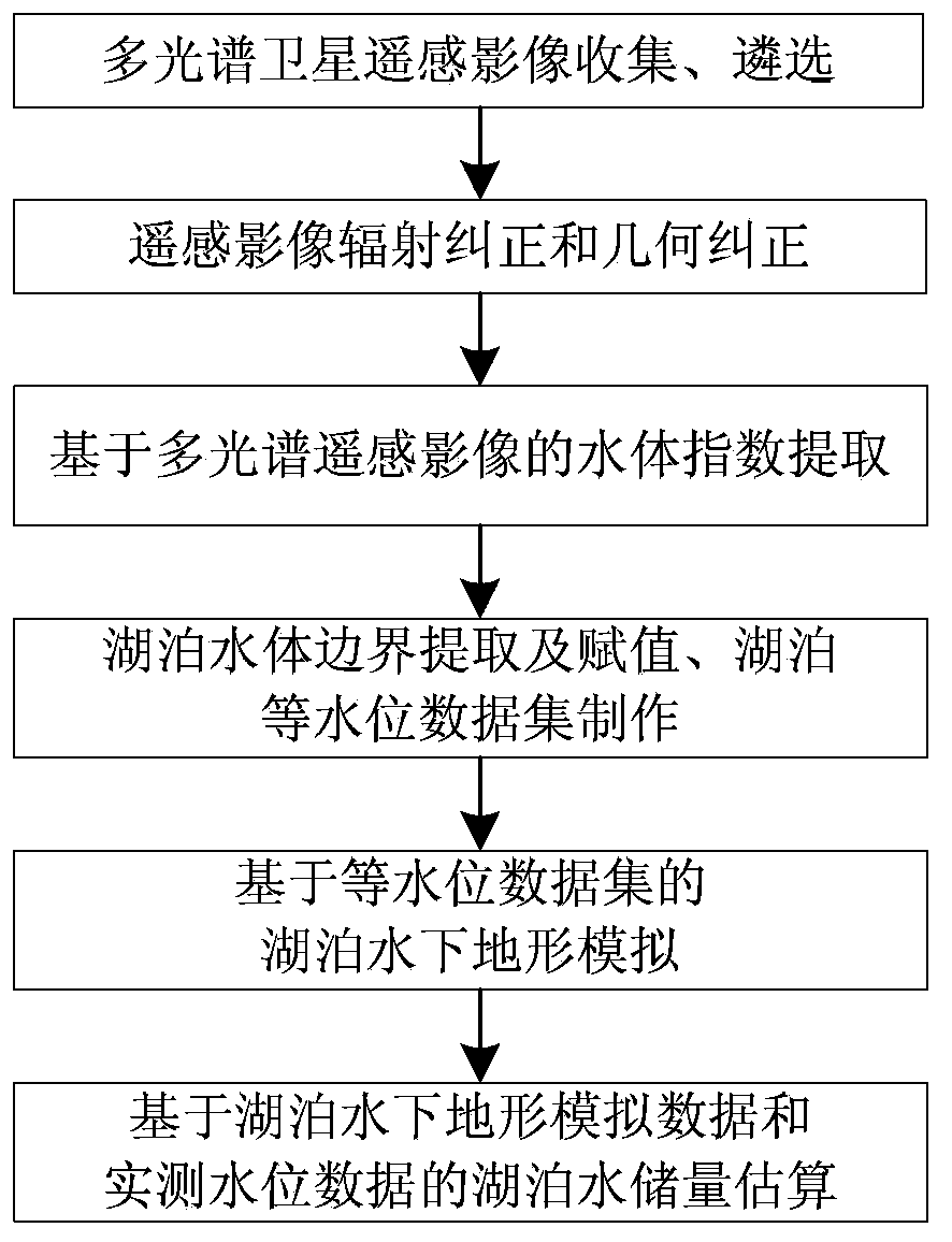
[0048] In order to better grasp the lake water storage and its changes in a large range, an embodiment of the present invention proposes a remote sensing estimation method for lake water storage based on multi-spectral images. figure 1 , the method includes:

[0049] S1. According to the spectral response characteristics of the lake water in different bands of the multispectral remote sensing image, extract the water index reflecting the distribution characteristics of the lake water surface;

[0050] S2. Obtain the lake water body boundary according to the extracted water body index, assign the measured lake water level information to the lake water body boundary, and generate the lake water level data s...


PUM


Abstract

The invention provides a remote sensing evaluation method of lake water reserves based on multispectral images. The remote sensing evaluation method includes: according to lake water body spectral response characteristics in different bands of multispectral remote sensing images, extracting water body indexes which reflect lake water surface distribution characteristics; according to the extracted water body indexes, obtaining lake water body boundaries, giving actually-measured lake water level information to the lake water body boundaries, and generating lake equal water level line data sets according to different periods of the lake water body boundaries; according to the lake equal water level line data sets, simulating lake underwater topography; and calculating the lake water reserves in different periods according to the simulated lake underwater topography and actually-measured water level data. According to the remote sensing evaluation method, the lake underwater topography is monitored through utilization of multispectral satellite remote sensing data, the utilized satellite remote sensing data substantially can be obtained for free, and the remote sensing data has the advantages of wide space coverage areas and rapid refreshing speed, so that compared with conventional field actual-measurement methods, the remote sensing evaluation method provided by the embodiment of the invention has the advantages of low monitoring cost, convenient refreshing, and possibility of wide-range popularization and application.

Description

technical field [0001] The invention relates to the field of satellite remote sensing and earth observation, in particular to a method for estimating remote sensing of lake water storage based on multispectral images. Background technique [0002] Lakes (including natural lakes and artificial ponds) are the most important forms of surface water resources. After glaciers and permanent snow cover, lake water is the second largest type of surface water resource, and it is one of the main factors affecting global sea level change. Lake evolution is closely related to environmental changes: on the one hand, changes in water volume and sedimentary environment caused by lake surface fluctuations can sensitively indicate climate change; influences. However, for a long time, due to the limitation of survey and observation data, simulation and analysis methods, people cannot accurately obtain the water resources reserves of large-scale lakes and describe their dynamic changes, which...

Claims


Application Information

Patent Timeline
Patent Type & Authority Applications(China)
IPC IPC(8): G01C13/00G06T7/00
CPCY02A90/30
Inventor 卢善龙欧阳宁雷吴炳方肖高怀
Owner INST OF REMOTE SENSING & DIGITAL EARTH CHINESE ACADEMY OF SCI
Why Eureka
Try Eureka