
Automatic Batch Extraction Method of Horizontal Vector Outlines of Buildings in Satellite Images

A technology of satellite imagery and extraction method, which is applied in image analysis, image data processing, instruments, etc., and can solve the problems of tediousness, difficulty in automatic contour line generation, and low efficiency

Active Publication Date: 2016-10-05
NORTHWESTERN POLYTECHNICAL UNIV
View PDF5 Cites 0 Cited by
  • Summary
  • Abstract
  • Description
  • Claims
  • Application Information

AI Technical Summary

Problems solved by technology

The research objects of the above methods are all grayscale images, not suitable for color images, so the rich color information in color images cannot be used
In addition, the snake model method is sensitive to the initial position, and needs to rely on other mechanisms to place the initial contour near the image features of interest, otherwise the contour extraction will fail. At present, most of them use manual selection to set the initial boundary, which is not only very cumbersome , and it makes it difficult to automatically generate contour lines
However, there are two deficiencies in the more commonly used region growing method: first, the selection of the initial seed point
Most of the current methods for selecting seed points are manually selected, requiring a lot of manual intervention, time-consuming, laborious, and inefficient
The second is the selection of the growth threshold
The result of this method is greatly affected by the selection of the distance threshold. In order to obtain better results, each building in the image needs to correspond to a different distance threshold. In the past, the method of setting the distance threshold was often manually set based on experience. low efficiency

Method used


Image

  • Automatic Batch Extraction Method of Horizontal Vector Outlines of Buildings in Satellite Images
  • Automatic Batch Extraction Method of Horizontal Vector Outlines of Buildings in Satellite Images
  • Automatic Batch Extraction Method of Horizontal Vector Outlines of Buildings in Satellite Images

Examples


Embodiment 1

[0137] Example 1: The original image is a 702*902 pixel satellite image of a certain area in Beijing to extract the outline of the building.

[0138] Use a Gaussian smoothing filter with a variance σ=0.8 and a window size of 7*7 to smooth the original image; in the Hsv space, keep the h value of each pixel unchanged, v=v+0.08, s=s+0.07 Image enhancement processing is performed to enhance the color contrast between the building and the background. Store the processed image as I orig , as the source image for subsequent processing.

[0139] Image I orig In the a, b color subspace of Lab color space, the number of peaks is 3, as the category number when it is divided into building areas with K-means algorithm, the image after segmentation is saved as I seg , in this example, the building area exists in category 3. Then for image I seg Perform grayscale and binarization processing to obtain its binarized image I bw , at this time I bw The number of connected areas in is 100...

Embodiment 2

[0151] Example 2: The original image is a satellite image of the Purdue University dormitory area of ​​775*401 pixels to extract the outline of the building.

[0152] Use a Gaussian smoothing filter with a variance σ=0.8 and a window size of 7*7 to smooth the original image; in the Hsv space, keep the h of each pixel unchanged, v=v+0.06, s=s+0.05 Image enhancement processing enhances the color contrast between the building and the background. Store the processed image as I orig , as the source image for subsequent processing.

[0153] Image I orig In the a, b color subspace of Lab color space, the number of peaks is 3, as the category number when it is divided into building areas with K-means algorithm, the image after segmentation is saved as I seg , in this example, the building area exists in category 2. Then for image I seg Perform grayscale and binarization processing to obtain its binarized image I bw , at this time I bw The number of connected areas in is 16, inc...

Embodiment 3

[0166] Embodiment 3: The original image is a satellite image of a certain area in Xi'an with 874*383 pixels, and the outline of the building is extracted.

[0167] Use a Gaussian smoothing filter with a variance σ=0.8 and a window size of 7*7 to smooth the original image; in the Hsv space, keep the h of each pixel unchanged, v=v+0.07, s=s+0.06 Image enhancement processing enhances the color contrast between the building and the background. Store the processed image as I orig , as the source image for subsequent processing.

[0168] Image I orig In the a and b color subspaces of Lab color space, the number of peaks is 5, as the category number when it is divided into building areas with K-means algorithm, the image after segmentation is saved as I seg , in this example, the building area exists in category 1. Then for image I seg Perform grayscale and binarization processing to obtain its binarized image I bw , at this time I bw The number of connected areas in is 84, in...


PUM


Abstract

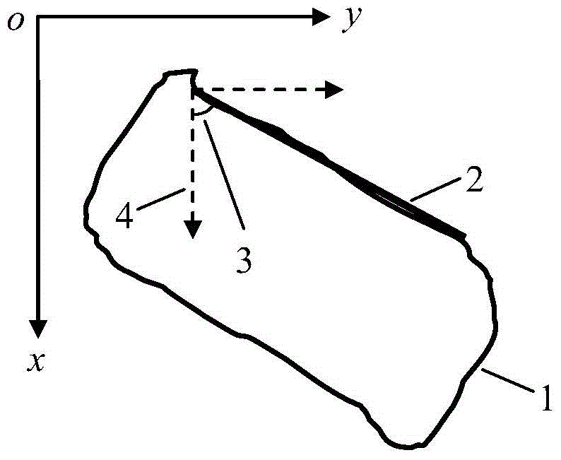
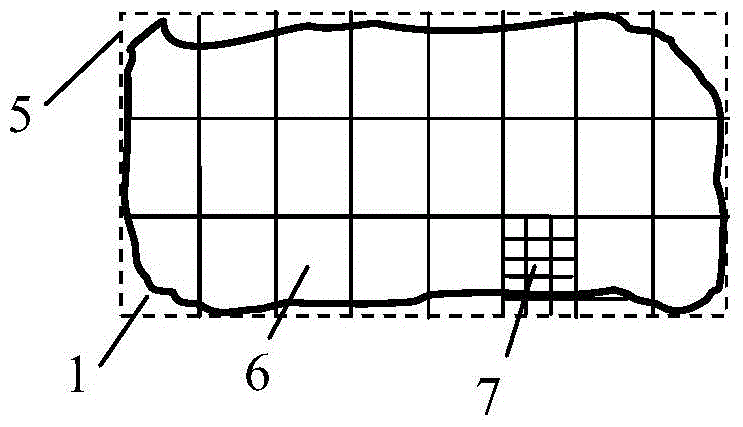
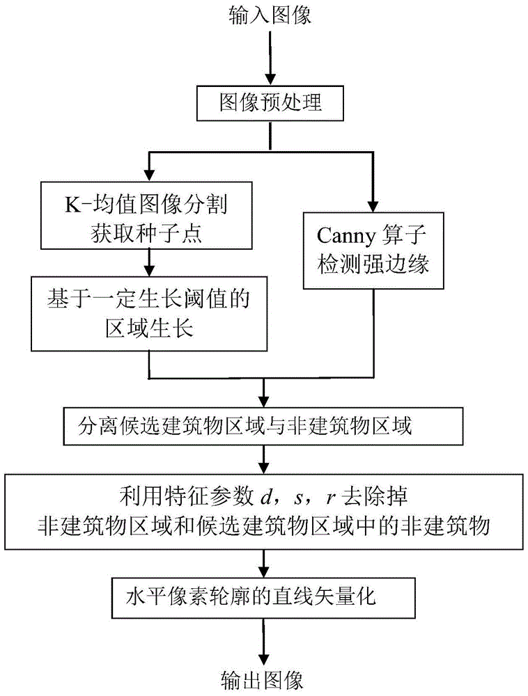
The invention provides an automatic batch extraction method for horizontal vector contours of buildings in satellite images. The method comprises the steps of firstly using a K-means algorithm to class the images to obtain the backbone parts of the buildings, and solving the problem of selection of initial seed points by taking mass centers of all building areas; after the areas of all the seed points are grown, separating the building areas from surrounding areas by virtue of image edge information and removing non-building areas according to characteristic parameters such as rectangularity and strip index to realize the automatic extraction of the horizontal pixel contours of the buildings; then using techniques such has Hough transformation and block processing to perform linear vector processing to the horizontal pixel contours, and finally obtaining the horizontal vector contours of all buildings in a batch. The automatic batch extraction method for the horizontal vector contours of the buildings in the satellite images is applicable to the batch and quick extraction of the horizontal vector contours of common polygonal buildings with top views which are of straight-line segment structures in the satellite images.

Description

technical field [0001] The invention relates to a method for automatically batch-extracting the horizontal vector outlines of buildings from a single satellite image of building groups, in particular to the automatic batch-extraction of the horizontal vector outlines of buildings whose top view is a straight-line structural polygon. Background technique [0002] Using a single satellite image to achieve virtual reconstruction of 3D scenes is a very active research topic. It is mainly used in urban construction planning, military scene simulation, resource management, earthquake relief simulation, etc. In the 3D virtual reconstruction of real scenes, most of them are ordinary buildings with simple structures and straight-line structural polygons in the top view. How to realize the rapid modeling of such a large number of ordinary buildings is the key to efficient reconstruction of 3D buildings. How to automatically extract the horizontal outlines of buildings from the images ...

Claims


Application Information

Patent Timeline
Patent Type & Authority Patents(China)
IPC IPC(8): G06K9/54G06T7/60
Inventor 齐敏家建奎李珂樊养余齐榕赵子岩
Owner NORTHWESTERN POLYTECHNICAL UNIV
Learn More