Relational and Key-Value type database spatial data index method
What is AI technical title?
AI technical title is built by Patsnap AI team. It summarizes the technical point description of the patent document.
A database and relational technology, applied in the direction of electrical digital data processing, special data processing applications, instruments, etc., can solve problems such as high cost
Active Publication Date: 2014-04-09
CHINA UNIV OF GEOSCIENCES (WUHAN)
View PDF5 Cites 18 Cited by
Summary
Abstract
Description
Claims
Application Information
AI Technical Summary
This helps you quickly interpret patents by identifying the three key elements:
Problems solved by technology
Method used
Benefits of technology
Problems solved by technology
For the case of massive spatial data, the cost of rebuilding the index encoding is quite large
Method used
Image
Click on the blue label to locate the original text in one second.
Reading with bidirectional positioning of images and text.
Examples
Embodiment 1
[0039] Embodiment 1: the present invention provides a kind of unified relational type and Key-Value type database spatial data indexing method, and operation steps are as follows:
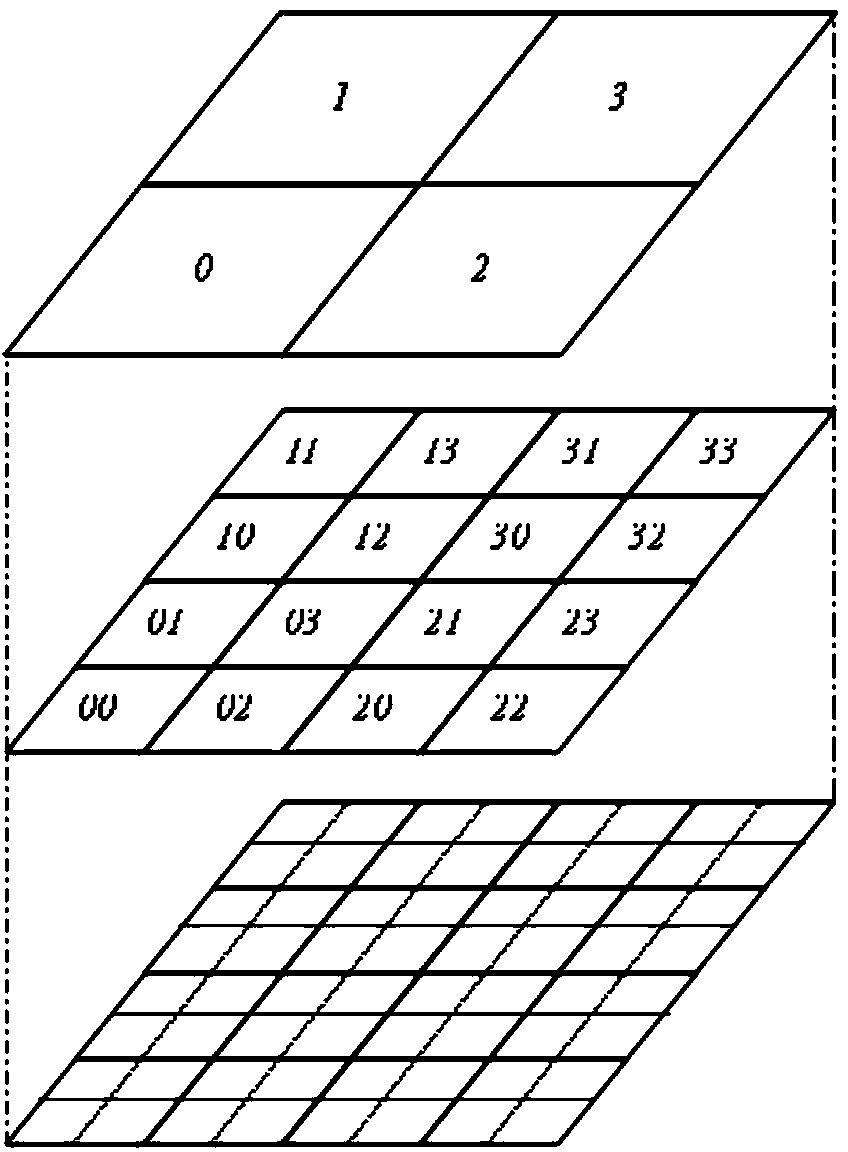
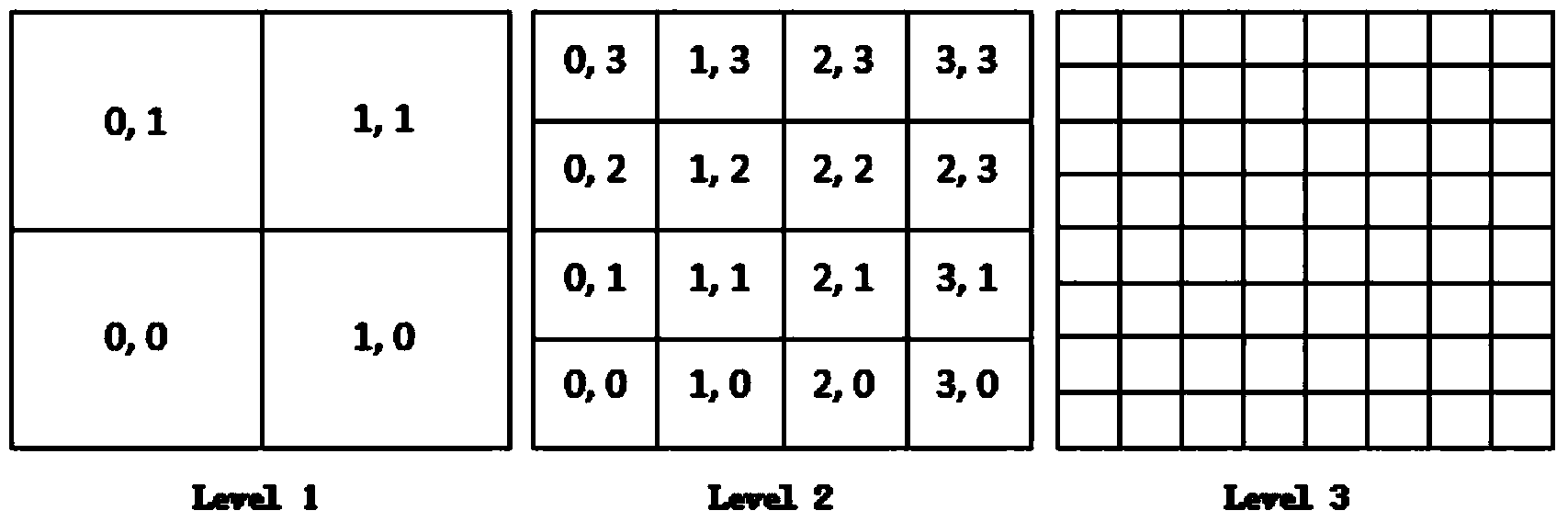
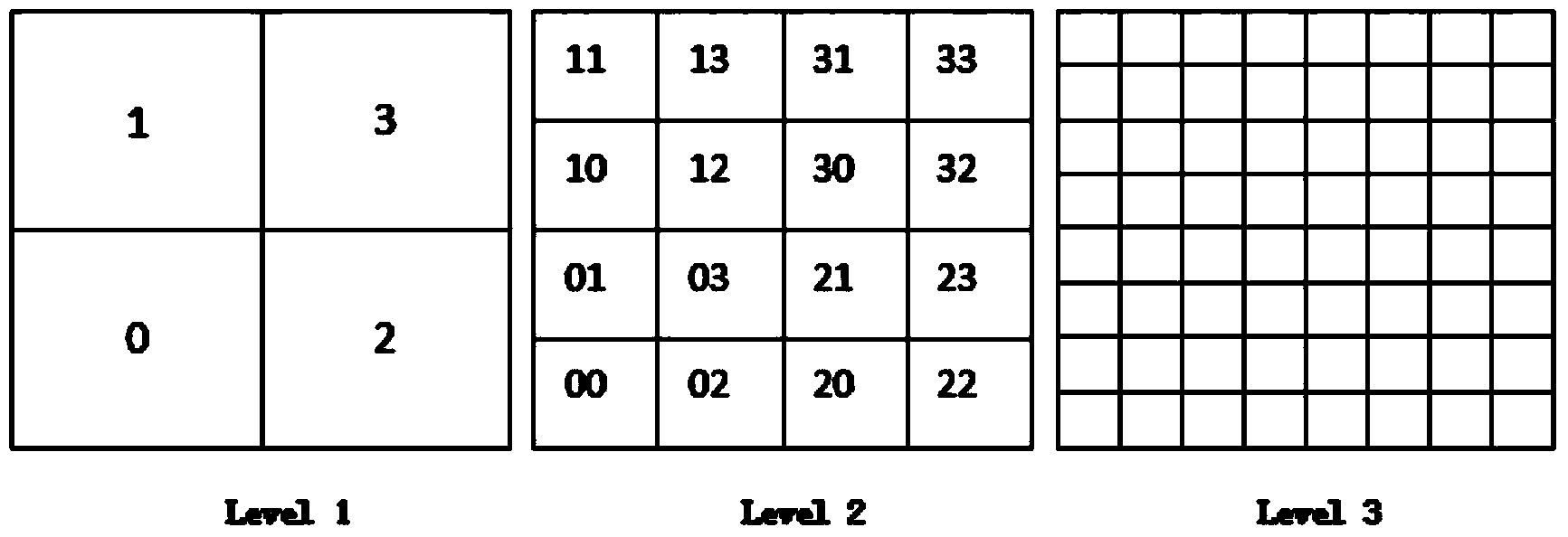
[0040] Step 1: Organize the space vector data into layers, divide the index layer and index grid according to the coordinate range of the layer data, and the grid of the next index layer is quartered on each grid of the previous index layer As a result, each grid has a unique one-dimensional code and two-dimensional row-column code, specifically:
[0041] 1) Space vector data is organized into layers according to classification, and the index layer is divided according to the coordinate range of the layer or the coordinate range of the reference system where the layer is located. The index layer is 24 layers, and the top index layer is No. 0 index layer, only one Grid, indicating the entire coordinate range MBR (Xmin, Ymin, Xmax, Ymax), there are 4 grids in the index layer 1, which are obtained by ...
Embodiment 2
[0068] Embodiment 2: the method for querying the unified relational and Key-Value type database space data that adopts the method of the present invention to set up, the step of concrete query is:
[0069] (1) According to the relational database-based data storage and spatial index establishment method of the present invention, the steps of performing a spatial rectangular range MBR (Xmin, Ymin, Xmax, Ymax) query on a layer are:
[0070] a) Obtain the effective index layer number range of the layer from the layer metadata table: (MinLevel, MaxLevel).
[0071] b) Traverse each index layer i within the range of (MinLevel, MaxLevel), calculate the grid coordinate range GBR (X1, Y1, X2, Y2) of MBR on Level i, and then store the index layer number i in the first byte In the middle (left shift 24 bits), the grid coordinates (X1, Y1, X2, Y2) are stored in the remaining 3 bytes respectively, and the two-dimensional index code representation of GBR is obtained: (MinXI, MinYI, MaxXI, M...
PUM
Abstract
The invention relates to a relational and Key-Value typedatabase spatial vector data index method. Spatial data form layers according to classifications, index layers and index grids are divided according to coordinate ranges of layer data, and each grid is given a unique two-dimensional array code and a one-dimensional code; each element of each layer is traversed, the coverage relation between each element and the corresponding index grid is calculated according to the graph of the element, and accordingly the index layer which the element belongs to and the grid covered with the element are obtained; the array code of the grid which the element belongs to serves as a spatial index code of the element and is stored in a layer index table of a relational database, and the one-dimensional codes of the grids serve as line keys of the layer index table in a Key-Value typedatabase after composite design. The method unifies the index mode of spatial vector data in the relational database and the index mode of spatial vector data in the Key-Value typedatabase, and a spatial index does not need to be built again when the spatial data migrate between the relational database and the Key-Value type database.
Description
technical field [0001] The invention relates to the fields of spatial data management and spatial information processing, in particular to a method for establishing a consistent spatial index for spatial vector data stored in relational databases and Key-Value databases. Background technique [0002] Spatial data focuses on the geometric shape of spatial features, and expresses the real world in the form of points, lines, and polygons. With the improvement of spatial data collection capabilities and the development of geographic information systems, spatial data has grown rapidly, and there are more and more network applications based on GIS-based large-scale data and high traffic loads. When a relational database is used to store these massive spatial data, it is difficult to provide users with high-concurrency and low-latency services with the data storage capacity of a single node. In order to improve access efficiency, clusters can be used to solve such problems, but th...
Claims
Application Information
Patent Timeline
Application Date:The date an application was filed.
Publication Date:The date a patent or application was officially published.
First Publication Date:The earliest publication date of a patent with the same application number.
Issue Date:Publication date of the patent grant document.
PCT Entry Date:The Entry date of PCT National Phase.
Estimated Expiry Date:The statutory expiry date of a patent right according to the Patent Law, and it is the longest term of protection that the patent right can achieve without the termination of the patent right due to other reasons(Term extension factor has been taken into account ).
Invalid Date:Actual expiry date is based on effective date or publication date of legal transaction data of invalid patent.

