A low-altitude flight simulation method for aerial geophysical prospecting of unmanned aerial vehicles

A low-altitude flight and aeronautical geophysical prospecting technology, applied in the field of low-altitude flight simulation, can solve problems such as UAV collisions and UAV flight accidents, reduce the change range, assist UAV aeronautical geophysical exploration work, and improve work efficiency Effect

Active Publication Date: 2017-01-25
CHINA ACAD OF AEROSPACE AERODYNAMICS
View PDF5 Cites 0 Cited by
  • Summary
  • Abstract
  • Description
  • Claims
  • Application Information

AI Technical Summary

Problems solved by technology

[0003] However, the biggest difficulty in applying UAVs to the field of aeronautical geophysical prospecting is that the UAV flight platform needs to be able to fly along the terrain at ultra-low altitude, and the UAV needs to be able to better track the terrain and fly stably.
During the low-altitude undulating flight of the UAV along the terrain, due to the flight characteristics of the aircraft itself, the characteristics of the climbing ability, and the unpredictability of unknown obstacles, for mountainous terrain with large slopes, hilly terrain with large fluctuations, or relatively large High ground obstacles and hills, there is a risk that the drone will collide with them, causing drone flight accidents

Method used


Image

  • A low-altitude flight simulation method for aerial geophysical prospecting of unmanned aerial vehicles
  • A low-altitude flight simulation method for aerial geophysical prospecting of unmanned aerial vehicles

Examples


Embodiment

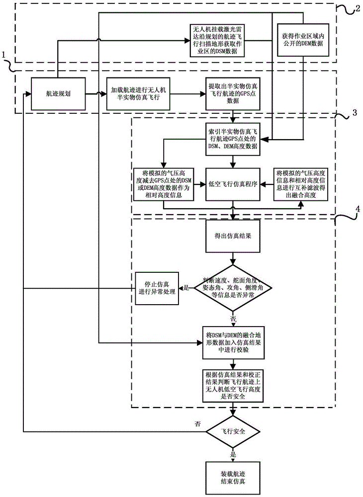
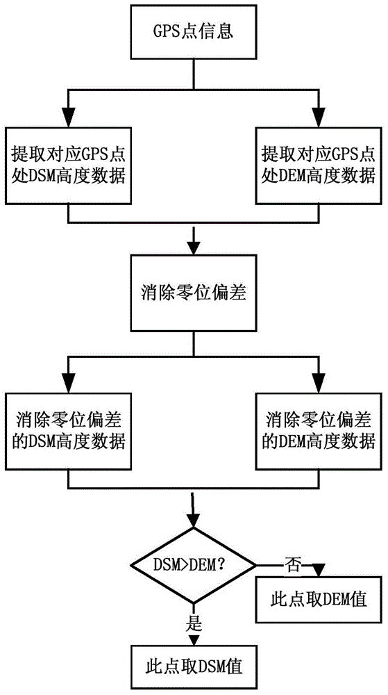
[0035] Embodiment: the process can include aerial geophysical prospecting operation area track planning; Mount laser radar flight scanning DSM terrain data in the unmanned aerial vehicle operation area; Matlab low-altitude control flight mathematical simulation based on the operation area track height data; for Matlab low-altitude flight Control simulation results correction and analysis of four parts.

[0036] In the first part, the flight path of the operation area is planned first, and the flight path of the aeronautical geophysical prospecting operation area is determined. The track of the aerial geophysical prospecting operation area is loaded into the hardware-in-the-loop simulation system, and the full GPS latitude and longitude information of the UAV flying along the track of the aerial geophysical prospecting operation area is obtained, and all the flight GPS data obtained are saved in an Excel table.

[0037] In the second part, according to the operation area of ​​t...


PUM


Abstract

The invention discloses a low-altitude flight simulation method for airborne geophysical prospecting of an unmanned aerial vehicle. A laser radar mounting flight is introduced to before-flight simulation, accuracy DSM (digital surface model) data of a work zone are acquired, and more-complete altitude data are provided for low-altitude flight simulation. The low-altitude flight simulation method is capable of accurately simulating various postures of low-altitude flight of the unmanned aerial vehicle on planned flight paths and evaluating whether ground barriers (signal towers, telegraph poles, tall trees, buildings, high-rise buildings and bridges and the like) in the flight paths of the unmanned aerial vehicle damage flight safety of the unmanned aerial vehicle or not, flight altitude over the ground during low-altitude flight of the unmanned aerial vehicle is visually analyzed from simulation results, safety of the ultralow-altitude flight of the unmanned aerial vehicle in the flight paths is judged, modification of the prior art is reduced, operation efficiency is improved, flight safety of the unmanned aerial vehicle is guaranteed, mountain collision during flight of the unmanned aerial vehicle is avoided, and airborne geophysical prospecting of the unmanned aerial vehicle is effectively assisted.

Description

technical field [0001] The invention relates to a low-altitude flight simulation method, in particular to a low-altitude flight simulation method applied to aerial geophysical exploration of unmanned aerial vehicles, and belongs to the field of aerial geophysical exploration of unmanned aerial vehicles. Background technique [0002] At present, airborne geophysical prospecting (airborne geophysical prospecting, is a kind of geophysical prospecting method. It is a method of studying and searching for underground geological structures and minerals by detecting changes in various geophysical fields during navigation through special geophysical prospecting instruments equipped on aircraft. A geophysical prospecting method.) With manned aircraft as the main carrier, problems are becoming increasingly prominent while achieving gratifying results, and unmanned aerial vehicle has become an effective way to solve related problems to a large extent. First, there is a high risk of mann...

Claims


Application Information

Patent Timeline
Patent Type & Authority Patents(China)
IPC IPC(8): G05B17/02
Inventor 蔡永恒尤向荣樊自伟
Owner CHINA ACAD OF AEROSPACE AERODYNAMICS
Why Eureka
Try Eureka